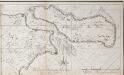
Maps of Zealand
Zeelandia insvla : Danicarum maxima
1 : 390000 Annotatie: Met opdracht van Joan Blaeu aan Petrus Charisius; Origineel is Blad 145 in atlas factice; Annotatie geografische gegevens: Met schaalstok [Amsterdam] : [Joan Blaeu]
Selandiae In Regno Daniae Insulae Chorographica Descriptio. [Karte], in: Novus atlas absolutissimus, Bd. 1, S. 125.
1 Karte aus Atlas Janssonius Offizin
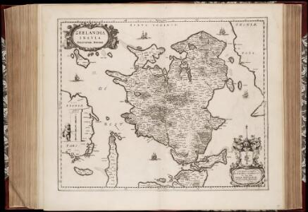
ZEELANDIA | INSVLA | Danicarum Maxima.
[Amsterdam : Joan Blaeu]


Insvlae Danicae in Mari Balthico sitae utpote Zeelandia, Fionia, Langelandia, Lalandia, Falstria, Fembria Mona repraesentatae
1 : 470000 Baltské moře-oblast Homann, Johann Baptist J.B. Homann
Insvlae Danicae in mari Balthico sitae utpote Zeelandia, Fionia, Langelandia, Lalandia, Falstria, Fembria Mona
1 : 470000 Baltské moře-oblast Homann, Johann Baptist a Ioh. Bapt. Homanno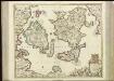
[67][67] Insularum Danicarum ...., uit: Atlas sive Descriptio terrarum orbis
Annotatie: Gedigitaliseerde versie. Amsterdam. Heiloo : Picturae (vervaardiger), 2015. tiff-bestand. Gedigitaliseerd: 07-01-2015; Origineel: Universiteitsbibliotheek Vrije Universiteit (XL.05127.-) ; Netherlands; Titelpagina ontbreekt Wit, Frederik de Amsterdam : Frederick de Wit
Korsör 12, uit: Special-Karte von Mittel-Europa / nach amtlichen Quellen bearbeitet von W. Liebenow
1 : 300000 titelvariant: W. Liebenow's Mittel-Europa; Annotatie: Titel boven de bladen: W. Liebenow's Mittel-Europa Johannes Wilhelm Liebenow 1822-1897 Frankfurt a. M. : Ludwig Ravenstein
Roskilde 3, uit: Special-Karte von Mittel-Europa / nach amtlichen Quellen bearbeitet von W. Liebenow
1 : 300000 titelvariant: W. Liebenow's Mittel-Europa; Annotatie: Titel boven de bladen: W. Liebenow's Mittel-Europa Johannes Wilhelm Liebenow 1822-1897 Frankfurt a. M. : Ludwig Ravenstein
FIONIA | vulgo | FVNEN.
[Amsterdam : Joan Blaeu]

Fionia [Karte], in: Gerardi Mercatoris Atlas, sive, Cosmographicae meditationes de fabrica mundi et fabricati figura, S. 149.
1 Karte aus Atlas Mercator, Gerhard Montanus, Petrus
Fionia [Karte], in: Gerardi Mercatoris et I. Hondii Newer Atlas, oder, Grosses Weltbuch, Bd. 1, S. 112.
1 Karte aus Atlas Mercator, Gerhard und Hondius, Jodocus Jansson, Jan

Strait Denmark-Sweden.
1 : 150000 Nordenankar, J.
Den nordöstlige Deel af Sjælland
1 : 160000 samlet, tegnet og lithogr. af J.H. Mansa [København] : trykt i det Kongl. Steentr.
Ostsee
1 : 100000 Baltské moře Reichs-Marine-Amt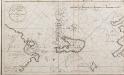
Netto afteekening van de Bay van Ebeltuds Wyk en het eyland Sampsoen in't groot
Denmark Johannes van Keulen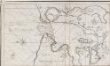
Isen Fioerd in't groot in't eyland Zeeland in de Belt
Denmark Johannes van Keulen
Lalandiae et Falstriae Accurata Descriptio. [Karte], in: Novus atlas absolutissimus, Bd. 1, S. 128.
1 Karte aus Atlas Janssonius Offizin
LALANDIA, | FALSTRIA | et | MONA | INSVLÆ | IN MARI BALTHICO.
Joannes Blaeu Excudit.
Fionia
1 Karte : Kupferdruck ; 34 x 38 cm Mercator; Hondius Henricus Hondius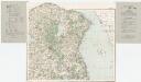
[Kaart], uit: Danmark 1:100.000 : Generalstabskort
1 : 100000 titelvariant: Generalstabskort; Annotatie: Incompleet; Voor aanwezige bladen zie overzichtsblad Købnhavn : Geodaetisk Institut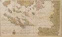
Dese eijlanden leggen aen de zuijtkand vant eijland Fuijnen in de Belt of Oostzee
Denmark Gerard van Keulen
AROE | INSVLÆ | DELINEATIO | GEOMETRICA.
AVCT. ANDREA BVRÆO | SVECO. [Amsterdam : Joan Blaeu]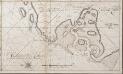
Het Gat van Naskou of Maschou int groot aen de Westkust van Laland in de Belt
Denmark Johannes van Keulen
Kjöbenhavn : med nærmeste omegn 1903
1 : 10000 Kjøbenhavns Kommunes Foranstaltning Kjøbenhavns Kommunes Ejendomme