Maps of Balkan Pen.
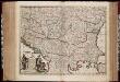
Nova totius Hungariae, Transilvaniae, Serviae, Romaniae, Bulgariae, Walachiae, Moldaviae, Sclavoniae, Croatiae, Bosniae, Dalmatiae, maximaeq[ue] partis Danubii fluminis, descriptio / emendata a F. de Wit
1 : 2600000 Annotatie: Tekst impressum in het Nederlands; Rechtsboven: 21; Kaart toont Hongarije, omliggende landen en een belangrijk deel van de loop van de Donau; Origineel is Blad 129 in atlas factice; Annotatie geografische gegevens: Schaalstok linksonder cartouche: Milliaria Germanica communia 15 uni gradui = Gemeene Duytsche Mylen van 15 in een graedt Frederick de Wit 1630-1706 Amsterdam : gedruckt by Frederick de Wit inde Kalverstraet by den Dam inde Witte Pascaert
[Ost-Europa in 6 Blättern, Blatt 5]
Handatlas über alle Theile der Erde und über das Weltgebäude Stieler, Adolf Justus Perthes
Ost-Europa, No. 5: Sud-West-Russland & die Turkei.
1 : 3700000 Petermann, A.
[Ost-Europa in 6 Blättern, Enthaltend: Norwegen, Schweden, Russland, Kaukasien und die Türkei, Blatt 5]
Hand-Atlas über alle Theile der Erde und über das Weltgebäude Stieler, Adolf Justus Perthes
Die Transhumanz der dakorumänischen, aromunischen, meglenorumänischen und istrorumänischen Hirten
Balkanhalbinsel Transhumanz, Walachen Willing, P.
A general map of Turkey in Europe, Hungary &c
1 : 7400000 Evropa jihovýchodní Moll, Herman H. Moll
Turkey
1 : 6437376 Shows the Balkan Peninsula Relief shown by landforms. Language: English Place of publication not identified : publisher not identified
Regiones Danvbianae, Pannoniae Dacia ?oesiae cum Vicino Illyrico
1 : 4100000 Mollova mapová sbírka Weigel, Christoph Weigel, Christoph I.
Austria Turkey In Europe And Greece.
1 : 4181760 Johnson, A.J.
Hungariae ampliori significatu...

Oorlogskaart van Zuid-Oostelijk Europa : (Italië tot de Dardanellen)
1 : 2500000 Annotatie: Ondertitel op omslag: Italiaansch-Oostenrijksche grenzen, gebied der Adriatische Zee, Roemeensch-Hongaarsche grenzen, de Dardanellen Amsterdam : Van Holkema & Warendorf
Le Royaume de Hongrie et les estats qui en esté sujets et qui sont presentement la partie septentrionale de la Turquie en Europe. Tiré des memoires les plus nouveaux
1 : 2100000 Ungarn, Südosteuropa Sanson, Guillaume
Regni Hungariae, Graeciae, et Moreae, ac regionum, quae ei quondam fuêre christiani, ut Transilvaniae, Valachiae, Moldaviae, Bessarabiae, Bosniae, Sclavoniae, Serviae, Bulgariae, Croatiae, Romaniae, Dalmatiae, Morlachiae, Ragusanae republicae, maximaeq partis Danubii fluminis novissima delineatio
1 : 4000000 1 Karte : Kupferdruck ; 49 x 57 cm Danckerts, Johannes [Danckerts]
Schul-Atlas für die alte Erdbeschreibung : zur allgemeinen Schul-encyclopädie gehörig
J. H. Campe Zusammensetzung und Zeichnung von [...] Dufour, unter Leitung von Heusinger ; gestochen von Frentzel. Braunschweig : Schulbuchhandlung

Turkey In Europe.
1 : 4942080 Tallis, J. & F.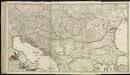
[79][79]Regni Hungariae, ..., uit: Atlas sive Descriptio terrarum orbis
Annotatie: Gedigitaliseerde versie. Amsterdam. Heiloo : Picturae (vervaardiger), 2015. tiff-bestand. Gedigitaliseerd: 07-01-2015; Origineel: Universiteitsbibliotheek Vrije Universiteit (XL.05127.-) ; Netherlands; Titelpagina ontbreekt Wit, Frederik de Amsterdam : Frederick de Wit
Südosteuropa mit den von 1919 bis 1938 geltenden Staatsgrenzen
Südosteuropa Grenzen
Südosteuropa 1991
Südosteuropa, Balkanhalbinsel Kunz, Andreas ; Treiling, Thomas ; Moeschl, Joachim
Südosteuropa 1992
Südosteuropa, Balkanhalbinsel Kunz, Andreas ; Treiling, Thomas ; Moeschl, Joachim
Südosteuropa 1989
Südosteuropa, Balkanhalbinsel Kunz, Andreas ; Treiling, Thomas ; Moeschl, Joachim
Accurate Landkarte Des Königreichs Hungarn des Fürstenthümer Siebenbürge; Moldau und Wallachey, wie auch Griechenlandes und Morea Samt dem Weltberüffnene Donau-Throm
1 : 4000000 Mollova mapová sbírka

Südosteuropa um 1570
Südosteuropa, Osmanisches Reich, Verwaltungsgliederung Zwick, J. ; Koller, M. ; Kreuter, P. M.

Südosteuropa 1806
Südosteuropa, Balkanhalbinsel Kunz, Andreas ; Treiling, Thomas
Südosteuropa 2003
Südosteuropa, Balkanhalbinsel Kunz, Andreas ; Treiling, Thomas ; Moeschl, Joachim
Südosteuropa 1937
Südosteuropa, Balkanhalbinsel Kunz, Andreas ; Treiling, Thomas ; Moeschl, Joachim
Südosteuropa 1947
Südosteuropa, Balkanhalbinsel Kunz, Andreas ; Treiling, Thomas ; Moeschl, Joachim
![Nova totius Hungariae, Transilvaniae, Serviae, Romaniae, Bulgariae, Walachiae, Moldaviae, Sclavoniae, Croatiae, Bosniae, Dalmatiae, maximaeq[ue] partis Danubii fluminis, descriptio / emendata a F. de Wit](https://images-2.georeferencer.com/images/iiif/667157967386/full/,300/0/native.jpg)

