Maps of Central Moravia

III, uit: General-Karte des oesterreichischen Kaiserstaates mit einem grossen Theile der angrenzenden Länder / durch Josef Scheda ... bearb. und hrsg
1 : 576000 Annotatie geografische gegevens: Maatstokken: oesterreichische Meilen, geografische oder deutsche Meilen, preussische Meilen, türkische Berri, französische Lieues, russische Werste; Maatstok per blad: wiener Klafter, öster. Meilen; Blad XIX: statistische en taalkundige informatie; Blad XIX: legenda [Wien : K.K. Militärisch-Geografisches Institut]
Sheet III: Karte Des Oesterreichischen Kaiserstaates.
1 : 576000 Scheda, Josef
Příruční mapa Markrabství moravského a Vévodství slezského
1 : 450000 Brno-oblast (Česko) Wagner, Jan Eduard F. Kytka
Československá republika země Česká a Moravskoslezská

Höhenschichten-Karte von Mähren und Ö. Schlesien
1 : 432000 Morava (Česko) Kořistka, Karel František Edvard Eduard Hölzel
Höhenschichten-Karte von Mähren und Ö. Schlesien
1 : 432000 Morava (Česko) Kořistka, Karel František Edvard Eduard Hölzel
[Das Deutsches Reich, Blatt 4]
Adolf Stieler's Handatlas über alle Theile der Erde und über das Weltgebäude Stieler, Adolf Justus Perthes
[Mähren]
1 : 375000 Morava (Česko) Žitný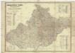
Die Markgrafschaft Maehren mit dem Herzogthume Schlesien
1 : 200000 Morava (Česko) Schenkl, Conrad Philipp Verlag von Carl Winiker
Podrobná mapa země Moravskoslezské
1 : 400000 Brno (Česko) Machát, František Kuchař, Karel V. Neubert a synové
Podrobná mapa země Moravskoslezské
1 : 400000 Brno (Česko) Machát, František V. Neubert a synové
Mapa Horního Slezska a území průplavu dunajsko-odersko-labského
1 : 1250000 Horní Slezsko Slezský kulturní ústav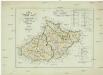
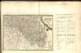
Die Kronländer Mähren und Schlesien nach ihrer neuesten gerichtlichen & politischen Eintheilung
Morava (Česko) Joseph Bermann
Strassen Karte der Margrafschaft Maehren und des Herzogthums Schlesien
1 : 432000 Morava (Česko)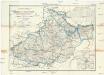
Reisekarte von Mähren und Schlesien mit der Gerichtseintheilung
1 : 450000 Brno (Česko : oblast) Wagner, Jan Eduard Mareš, František F. Kytka
Grossdeutsches Reich Sudetenländer
Dvcatvs Silesiae Tabvla Altera Svperiorem Silesiam =
1 : 575000 Mollova mapová sbírka Hase, Johann Matthias Homann, Johann Baptista - dědici
Die Markgrafschaft Mahren und das Herzogthum Ober- Nieder-Schlesien
1 : 600000 Geographisches Institut (Weimar, Germany)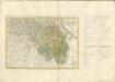

Mähren und Schlesien
1 : 750000 Morava (Česko) Dušek, Č. Paul Sollors' Nachf.
Mähren und Schlesien
1 : 750000 Morava (Česko) Dušek, Č. Paul Sollors' Nachf.
[Carte du relief de le Moravie et de la Silesie par des hachure]
Morava (Česko) Kořistka, Karel František Edvard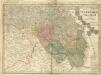
Dvcatvs Silesiae Tabvla Altera Svperiorem Silesiam -
1 : 580000 Mollova mapová sbírka Hase, Johann Matthias Homann, Johann Baptista - dědici
Dvcatvs Silesiae tabvla altera Svperiorem Silesiam
1 : 610000 Horní Slezsko Hase, Johann Matthias Homannianos Heredes
Dvcatvs Silesiae tabvla altera Svperiorem Silesiam exhibens
1 : 610000 Horní Slezsko Hase, Johann Matthias per Homannianos Heredes
Dvcatvs Silesiae tabvla altera Svperiorem Silesiam
1 : 610000 Horní Slezsko Hase, Johann Matthias Homannianos Heredes
Dvcatvs Silesiae tabvla altera Svperiorem Silesiam
1 : 610000 Horní Slezsko Hase, Johann Matthias Homannianos Heredes
Dvcatvs Silesiae tabvla altera Svperiorem Silesiam
1 : 610000 Horní Slezsko Hase, Johann Matthias per Homan[n]ianos Heredes
Dvcatvs Silesiae tabvla altera Svperiorem Silesiam
1 : 610000 Horní Slezsko Hase, Johann Matthias per Homan[n]ianos Heredes


