Maps of Burgenlandkreis

146 Jena, uit: Topographische Special-Karte von Deutschland (von Central-Europa) / begründet von D.G. Reymann ; [entworfen und gezeichn. von Heinrich Berghaus... [et al.]]
1 : 200000 Annotatie: Lit.: Daniel Gottlob Reymann und die "Topographische Special-Karte von Deutschland" / von Wolfgang Scharfe, in: Kartographische Nachrichten, 39 (1989), Heft I, p. 1-10; Handgeschreven titel: Reymann's Deutschland : 24 Sectionen: Jena, Penig, Dresden, Zittau, Hirschberg, Breslau, Brieg, Andernach, Coblenz, Giessen, Fulda, Schleusingen, Plauen, Zwickau, Teplitz, Jung Bunzlau, Hohenelbe, Glatz, Neisse, Simmern, Prag, Luxemburg, Birkenfeld; Aanwezig: 23 bladen Reymann, Daniel Gottlob; Berghaus, Heinrich [Berlin : 2. Departement des Kriegsministeriums, Bureau für Plan- und Kartenzeichnung]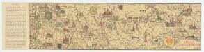
[Kaart], uit: Shell-Saalekarte
1 : 100000 titelvariant: Die Saale; Annotatie: Titel en ondertitel op omslag: Die Saale : von Saalfeld-Weissenfels; Verso: informatie [S.l. : Shell Reisedienst]
Accurate Geographische Delineation Des Stiffts Naumburg und Zeitz
1 : 120000 Mollova mapová sbírka Frankendaal, Nicolaas van Schenk, Peter II
Episcopatus Numburgensis Et Cizensis Delineatio geographica
1 : 120000 Mollova mapová sbírka Lotter, Tobias Conrad Seutter, Matthäus

Das Stifft Naumburg und Zeitz nebst einen grossen Theil derer angraentzenden Laender
1 : 130000 Mollova mapová sbírka Schreiber, Johann Georg Schreiber, Johann Georg
Chorographia Territorii Naumburgo-Citiensis
1 : 90000 Mollova mapová sbírka Schreiber, Johann Georg Homann, Johann Baptista - dědici
Episcopatus Numburgensis...
Jena und Auerstedt 14. Oktober 1806
1 : 300000 Jena Doppelschlacht von Jena und Auerstedt
Accurate Geographische Delineation des Hochs: Sachß. Amtes Weissenfels
1 : 80000 Mollova mapová sbírka Schenk, Pieter Xavery, Gerard Jozeph Schenk, Peter II
Praefecturae Leucopetranae delineatio geographica urbes, oppida, vicos, pagos, limitesque nova ratione complectens exhibita
1 : 80000 Mollova mapová sbírka Seutter, Matthäus Lotter, Tobias Conrad Seutter, Matthäus
Plan des Treffens bey Jena am 14ten October 1806
Geographisches Institut
Plan der Schlacht von Gr. Goerschen den 2ten May 1813
1 : 25000 Brügner, Carl; Jäck; Prêtre, Jean Gabriel Pretre
Meßtischblatt 5139 : Ronneburg, 1942
1 : 250000 Ronneburg. - Aufn. 1906, hrsg. 1909, bericht. 1940. - 1:25000. - Leipzig, 1942. - 1 Kt.
Meßtischblatt 92(3003) : Ronneburg, 1935
1 : 250000 Ronneburg. - Umdr.-Ausg., aufgen. 1906, hrsg. 1909, bericht. 1926, thüring. Teil 1928, einz. Nachtr. 1935. - 1:25000. - Leipzig, 1935. - 1 Kt.
Meßtischblatt 92.(3003) : Rückersdorf (Sächs.) - Ronneburg (Preuß.), 1920
1 : 250000 Rückersdorf (Sächs.) - Ronneburg (Preuß.). - Aufgen. 1906, hrsg. 1909, einz. Nachtr. 1920. - 1:25000. - Leipzig, 1920. - 1 Kt.
Meßtischblatt 92.(3003) : Rückersdorf (Sächs.) - Ronneburg (Preuß.), 1918
1 : 250000 Rückersdorf (Sächs.) - Ronneburg (Preuß.). - Aufgen. 1906, hrsg. 1909, einz. Nachtr. 1918. - 1:25000. - Leipzig, 1918. - 1 Kt.
Meßtischblatt 3002 : Gera, 1928
1 : 250000 Gera. - Hrsg. 1908, bericht. 1928. - 1:25000. - [Berlin]: Reichsamt für Landesaufnahme, 1928. - 1 Kt.
Meßtischblatt 3002 : Gera, 1928
1 : 250000 Gera. - Hrsg. 1908, bericht. 1928. - 1:25000. - [Berlin]: Reichsamt für Landesaufnahme, 1928. - 1 Kt.
Meßtischblatt 91.(3002) : Liebschwitz (Sächs.) - Gera (Preuß.), 1912
1 : 250000 Liebschwitz (Sächs.) - Gera (Preuß.). - Aufgen. 1906, hrsg. 1908,einz. Nachtr. 1912. - 1:25000. - Leipzig, 1912. - 1 Kt.
Meßtischblatt 3001 : Münchenbernsdorf, 1928
1 : 250000 Münchenbernsdorf. - Hrsg. 1908, bericht. 1928. - 1:25000. - [Berlin]: Reichsamt für Landesaufnahme, 1928. - 1 Kt.
Meßtischblatt 3001 : Münchenbernsdorf, 1912
1 : 250000 Münchenbernsdorf. - Aufn. 1906, hrsg. 1908, einz. Nachtr. 1912. - 1:25000. - [Berlin]: Kgl. Preuss. Landesaufnahme, 1912. - 1 Kt.
Meßtischblatt 5135 : Kahla, 1942
1 : 250000 Kahla. - Aufn. 1903, hrsg. 1905, bericht. 1920, letzte Nachtr. 1939. - 1:25000. - [Berlin]: Reichsamt für Landesaufnahme, 1942. - 1 Kt.
Meßtischblatt 5136 : Stadtroda, 1938
1 : 250000 Stadtroda. - Hrsg. 1905, einz. Nachtr. 1938. - 1:25000. - [Berlin]: Reichsamt für Landesaufnahme, 1938. - 1 Kt.
Meßtischblatt 3000 : Roda, 1916
1 : 250000 Roda. - Aufn. 1903, hrsg. 1905, Aufldr. 1916. - 1:25000. - [Berlin]: Reichsamt für Landesaufnahme, 1916. - 1 Kt.
Meßtischblatt 3000 : Roda, 1905
1 : 250000 Roda. - Aufn. 1903. - 1:25000. - [Berlin]: Kgl. Preuss. Landesaufnahme, 1905. - 1 Kt.
Meßtischblatt 3000 : Roda, 1873
1 : 250000 Roda. - Aufn. 1855. - 1:25000. - [Berlin]: Kgl. Preuss. Landesaufnahme, 1873. - 1 Kt.
Meßtischblatt 5135 : Kahla, 1942
1 : 250000 Kahla. - Aufn. 1903, hrsg. 1905, bericht. 1920, letzte Nachtr. 1939. - 1:25000. - [Berlin]: Reichsamt für Landesaufnahme, 1942. - 1 Kt.
Meßtischblatt 2999 : Kahla, 1933
1 : 250000 Kahla. - Hrsg. 1905, bericht. 1920, einz. Nachtr. 1933. - 1:25000. - [Berlin]: Reichsamt für Landesaufnahme, 1933. - 1 Kt.
Meßtischblatt 5134 : Blankenhain, [nach 1945]
1 : 250000 Blankenhain. - Aufn. 1903, hrsg. 1905, bericht. 1931, letzte Nachtr. 1939, hrsg. 1942. - 1:25000. - [Berlin]: Reichsamt für Landesaufnahme, [nach 1945]. - 1 Kt.
![146 Jena, uit: Topographische Special-Karte von Deutschland (von Central-Europa) / begründet von D.G. Reymann ; [entworfen und gezeichn. von Heinrich Berghaus... [et al.]]](https://images-2.georeferencer.com/images/iiif/103254341859/full/,300/0/native.jpg)

