Maps of Mediterranean Sea

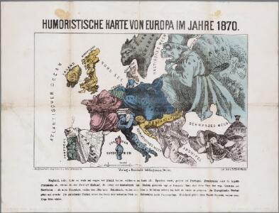
Humoristische Karte von Europa im Jahre 1870
Annotatie: Met toelichting; Karikatuurkaart, zonder auteursvermelding Berlin : Verlag v. Reinhold Schlingmann / (Berlin : Lith. Inst. v. Th. Mettke)
Di-gyiu Du, Ng Da-tsiu Di-du[地舆图、五大洲地图]
Di-gyiu Du, Ng Da-tsiu Di-du[地舆图、五大洲地图] 1853年,Martin, W. A. P. (William Alexander Parsons) 美国长老会传教士丁韪良用罗马拼音标注宁波方言编写的世界地理著作,对地球和各大洲进行介绍。内有东西半球图、亚洲图、欧洲图、非洲图、北美洲图、南美洲图、地中海附近图、清内地十八省图、浙江省图、宁波附近图等。 10图,墨刻本,罗马拼音标注宁波方言,图幅不一,约39 x 49.5 cm Harvard-Yenching | Rare Book | TA 2370 92,Hollis Number:008156153
Map of Europe.
1 : 6300000 Walling, H. F.
Europa
1 : 20000000 Evropa Stein, Carl
Europa
1 : 10500000 Evropa Weiland, Karl Ferdinand Verlag des Geograph. Instituts
Wein-Karte von Europa, oder, Darstelleung derjenigen Laeneder, Provinzen und einzelnen Orte des grössten Theils von Europa
1 : 4500000 Dolní Rakousko (Rakousko) Weiland, Karl Ferdinand Im Verlage des geograpischen Instituts
Europa
1 : 20000000 Evropa Grimm, Johann Ludwig Siebert, Selmar Simon Schropp und Comp. Jäger
Europa
Evropa Schmidt, Johann Marius Friedrich Mare, Carl Simon Schropp
Europa nach den letzten Friedensschlüssen
1 : 20000000 Evropa T. Mollo
Europa
1 : 9000000 Evropa Leichtenstern, Joseph Marx Freiherr von Swoboda, Franz J. Riedel's Kunsthandlung
Neueste Post und General Karte von Europa mit der neuesten Länder Abtheilung des Letzten Friedens Tractate
1 : 3800000 Evropa Spieglin, J. Artaria und Compagnie
Neueste Post und General Karte von Europa mit der neuesten Länder Abtheilung des Letzten Friedens Tractate
1 : 3300000 Evropa Spieglin, J. Artaria und Compagnie
Europe
1 : 20000000 Evropa Society for the Diffusion of Useful knowledge
Europens neuerlichen Republiken
Evropa M., C. A. Lochners, Karl Friedrich
Carte d'Europe dressée pour l'Usage du Roy sur les Itineraires anciens et modernes et sur les Routiers de mer assujetis aux observations astronomiques
1 : 1500000 Evropa Delisle, Guillaume J. Cóvens et C. Mortier
Europa 1555
Europa Kunz, Andreas ; Moeschl, Joachim Robert
9-10. Linee di comunicazione, Europa centrale, Mediterranea.
1 : 8000000 Touring club italiano
Neuer Atlas der ganzen Erde nach den neuesten Bestimmungen für Zeitungsleser
Europe, en 1770
1 : 24000000 Paris : graveé Bte. Tardieu, rue de Bieve, no. 28
Europa
Evropa
Europa seit der französischen Revolution
1 : 11000000 Evropa Geographisches Institut
Europa seit der französischen Revolution
1 : 11000000 Evropa Geographisches Institut
Europa seit der französischen Revolution
1 : 11000000 Evropa Geographisches Institut
Europa seit der französischen Revolution
1 : 11000000 Evropa Geographisches Institut
Europa seit der französischen Revolution
1 : 11000000 Evropa Geographisches Institut
Evropa poly glotta linguarum genealogiam exhibens
1 Karte : Kupferdruck ; 16 x 20 cm Hensel Homännische Erben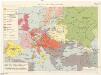
Evropa od r. 1701 do r. 1763
1 : 19350000 Evropa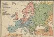
Religionsgebiete von Europa
1 : 36000000 Europa Denomination