Maps of Friesland
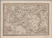
[7], uit: Hydro-Oro und Chorographische General Karte des Koenigreichs der Niederlande und der angrenzenden Länder bis Paris : mit der Angabe der Kunst und Heer-Strassen und der Entfernung der Poststationen / ... zusammengetragen und reducirt von ... Wilhelm Müller
1 : 400000 titelvariant: Generalkarte des Koenigreichs Hannover; Annotatie: 1e supplement bij: Generalkarte des Koenigreichs Hannover (1818) Müller, Wilhelm (fl. 1818) [Hannover : Wilhelm Müller]
La Seigneurie D'Ouest-Frise ou Frise Occidentale, divisée en ses Trois Parties, subdiviseés en leurs Iuridictions. [Karte], in: Atlas nouveau, contenant toutes les parties du monde [...], Bd. 2, S. 89.
1 Karte aus Atlas Sanson, Nicolas Jaillot, Alexis Hubert und Mortier, Pieter
Frisia Occidentalis [Karte], in: Le théâtre du monde, ou, Nouvel atlas contenant les chartes et descriptions de tous les païs de la terre, Bd. 1, S. 444.
1 Karte aus Atlas Blaeu, Willem Janszoon und Blaeu, Joan Blaeu, Willem Janszoon
Frisia Occidentalis [Karte], in: Novus Atlas, das ist, Weltbeschreibung, Bd. 1, S. 411.
1 Karte aus Atlas Blaeu, Joan Blaeu, Willem Janszoon
Frisia Occidentalis [Karte], in: Theatrum orbis terrarum, sive, Atlas novus, Bd. 1, S. 442.
1 Karte aus Atlas Blaeu, Joan Blaeu, Willem Janszoon
Frisiae dominium vernacule Friesland
1 : 130000 Friesland (Německo) Lotter, Tobias Conrad Tob. Conr. Lotter
FRISIA | OCCIDENTALIS
Adriano Metio et Gerardo Freitag | Auctoribus, [Amsterdam : Joan Blaeu]

FRISIA | OCCIDENTALIS
Adriano Metio et Gerardo Freitag | Auctoribus [Amsterdam : Joan Blaeu]
[Kaart], uit: N.O. Nederland
1 : 300000 titelvariant: Groningen, Friesland en Drente; Ten Brink's reiskaart van Groningen, Friesland en Drente; Annotatie: Titel linksonder: Groningen, Friesland en Drente; Omslagtitel: Ten Brink's reiskaart van Groningen, Friesland en Drente : voornamelijk ten dienste van motor-, auto- en wielrijders en voor kantoor en op reis Arnhem : Ten Brink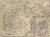
Frisia Occidentalis. [Karte] Antiquae Frisiae situs sub Augusto Imperatore, ut fertur. [Nebenkarten], in: Theatrum orbis terrarum, S. 198.
1 Karte aus Atlas Ortelius, Abraham Vrients, Jan Baptista
DOMINII FRISIAE tabula, inter FLEVUM et LAVICAM
1 : 150000 Frísko Schotanus, Bernhard Visscher, Nicolaes Jansz. ex officina Nicolai Visscher
Frisiae Dominium vernacule Friesland, verdeeld in de hoofd-deelen van Oostergoo, Westergoo en Sevenwolden, als ook der XI steden zynde noch onderscheiden de XXX Grietenijen
1 : 130000 naar de nieuwste afmetingen getekend en uitg. door François Halma, te Leeuwarden. [Leeuwarden] : [François Halma]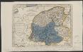
Kaart der doorbraken en overstrooming van Friesland op den 4 february 1825.
1 : 430000 Te Amsterdam : bij E. Maaskamp
Frisiae occidentalis typus.
1 : 400000 [Cornelis Claesz.] [Amsterdam] : [Johannes Janssonius]
[Recto], uit: Frisia Occidentalis / auctoribus Adriano Metio et Gerardo Freitag ; sculpserunt E.S. Hamersveldt et S. Rogeri
1 : 180000 Annotatie: Uit: Gerardi Mercatoris et I. Hondii Atlas ofte Afbeeldinghe vande gantsche Weerldt ... - Amsterdam : Ian Ianssen, 1634 Metius, Adriaan; Freitag, Gerard; Hamersveldt, Everard Symonsz. van; Rogiers, Salomon Amstelodami : Henricus Hondius excudit
Frisia Occidentalis [Karte], in: Novus atlas absolutissimus, Bd. 3, S. 217.
1 Karte aus Atlas Janssonius Offizin
Frisia Occidentalis [Karte], in: Gerardi Mercatoris et I. Hondii Newer Atlas, oder, Grosses Weltbuch, Bd. 1, S. 472.
1 Karte aus Atlas Mercator, Gerhard und Hondius, Jodocus Jansson, Jan
Friesland met de zee ten westen in haar stroomen en zanden nooit dus uitgegeeven
1 : 250000 F. Ottens j[unior] f. [Leeuwarden] : [Hendrik Halma]
Nieuwe kaart van Friesland : behoorende tot het Vaderlandsch woordenboek van Jacobus Kok
1 : 250000 A. v. Krevelt sculpsit, Amsterdam 1781. [S.l.] : [s.n.]
Friesland, uit: Sterfte-atlas van Nederland over 1860-1874 / [uitgave van de Nederlandsche Maatschappij tot Bevordering der Geneeskunst]
titelvariant: Sterfte-atlas van Nederland; Annotatie: Alleen kaartbijlage aanwezig Pieter Harmen Witkamp 1816-1892; Nederlandsche Maatschappij tot Bevordering der Geneeskunst Amsterdam : van Rossen
Tabula Comitatus Frisiae / auctore B. Schotano á Sterringa
1 : 150000 Schotanus à Sterringa, Bernardus Amstelodami : Frederico de Wit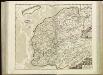
[90][91] Tabula Comitatus Frisiae, uit: Atlas sive Descriptio terrarum orbis
Annotatie: Gedigitaliseerde versie. Amsterdam. Heiloo : Picturae (vervaardiger), 2015. tiff-bestand. Gedigitaliseerd: 07-01-2015; Origineel: Universiteitsbibliotheek Vrije Universiteit (XL.05127.-) ; Netherlands; Titelpagina ontbreekt Wit, Frederik de Amsterdam : Frederick de Wit
Nieuwe kaart van de provincie Friesland
1 : 500000 J.C. de Roeder delin. H. Klockhoff direx. sculp. [Amsterdam] : [Johannes Allart]
Frisia Propria.
1 : 170000 Mollova mapová sbírka Metius, Adrianus Hamersveldt, Everard S. van Janssonius Van Waesberge, Johannes II
Frisia Occidentalis
1 : 170000 Mollova mapová sbírka Metius, Adrianus Blaeu, Willem Jansz.
Domini Frisiae
1 : 150000 Mollova mapová sbírka Schenk, Peter II
Illustribus et Potentibus Frisiae
Mollova mapová sbírka Geelkerken, Nicolaas van Wit, Frederick
Frisia Occidentalis
1 : 240000 Mollova mapová sbírka Merian, Caspar Merian, Caspar
![[7], uit: Hydro-Oro und Chorographische General Karte des Koenigreichs der Niederlande und der angrenzenden Länder bis Paris : mit der Angabe der Kunst und Heer-Strassen und der Entfernung der Poststationen / ... zusammengetragen und reducirt von ... Wilhelm Müller](https://images-2.georeferencer.com/images/iiif/512103521382/full/,300/0/native.jpg)

