Maps of Lansingerland
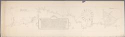
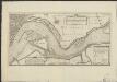
[Kaart van de Rotte door Jan Potter, landmeter]
1 : 4500 Annotatie: Facs. van kaart gemaakt op last van Filips II (1566) wegens een geschil met de familie Van Swieten over het visrecht in de Rotte; Met toelichtende tekst en plattegrond van Rotterdam Potter, Jan Jansz. [S.l. : Corn. Immink]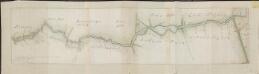
[De Rotte]
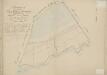
['t Ambacht van Hillegersberg, 't Ambacht van Bleyswijk, Eendragts Droogmakery, Twee Mans Polder]: ... na de metingen, en gedaane opgaven van C. Beket en C. Swieb. Actum Rotterdam 1770. D. Smits,
['t Ambacht van Hillegersberg, 't Ambacht van Bleyswijk, Eendragts Droogmakery, Twee Mans Polder] : ... na de metingen, en gedaane opgaven van C. Beket en C. Swieb. Actum Rotterdam 1770. D. Smits,.
1 : 17000 [Den Haag] : [Landsdrukkerij]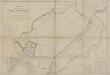
Prins Alexanderpolder, gemeente Hillegersberg, Kralingen, Rotterdam, Capelle a/d IJssel, Nieuwerkerk a/d IJssel en Zevenhuizen.

Polder Kralingen, gemeente Kralingen en Rotterdam.

De drooggemaakte polders van Bleiswijk en een gedeelte van Hillegersberg [Polder Bleiswijk c.a.], gemeente Bleiswijk, Bergschenhoek, Hillegersberg, Rotterdam en Zoetermeer.

Polder Kralingen, gemeente Kralingen en Rotterdam.

Platte grond van Rotterdam : schaal 1:10000
1 : 10000 Claus, J. J uitgave van P.M. Bazendijk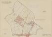
Polder Berg en Broek, gemeente Rotterdam en Berkel en Rodenrijs.

Nieuwe platte grond der stad Rotterdam
1 : 3375 Nijgh, H J. Smulders & C[o]. Lith des Konings's Hague
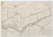
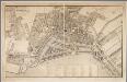
Platte grond der stad Rotterdam en hare omstreken
1 : 10000 opgemaakt volgens de kadastrale kaarten door L.F. Temminck gegraveerd door Dl. Veelwaard en Zoon. Rotterdam : Van der Meer & Verbruggen
Rotterdam
1 : 4700 Arnhem : G.J. Thieme
[Recto], uit: Plattegrond van Rotterdam / geteekend door J.J. Claus
1 : 10000 Claus, J. J. Rotterdam : Bazendijk
Nieuwe platte grond der stad Rotterdam
1 : 5000 Annotatie: Met lijst van gebouwen en 5 stadsgezichten [Rotterdam : Nijgh]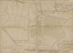
Verenigde polders Schiebroek, Berg en Broek en de 110-Morgen, gemeente Hillegersberg en Schiebroek.

Tabvla Roterdami novissima
Allard, Carel, 1648-ca. 1709 Carolo Allard
Plattegrond van de gemeente Rotterdam, vervaardigd na de uitbreiding aan den linker oever der Maas / door H.C.T. van de Wall ; gravure en kleurendruk van J. Smulders & Cie
1 : 5000 Annotatie: Met lijst van gebouwen Wall, H. C. T. van de; J. Smulders & Cie., 's-Gravenhage Rotterdam : Bazendijk
Nieuwe Platte Grond Vande Stad Rotterdam geleege aand Rivierea de Maase en de Rotte = Plan nouveau de la ville de Rotterdam située sur les Rivieres de la Meuse et de la Rotte
1 : 3923 Leth, Hendrik de, 1703-1766 J. Covens & Zoon
Rotterdam
1 : 16600 Wagner & Debes Geograph. Anstalt von Wagner and Debes
Eendragtspolder, gemeente Zevenhuizen.
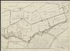
Platte grond der stad Rotterdam / vervaardigd volgens de kadastrale plans ... door L.F. Temminck ; gegraveerd door Dl. Veelwaard en Zonen
1 : 2500 Annotatie: Met lijst van gebouwen en straten; Annotatie geografische gegevens: Noordwest boven Temminck, L. F.; Dl. Veelwaard en Zoon [Rotterdam : Temminck]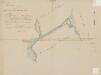
Bovenpolder (Catges en Zwanla) of de Katjes en Zwanlandse polder, gemeente Zevenhuizen.
Gecombineerde polders Capelle a/d IJssel, gemeente Capelle a/d IJssel.
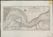
Kaart van de rivier de Maas bij Rotterdam volgens gedaane meeting in Augustus 1791
Kaart van de Merwede of Nieuwe Maas, van den Yssel tot Rotterdam, met de geprojecteerde waterwerken A. B. en C, ter verbetering van dit rivier-vak
Kaart van de Merwede of Nieuwe Maas, van den Yssel tot Rotterdam, met de geprojecteerde waterwerken A. B. en C, ter verbetering van dit rivier-vak
1 : 10000 gepeild en gereduceerd als vooren gemeld door Melchior Bolstra L. Schenk, Jansz sculpsit 1772. [Den Haag] : [Landsdrukkerij]
Deflants Vierentwintichste Stuk: van de Koeckoeks heul, en den Tempel tot de Strik Kade en Swemkoop. En van de Koeckoeks heul en de Hoogh tot over de Lantscheydinge begrypende het Dorp Berckel, Een Deel van de Berckelse, Pynackerse, Ackersdykse en Delfgaeuse Zuyt Polder Zynde het Vysde blat van Delft, het Vierde van Pynacker, het Derde van Berckel en Ruyven, En het Tweelde blat van Rodenrys
Mollova mapová sbírka Cruquius, Nicolaas Samuelszoon Deur, Jacob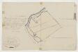
Polder Langeland en Kortland, gemeente Krimpen a/d IJssel.

![[Kaart van de Rotte door Jan Potter, landmeter]](https://images-2.georeferencer.com/images/iiif/001262125869/full/,300/0/native.jpg)

