Maps of Saint-Germain-en-Laye

Flle. 2. Poissy, uit: Carte topographique des environs de Versailles dite "Carte des chasses du Roi"
1 : 28800 titelvariant: Carte des chasses du Roi; Annotatie: Herdruk van originele koperplaten; Oorspr. uitg.: 1764-1807; Voor aanwezige bladen zie overzichtsblad; Annotatie geografische gegevens: Opname: 1764-1773 [Paris : IGN]
La Seine, l'Oise.
1 : 57000 Vincent
Nord-Ouest: Paris Et Ses Environs.
1 : 40000 Service Geologique Des Mines (France)
La Seine.
1 : 54000 Vincent
Composite: Paris Et Ses Environs.
1 : 40000 Service Geologique Des Mines (France)
Paris.
1 : 95000 Colton, G.W.
Paris.
1 : 95000 Colton, G.W.
Camp Retranche de Paris.
1 : 100000 Jouvet et Cie.
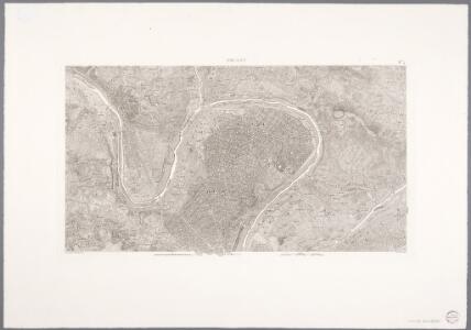
Paris
1 : 80000 Annotatie: Herdruk van originele koperplaat; Oorspr. uitg.: [Paris] : Dépôt de la Guerre, 1832 [Paris : IGN]

Li contorni di Parigi
1 Karte : Kupferdruck ; 26 x 41 cm Zatta presso Antonio Zatta
Nordost Frankreich, Belgien und Luxemburg Deutsche Rheinländer

Carte des environs de Paris, Versailles, St. Germain, et de Poissy
1 Karte : Kupferdruck ; 22 x 33 cm Crépy; Crépy chez Crepy rue S. Jacques à S. Pierre près la rue de la parcheminerie
Environs de Paris dans un rayon de 30 kilomètres
1 : 66670 Antoine E. Andriveau-Goujon
Carte dv pays et forest d'Yveline
1 Karte : Kupferdruck ; 39 x 49 cm Valck; Schenk apud G. Valk et P. Schenk
1 Paris.
1 : 86400 Cassini family; Cassini, Cesar-Francois, 1714-1784
66. Paris, Lorraine, and Saar. The World Atlas.
1 : 250000 USSR (Union of Soviet Socialist Republics).
Plan de Paris XII.
[Paris]
1 Blatt : 60 x 91 cm Bourgoin s.n.
Les environs de Paris
1 Karte : Kupferdruck ; 50 x 73 cm Desnos chez Desnos géographe et ingénieur pour les globes spheres et instruments de mathematiques rue St. Jacques a l'enseigne du globe
Environs de Paris
1 : 25000 Picquet, Charles Ch. Piquet, Géographie ordinaire du Roi et de S.A.S. Monseig.r le Duc d'Orleans
Les environs de Paris
1 : 101000 Paříž-oblast (Francie) Fer, Nicolas de Liébaux de Fer
Ager Parisiensis Vulgo L'Isle De France [Karte], in: Theatrum orbis terrarum, sive, Atlas novus, Bd. 2, S. 19.
1 Karte aus Atlas Blaeu, Joan Blaeu, Willem Janszoon
Carte dv pays Vexin francois
1 : 140500 Valk, Gerhard Schenk, Pieter G. Valk et P. Schenk
Carte pour suivre les opérations du siége de Paris
Paříž (Francie : oblast) Dupont, Paul
AGER PARISIENSIS | Vulgo | L'ISLE DE FRANCE
Fr. Guilloterius Bitur. Viu. describ. | et Cl. V. Petro Pithoeo I.C. | dedicabat Apud Guiljelmum Blaeu
Plan de Paris