Maps of Italy

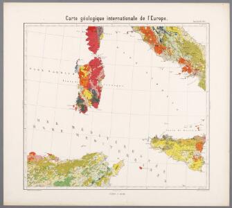
Feuille 38 (C VI), uit: Carte géologique internationale de l'Europe : la carte, votée au congrès géologique international de Bologne en 1881, est exécutée conformément aux décisions d'une commission internationale, avec le concours des gouvernements, sous le dir. de M.M. Beyrich et Hauchecorne
Annotatie: Blad 48 gamme des couleurs; blad 49: bladwijzer en titelblad Heinrich Ernst Beyrich 1815-1896; Wi. Hauchecorne Berlin : Reimer / (Berlin: Institut lithographique)
Tabula Europae VII. [Karte], in: Geographia universalis vetus et nova complectens Claudii Ptolemaei Alexandrini enarrationis libros VIII, S. 242.
1 Karte aus Atlas Münster, Sebastian [und Ptolemaeus, Claudius]
Tabula Europae VII. [Karte], in: Claud. Ptolemaeus. Geographia lat. cum mappis [...], S. 272.
1 Karte aus Atlas Münster, Sebastian [und Ptolemaeus, Claudius]
[Septima Europe tabula] [Karte], in: Clavdii Ptholomei Viri Alexandrini Cosmographie, S. 149.
1 Karte aus Atlas Nicolaus Germanus [und Ptolemaeus, Claudius]
Septima Europe Tabula [Karte], in: [Clavdii Ptholomei Cosmographi ...], S. 275.
1 Karte aus Atlas Nicolaus Germanus [und Ptolemaeus, Claudius]
Regno delle due Sicile con parte degli stati limitrofi
1 : 1270000 Itálie jižní Berra, Marco Tranquillo Mollo
Septima Europe Tabula. [Sardinia Ins. und Sicilia Ins.] [Karte], in: Claudii Ptolemei viri Alexandrini mathematice discipline philosophi doctissimi geographie opus [...], S. 169.
1 Karte aus Atlas Waldseemüller, Martin [und Ptolemaeus, Claudius] Übelin, Georg
Italia
1 : 2500000 Mollova mapová sbírka Delisle, Guillaume Wolff, Jeremias
Italia in suos Statvs divisa et ex prototypo del Isliano de sumta Elementis
1 : 2600000 Mollova mapová sbírka Homann, Johann Baptist Homann, Johann Baptista - dědici
Italien
1 : 200000 Itálie Kiepert, Heinrich Gräf, C. Geographisches Institut
Italien 1866
Italien Kunz, Andreas ; Moeschl, Joachim Robert
Italien Oktober 1797
Italien Kunz, Andreas ; Treiling, Thomas ; Moeschl, Joachim
ITALIA cum Insulis dependentib[us]
1 : 8800000 Itálie
Italy general map.
1 : 3350000 Society for the Diffusion of Useful Knowledge (Great Britain)
L'Italie.
1 : 1500000 Anville, Jean Baptiste Bourguignon d, 1697-1782
Italien 1815
Italien Kunz, Andreas ; Treiling, Thomas ; Moeschl, Joachim
Neueste Karte von Italien
Grosser Hand-Atlas über alle Theile der Erde in 170 Karten Meyer, J. Verlag des Bibliographischen Instituts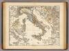
Italia adiectis iis, in quas usque ad Augusti tempus Italiae nomen propagatum est, regionibus, Sicilia, Sardinia, Corsica, quales fuerunt ante adventum Gallorum.
1 : 3900000 Menke, Th.
Italien
Allgemeiner Atlas [Walch, Johannes] im Verlag bei Johannes Walch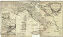
A new map of Italy distinguishing all the sovereignties in it, whether states, kingdoms, dutchies, principalities, republicks & c
1 : 1850000 Cerveteri (Itálie) Moll, Herman
Italien
Volksschul-Atlas über alle Teile der Erde Lange, Henry Druck und Verlag von Georg Westermann
Italien
Geographischer Atlas über alle Theile der Erde Ziegler, Jakob Melchior Verlag von Joh. Wurster um Comp.
Italien mit den k.k. Österreichischen Besitzungen am adriatischen Meere
Geographischer Atlas über alle Theile der Erde Ziegler, Jakob Melchior Verlag von Dietrich Reimer
L'Italie.
1 : 3000000 Andriveau-Goujon, J.
Carta generale dell'Italie e delle provincie austriache sull'Adriatico.
1 : 3000000 Marzolla, Benedetto
Italien
[Allgemeiner Atlas über alle Theile der Erde in 29 Blättern] Ziegler, Jakob Melchior Top. Anstalt v. J. Wurster u. Comp.
Italien
Hypsometrischer Atlas Ziegler, Jakob Melchior Topogr. Anstalt v. J. Wurster u. Comp.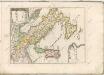

Italie.
1 : 3200000 Levasseur, E.