Maps of Obwalden

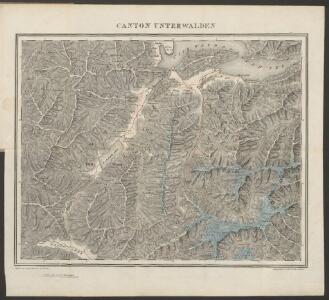
Canton Unterwalden
1 : 125000 Bruder, Carl [Huber]
Relief pittoresque du sol classique de la Suisse
9 Karten dessiné d'après nature et gravé à l'eau forte par Frédéric Guillaume Delkeskamp ; terminé à l'aqua tinta par François Hegi et J.J. Sperli à Zuric = Malerisches Relief des klassischen Bodens der Schweiz / Nach der Natur gezeichnet und radirt von Friedrich Wilhelm Delkeskamp ; in Aqua tinta vollendet von Franz Hegi und J.J. Sperli in Zürich Friedrich Wilhelm Delkeskamp, Frankfurt a/M.
Karte des Kantons Unterwalden
Businger, Josef Maria [Meyer]
Canton Unterwalden sive pagus Helvetiae Subsylvanus cum adjacentibus terrarum tractibus
1 Karte : Kupferdruck ; 45 x 51 cm Walser edentibus Homannianis Heredibus
Canton Unterwalden sive pagus Helvetiae Subsylvanus cum adjacentibus terrarum tractibus
1 Karte : Kupferdruck ; 45 x 51 cm Walser edentibus Homannianis Heredibus
Canton Unterwalden sive Pagus Helvetiae Subsylvanus cum adjacentibus Terrarum Tractibus recenter delineatus
1 : 100000 Mollova mapová sbírka Walser, Gabriel Homann, Johann Baptista - dědici
Karte eines Theiles von Unterwalden und Uri
Leuzinger, Rudolf R. Leuzinger
Excursionskarte Kurhaus Nünalphorn Flühli-Ranft
1 : 100000 Rüegg & Schaufelberger
Brünig-Bahn
1 : 100000 [s.n.]
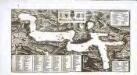
Special-Karte vom Vierwaldstätter See und seinen Umgebungen
1 : 100000 Luzern (Švýcarsko : oblast) Dufour, Henri Guillaume C.F. Prell
Rigi und Urner See
Geologischer Atlas zur Naturgeschichte der Erde Leonhard, Carl Cäsar von E. Schweizerbart'sche Verlagsbuchhandlung

Karte des Vierwaldstättersees & Umgebung
1 : 100000 Luzern (Švýcarsko : oblast) Räber
Carte du Lac de Lucerne ou des Quatre Cantons
1 : 125000 Schmid, Augustin ; Scheuermann, Johann Jakob bey Xav. Meyer
Topographische Karte zum Grenzstreit zwischen Engelberg und Uri
1 : 50000 1 Karte Graph. Anstalt Hofer & Co. [Verlag nicht ermittelbar], [Erscheinungsort nicht ermittelbar]
Karte vom Vierwaldstätter See
1 : 100000 1 Karte Wurster, Winterthur
Plan du lac des IV. cantons, en Suisse
1 Karte : Kupferdruck ; 11 x 25 cm J. und R. Wetstein und William Smith?
Bez titulu: Luzern a okolí
Effigies Quatuor Urbium Silvaticu[m] lacus
1 Karte : Kupferdruck ; 27 x 51 cm Cysat Merian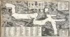
Effigies Quatuor Urbium Silvaticu[m] lacus
1 Karte : Kupferdruck ; 27 x 51 cm Cysat Merian
[Navigation a vapeur sur le Lac des Guatre-Cantons]
Raeber Freres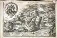
Underwaldia
1 Ansicht : Kupferdruck ; 20 x 30 cm Merian Merian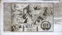
Das Landt Underwalden
1 Vogelschaubild : Kupferdruck ; 15 x 21 cm Kilian Georg Christ. Kilian excudit
Unterwalden - nid dem Wald
1 : 120000 1 Karte J.H. Meyer [Verlag nicht ermittelbar], [Zürich]
Topographische Karte des Kantons Luzern
1 : 25000 Blatt 10 H. Müllhaupt u. Sohn H. Müllhaupt u. Sohn
Topographische Tabelle des untern Amtes der Lucernischen Vogtei Entlibuch
1 Karte : Kupferdruck ; 53 x 44 cm Schnyder von Wartensee; Clausner s.n.
Topographische Tabelle des untern Amtes der Lucernischen Vogtei Entlibuch
1 Karte : Kupferdruck ; 53 x 44 cm Schnyder von Wartensee; Clausner s.n.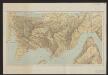
Excursionskarte vom Rigi
1 : 12500 Kartogr. Anstalt von Hofer & Co.
Topographische Karte des Kantons Luzern
1 : 25000 Blatt 8 H. Müllhaupt u. Sohn H. Müllhaupt u. Sohn