Maps of French Polynesia

[Ost-Polynesien]
Hand-Atlas über alle Theile der Erde nach dem neuesten Zustande und über das Weltgebäude Stieler, Adolf bei Justus Perthes
Map of the country between Washington & Pittsburg refering to the contemplated Chesapeake & Ohio Canal and its general route and profile, October 1826 / reduced from the general map annexed to the report upon the comtemplated canal & drawn, b
from Parts
Polynesia, Islands of Pacific.
Letts, Son & Co.
Stille Zuidzee 2 / [getekend door] R. van Wijk ; [naar schetsen van R.G. Bennet en J. van Wijk Roelandsz.]
Dordrecht : J. de Vos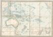
Australien
Amerique Septentrionale 3.
1 : 7500000 Brue, Adrien Hubert, 1786-1832
Mappa geographica Americae Septentrionalis : ad emendatiora exemplaria adhuc edita jussu Acad. reg. scient. et eleg. litt. descripta.
from Charts and maps
Etats-Unis Mexicains, Amerique Centrale.
1 : 9300000 Brue, Adrien Hubert, 1786-1832
West-Indien, Central-Amerika bis zum südlichen Canada in 4 Blättern
1 : 7500000 Südwest-Blatt Petermann, August Heinrich ; Habenicht, H. Justus Perthes
[West-Indien, Central-Amerika bis zum südlichen Canada, Blatt 1]
Adolf Stieler's Handatlas über alle Theile der Erde und über das Weltgebäude Stieler, Adolf Justus Perthes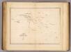
Low Archipelago or Paumotu Group.
1 : 7300000 United States Exploring Expedition (1838-1842)
Hawaiian Group or Sandwich Islands.
1 : 2400000 United States Exploring Expedition (1838-1842)
Mexique et L'Amerique Centrale.
1 : 11000000 Montemont, A.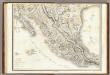
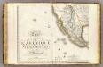
Carte Generale Du Royaume De La Nouvelle Espagne.
1 : 3000000 Humboldt, Alexander von, 1769-1859
L'Ancien et le Nouveau Méxique, avec la Floride et la Basse Louisiane
1 : 10500000 Florida Bonne, Rigobert André
Mexico
1 : 9000000 Mexiko Handtke, Friedrich C. Flemming
Mexico & Guatemala.
1 : 11700000 Tanner, Henry S.
Mexico Guatemala, Salvador and British Honduras
1 : 5274720 Guatemala Edward Stanford
Mexico, Central America.
1 : 14000000 Cornell, S. S. (Sarah S.)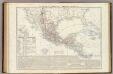
Messico e Stati dell'America Centrale; Istmo di Panama.
1 : 8300000 Marzolla, Benedetto
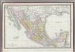
Neueste Karte von Mexico
1 : 9500000 Mexiko Radefeld Bibliographisches Institut
Map of the Mexican Central Railway and connections
1 : 3800000 Poole Brothers Poole Bros., map engravers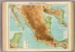
Mexico & Central America.
1 : 5000000 John Bartholomew & Co.
Orographische Skizze des Kaiserthumes Mexico
1 : 6000000 Mexiko Hauslab, Franz von
212-213. Mexico. The World Atlas.
1 : 5000000 USSR (Union of Soviet Socialist Republics).
Mexico und die Republiken von Central -America
1 : 6000000 Mexiko Gräf, C. Eyb, O. von Geographisches Institut
Mexico and Guatemala.
1 : 8400000 Sharpe, J.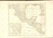
Mexico.
1 : 6400000 Rand McNally and Company
![[Ost-Polynesien]](https://images-2.georeferencer.com/images/iiif/456505442836/full/,300/0/native.jpg)

