Maps of United States Minor Outlying Islands

[Asia-Europa; in Beziehung auf das Fliessende, und seine Vertheilung in Stromgebiete]
Erster Band, enthaltend in vier Abtheilungen die Erscheinungen der anorganischen Natur: 1. Meteorologie und Klimatographie. 2. Hydrologie und Hydrographie. 3. Geologie. 4. Tellurischer Magnetismus Humboldt, Alexander von Verlag von Justus Perthes
Die Volker Asien's Und Europa's.
1 : 30000000 Berghaus, Heinrich
Asien
Geographischer Atlas über alle Theile der Erde Ziegler, Jakob Melchior Verlag von Joh. Wurster um Comp.
[Bergketten in Asien und Europa]
Erster Band, enthaltend in vier Abtheilungen die Erscheinungen der anorganischen Natur: 1. Meteorologie und Klimatographie. 2. Hydrologie und Hydrographie. 3. Geologie. 4. Tellurischer Magnetismus Humboldt, Alexander von Verlag von Justus Perthes
Amerique du Nord spheroidale.
1 : 41000000 Garnier, F. A., 1803-1863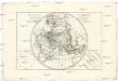
Mappe-monde sur un plan horisontal
Afrika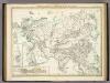
Bergketten In Asien Und Europa.
1 : 21000000 Berghaus, Heinrich
Asia
Schul-Atlas über alle Theile der Erde nach dem neuesten Zustande, und über das Weltgebäude Stieler, Adolf bei Justus Perthes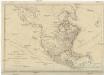
NORTH AMERICA, AS DIVIDED amongst THE EUROPEAN POWERS
Severní Amerika Dunn, Samuel
[Die Völker Asien's und Europa's]
Zweiter Band, enthaltend in vier Abtheilungen die Vertheilung der Organismen: 5. Pflanzen-Geographie, 6. Thier-Geographie, 7. Anthropographie, 8. Ethnographie Humboldt, Alexander von Verlag von Justus Perthes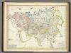
Asia-Europa; in Beziehung auf das Fliessende, und seine Vertheilung in Stromgebiete.
1 : 30000000 Berghaus, Heinrich
Asia and adjacent regions
1 : 15000000 Asie National Geographic Society
Mountain Chains in Asia & Europe
The physical atlas Johnston, Alexander Keith William Blackwood & Sons
Asia secundum legitimas projectionis stereographicae regulas
1 : 26600000 Asie Böhme, August Gottlob Hase, Johann Matthias impensis Homannianorum Hered.
Asia secundum legitimas projectionis stereographicae regulas
1 : 26600000 Asie Hase, Johann Matthias Böhme, August Gottlob impensis Homannianorum Hered.
ASIA
1 : 26600000 Asie Hase, Johann Matthias Böhme, August Gottlob impensis Homannianorum Hered.
Asia
1 : 26600000 Asie Hase, Johann Matthias Böhme, August Gottlob impensis Homannianorum Hered.
North America. Pergamon World Atlas.
1 : 45000000 Polish Army Topography Service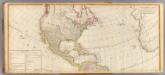
(America north)
1 : 13000000 Robert Laurie & James Whittle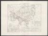
Carta generale di Asia
1 : 25000000 Marzolla, Benedetto Real Litografia Militare
Flusskarte von Asien
Grosser Hand-Atlas über alle Theile der Erde in 170 Karten Meyer, J. Verlag des Bibliographischen Instituts
Bergketten in Asien und Eüropa / Potsdam, gez. u. gest. in der geogr. Kunstschule
1 : 28000000 1 Karte : Kupferdruck ; 32 x 43 cm Berghaus, Heinrich Karl Wilhelm J. Perthes
Recentissima Asiae delineatio, qua imperia, ejus, regna, et status unacum novissimis Russorum detectionib[us] circa Mare Caspium et terram, Yedso alias dict per illor. expedit. et excursiones, factis sistuntur
Asie Homann, Johann Christoph Homann, Johann Baptist Ioh. Christoph. Homanno
Asiae recentissima delineatio, qua status et imperia totius orientis unacum orientalibus Indiis exhibentur
Asie Homann, Johann Baptist J.B. Homann
Verbreitung der vorzuglicheren Saugethiere der Alten Welt.
1 : 50000000 Berghaus, Heinrich

Asien
Asie in der kayserl. privilegirten A.G. Schneider-Weigelschen Kunsthandlung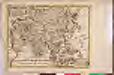
AN ACCURATE MAP OF ASIA

Stromgebiet, Nordamerica.
1 : 31000000 Radefeld, Carl Christian Franz, 1788-1874
![[Asia-Europa; in Beziehung auf das Fliessende, und seine Vertheilung in Stromgebiete]](https://images-2.georeferencer.com/images/iiif/046306221237/full/,300/0/native.jpg)

