Maps of Maryland

Neueste Karte von Maryland und Delaware mit seinen Canaelen, Strassen und Entfernungen der Hauptpunkte
Grosser Hand-Atlas über alle Theile der Erde in 170 Karten Meyer, J. Verlag des Bibliographischen Instituts
A new map of Maryland and Delaware : with their canals, roads & distances / by H.S. Tanner ; E. Gillingham, sc.
from Parts
Philadelphia, Pittsburgh, Richmond, Baltimore-Washington.
Rand McNally and Company
The tourist's pocket map of the state of Virginia: exhibiting its internal improvements, roads, distances, &c. / by J.H. Young; engraved by E. Yeager & F. Dankworth.
from Virginia J. H. Young; E. Yeager; F. Dankworth,
The tourist's pocket map of the state of Virginia: exhibiting its internal improvements, roads, distances, &c. / by J.H. Young; engraved by E. Yeager & F. Dankworth.
from Virginia J. H. Young; E. Yeager; F. Dankworth,
The travellers pocket map of Virginia: with its canals, rail-roads & distances from place to place along the stage roads / by H.S. Tanner; engraved by W. Brose, Philadelphia, 1830.
from Virginia Henry S. Tanner; W. Brose,
Nova Virginiae Tabula [Karte], in: Novus atlas absolutissimus, Bd. 6, S. 207.
1 Karte aus Atlas Janssonius Offizin
A survey of the Northern Neck of Virginia : being the lands belonging to the Rt. Honourable Thomas Lord Fairfax Baron Cameron, bounded by & within the Bay of Chesapoyocke and between the rivers Rappahannock and Potowmack: With the courses of the rive
from Cartographic materials from the Emmet Collection of Manuscripts Etc. Relating to American History.
Nova Virginiae Tabula [Karte], in: Novus Atlas, das ist, Weltbeschreibung, Bd. 2, S. 325.
1 Karte aus Atlas Blaeu, Joan Blaeu, Willem Janszoon
Maryland.
from Carey's general atlas, improved and enlarged : being a collection of maps of the world and quarters, their principal empires, kingdoms, &c.
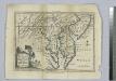
A map of Maryland with the Delaware counties and the southern part of New Jersey &c. / by T. Kitchin, geogr.
from Charts and maps Thomas Kitchin,
Nova Virginiae Tabula [Karte], in: Le théâtre du monde, ou, Nouvel atlas contenant les chartes et descriptions de tous les païs de la terre, Bd. 2, S. 318.
1 Karte aus Atlas Blaeu, Willem Janszoon und Blaeu, Joan Blaeu, Willem Janszoon
A new and accurate map of the province of Virginia in North America.
from Virginia
Shell Highway Map of Delaware - Maryland, Virginia, W. Virginia. (western portion).
1 : 950400 Shell Oil Company
Delaware and Maryland. Baltimore.
1 : 958000 Gray, Ormando Willis
Map to illustrate the 1862 (Virginia) Campaign
Map to illustrate the 1862 (Virginia) Campaign. Map to illustrate the American Civil War of sixty years previously. This small map details the areas of Virginia around the capitals of Washington, D.C. and Richmond where a great amount of fighting took place in 1862 and indeed across the war period. Several places on the map, such as Fredericksburg, Petersburg and Manassas Junction/Bull Run witnessed heavy clashes during the conflict. The map also details railway routes in the region. War Office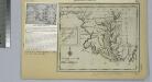
Maryland.
from Maryland
North America: sheet VII, Pennsylvania, New Jersey, Maryland, Delaware, Columbia and part of Virginia / published under the superintendence of the Society for the Diffusion of Useful Knowledge; J. & C. Walker, sculp.
from Parts C. Walker,
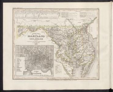
Maryland and Delaware.
1 : 1190000 Tanner, Henry S.
Map Of The Seat Of War.
1 : 633600 Monk, Jacob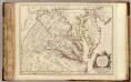
Virginie, Maryland.
1 : 870000 Robert de Vaugondy, Gilles, 1688-1766
NOVA VIRGINIÆ TABVLA
DGrijp Sculpt [Amsterdam : Joan Blaeu]
Delaware and Maryland.
1 : 1000000 Colton, G.W.
Nova Virginiae Tabula [Karte], in: Gerardi Mercatoris et I. Hondii Newer Atlas, oder, Grosses Weltbuch, Bd. 2, S. 392.
1 Karte aus Atlas Mercator, Gerhard und Hondius, Jodocus Jansson, Jan
The new war map of Virginia, Maryland & Pennsylvania
1 : 510000 Russel, B.B. (Benjamin B.)
Nova Virginae Tabula [Karte], in: Theatrum orbis terrarum, sive, Atlas novus, Bd. 2, S. 327.
1 Karte aus Atlas Blaeu, Joan Blaeu, Willem Janszoon
Maryland and Delaware.
1 : 1130000 Mitchell, Samuel Augustus
Maryland and Delaware.
1 : 1130000 Mitchell, Samuel Augustus