Maps of Landkreis Gotha

[Neueste Karte vom Herzogth: Gotha und angränzend: Ländern]
Grosser Hand-Atlas über alle Theile der Erde in 170 Karten Meyer, J. Verlag des Bibliographischen Instituts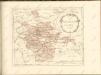

Geognostische Karte des Thüringer Waldes. Nordwestliche Hälfte
1 : 200000 Geognostische Karte des Thüringer Waldes Credner, Heinrich Justus Perthes
Gotha Herzogthum.
1 : 200000 Meyer, Joseph, 1796-1856
Geognostische Uebersichtskarte des Thüringer Waldes
1 : 100000 Beyschlag, Franz ; Pütz, M. Simon Schropp
Der Thüringerwald

127. Gotha, uit: Topographische Uebersichtskarte des Deutschen Reiches / herausgegeben v. d. Kartogr. Abt. d. Königl. Preuß. Landesaufnahme
1 : 200000 titelvariant: Topogr. Übersichtskarte des Deutschen Reiches; Annotatie: Titel boven bladen ook: Topogr. Übersichtskarte des Deutschen Reiches; Annotatie geografische gegevens: Op elk blad twee maatstokken: 10 Kilometer = 5,5 cm; 1 geogr. Meile = 3,6 cm; Legenda onder op elk blad Königlich Preußische Landesaufnahme. Kartographische Abtheilung [S.l : Königlich Preußische Landesaufnahme, Kartographische Abtheilung]
[Recto], uit: Geognostische Übersichtskarte des Thüringer Waldes / F. Beyschlag
1 : 100000 Annotatie: Omslagtitel Franz Heinrich August Beyschlag 1856-1915 [S.l. : s.n.]
Nova Territori[i] Erfordien[sis] in Suas Praefecturas accurate divisi descriptio cui accedit Erfordiae Urbis exterior Facies et Prospectus
1 : 90000 Mollova mapová sbírka Homann, Johann Baptist Homann, Johann Baptista
Landgrafiatvs Hasso-Cassellanvs typo geographico quatuor Foliorum expressus Cura Homannianorum Heredum Norimb: 1761
1 : 160000 Mollova mapová sbírka Homann, Johann Baptist Homann, Johann Baptista - dědici
Carte pour servir de suite a la partie meridionale du landgraviat de Hesse-Cassel avec les pays voisins de la Thuringe
Durynsko (Německo) Brönner, Heinrich Ludwig chez Henry Louis Broenner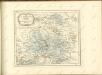


Nova teritorii Erfordien in suas praefecturas accurate divisi descriptio
1 : 90000 Durynsko (Německo) Homann, Johann Baptist Zollmann, Friedrich J.B. Homann
Nova teritorii Erfordien in suas praefecturas
1 : 90000 Durynsko (Německo) Homann, Johann Baptist J. B. Homann

164 Schleusingen, uit: Topographische Special-Karte von Deutschland (von Central-Europa) / begründet von D.G. Reymann ; [entworfen und gezeichn. von Heinrich Berghaus... [et al.]]
1 : 200000 Annotatie: Lit.: Daniel Gottlob Reymann und die "Topographische Special-Karte von Deutschland" / von Wolfgang Scharfe, in: Kartographische Nachrichten, 39 (1989), Heft I, p. 1-10; Handgeschreven titel: Reymann's Deutschland : 24 Sectionen: Jena, Penig, Dresden, Zittau, Hirschberg, Breslau, Brieg, Andernach, Coblenz, Giessen, Fulda, Schleusingen, Plauen, Zwickau, Teplitz, Jung Bunzlau, Hohenelbe, Glatz, Neisse, Simmern, Prag, Luxemburg, Birkenfeld; Aanwezig: 23 bladen Reymann, Daniel Gottlob; Berghaus, Heinrich [Berlin : 2. Departement des Kriegsministeriums, Bureau für Plan- und Kartenzeichnung]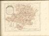

Bez titulu: Soubor plánů – Prusko-Rakouská válka 1866

Gefecht bei Langensalza am 15ten Februar 1761
1 : 25000
Carte von Eisenach und umliegenden Gegend
Sartorius, Georg Christian
Plan de la Ville d'Erford. Capitale de la Thuringe, avec ses deux Citadelles St. Petersberg & Cyriacusberg
1 : 6000 Mollova mapová sbírka Oebschelwitz, L. W. von Hondt, Pierre de
Meßtischblatt 5333 : Bad Blankenburg / Schwarzatal, 1938
1 : 250000 Bad Blankenburg / Schwarzatal. - Hrsg. 1905, bericht. 1934, letzte Nachtr. 1936. - 1:25000. - [Berlin]: Reichsamt für Landesaufnahme, 1938. - 1 Kt.
Meßtischblatt 3122 : Blankenburg / Schwarzatal, 1915
1 : 250000 Blankenburg / Schwarzatal. - Aufn. 1903, hrsg. 1905. - 1:25000. - [Berlin]: Reichsamt für Landesaufnahme, 1915. - 1 Kt.
Meßtischblatt 3122 : Blankenburg / Schwarzatal, 1905
1 : 250000 Blankenburg / Schwarzatal. - Aufn. 1903. - 1:25000. - [Berlin]: Kgl. Preuss. Landesaufnahme, 1905. - 1 Kt.
Meßtischblatt 5332 : Königsee, 1938
1 : 250000 Königsee. - Hrsg. 1905, bericht. 1934. - 1:25000. - [Berlin]: Kgl. Preuss. Landesaufnahme, 1938. - 1 Kt.
Meßtischblatt 3121 : Königsee, 1918
1 : 250000 Königsee. - Aufn. 1903, herausg. 1905. - 1:25000. - [Berlin]: Kgl. Preuss. Landesaufnahme, 1918. - 1 Kt.
Meßtischblatt Königsee
1 : 250000 Königsee. - Aufn. 1903. - 1:25000. - [Berlin]: Kgl. Preuss. Landesaufnahme, 1905. - 1 Kt.
Meßtischblatt 3120, neue Nr. 5331 : Ilmenau, 1938
1 : 250000 Ilmenau. - Aufn. 1903, hrsg. 1905, bericht. 1934, letzte Nachtr. 1936, redakt. Änd. [19]38. - 1:25000. - [Berlin]: Reichsamt für Landesaufnahme, 1938. - 1 Kt.
Meßtischblatt 3120 : Ilmenau, 1919
1 : 250000 Ilmenau. - Aufn. 1903, Nachtr. 1919. - 1:25000. - [Berlin]: Reichsamt für Landesaufnahme, 1919. - 1 Kt.
![[Neueste Karte vom Herzogth: Gotha und angränzend: Ländern]](https://images-2.georeferencer.com/images/iiif/691235351671/full/,300/0/native.jpg)

