Maps of Sahara
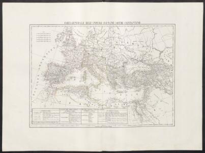
Carta generale dell'impero romano sotto Costantino
1 : 11000000 Marzolla, Benedetto [Verlag nicht ermittelbar]
Europa Antiqua cum finitimis Africae & utriusque Asiae regionibus. [Karte], in: Novus atlas absolutissimus, Bd. 10, S. 33.
1 Karte aus Atlas Janssonius Offizin
Europa antiqua cum finitimis Africæ & utriusque Asiæ regionibus / Nicolaus Blancardus ... delineabat
1 : 10000000 Annotatie: Origineel is Blad 2 in atlas factice Blanckaert, Nicolaas [Amsterdam : Joannes Janssonius]
Verbreitung der Religionen im Anfange von Justinians Regierung
1 : 30000000 Europa Justinian I., Byzantinisches Reich, Kaiser
Ancient Roman empire
J. Dower Henry Teesdale & C
Empire Romain.
1 : 10800000 Andriveau-Goujon, J.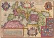
Romani Imperii Imago. [Karte], in: Theatrum orbis terrarum, S. 451.
1 Karte aus Atlas Ortelius, Abraham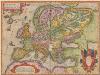
Europam, Sive Celticam Veterem [Karte], in: Theatrum orbis terrarum, S. 362.
1 Karte aus Atlas Ortelius, Abraham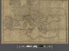
A new map of Europe exhibiting its natural and political divisions drawn from the most recent materials
From Whole
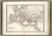
L'Empire Romain.
1 : 10200000 Lapie, M. (Pierre), 1779-1850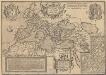
Romani Imperioo Imago. [Karte], in: Theatrum orbis terrarum, S. 450.
1 Karte aus Atlas Ortelius, Abraham Vrients, Jan Baptista
Gemälde der grossen Wanderungen der Barbaren
Historisch-genealogisch-geographischer Atlas von Le Sage Las Cases, Emmanuel Auguste Dieudonné Marius Joseph de Johann Velten, Kunsthändler
Imperium Romanum tempore Constantini Magni

[Übersicht der Verbreitung der wichtigsten Kultur-, Baum- und Strauchgewächse in Europa]
Zweiter Band, enthaltend in vier Abtheilungen die Vertheilung der Organismen: 5. Pflanzen-Geographie, 6. Thier-Geographie, 7. Anthropographie, 8. Ethnographie Humboldt, Alexander von Verlag von Justus Perthes
[Karte von Europa, Zur Übersicht der Regen-Verhältnisse in diesem Erdtheile]
Erster Band, enthaltend in vier Abtheilungen die Erscheinungen der anorganischen Natur: 1. Meteorologie und Klimatographie. 2. Hydrologie und Hydrographie. 3. Geologie. 4. Tellurischer Magnetismus Humboldt, Alexander von Verlag von Justus Perthes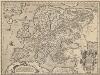
Europam, Sive Celticam Veterem [Karte], in: Theatrum orbis terrarum, S. 453.
1 Karte aus Atlas Ortelius, Abraham Vrients, Jan Baptista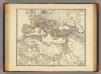
Imperium Romanum inde a bello Actiaco usque ad Diocletiani tempus.
1 : 15000000 Menke, Th.
[Hierographie, oder topographisch-synchronistische Darstellung der Geschichte der christlichen Kirche] : III. Origines - Nicaea
1 : 8400000 W.A. Möller Lith. bey Arnz & Co. in Düsseldorf Elberfeld : Büschler
Übersichts Karte zu den Reisen in Europa, Asien und Afrika unternommen von dem k. k. oesterreich. Bergrathe Joseph Russegger in den Jahren von 1835 bis 1841
1 : 11400000 Afrika E. Schweizerbart'schen Buchhandlung
Übersichts Karte zu den Reisen in Europa, Asien und Afrika unternommen von dem k. k. oesterreich. Bergrathe Joseph Russegger in den Jahren von 1835 bis 1841
1 : 11400000 Afrika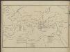
[Hierographie, oder topographisch-synchronistische Darstellung der Geschichte der christlichen Kirche] : I. Zeiten der Apostel
1 : 8400000 W.A. Möller Lith. bey Arnz & Co. in Düsseldorf Elberfeld : Büschler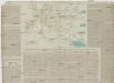
TABLEAU DE LA TRANSMIGRATION DES BARBARES
Evropa Las Cases, Emmanuel-Auguste-Dieudonné Didot, Pierre Jules Didot Ainé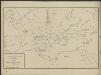
[Hierographie, oder topographisch-synchronistische Darstellung der Geschichte der christlichen Kirche] : II. Von Paulus bis Origines
1 : 8400000 W.A. Möller Lith. bey Arnz & Co. in Düsseldorf Elberfeld : Büschler
[Hierographie, oder topographisch-synchronistische Darstellung der Geschichte der christlichen Kirche] : IV. Von Constantin bis auf Gregor d. G. J. 325-604
1 : 8400000 W.A. Möller Lith. bey Arnz & Co. in Düsseldorf Elberfeld : Büschler
[Hierographie, oder topographisch-synchronistische Darstellung der Geschichte der christlichen Kirche] : VI. Von Constantin bis auf Gregor d. G. J. 325-604
1 : 8400000 W.A. Möller Lith. bey Arnz & Co. in Düsseldorf Elberfeld : Büschler
Europa Post Bellum Triginta Annorum. (1650-1700)
Europa Westfälischer Friede
Europa. Bodengestalt
1 : 24000000 Europa Physische Geografie
Historische Weltkarte
Afrika severní Pařízek, Aleš Vincenc Niederhofer, Ondřej