Maps of Bavaria

Das Königreich Baiern
Allgemeiner Atlas [Walch, Johannes] im Verlag bei Johannes Walch
[Atlas zur Geschichte von Bayern] : VIa. Bayern und die obere Pfalz, mit ihren Theilungen, Erwerbungen und Verlusten, vom XIII bis ins XVI Jahrhundert. VIb. Bayern, Pfalz und Zweybrücken nebst den niederrheinischen Herzogthümern im Jahre 1778
K. v. Spruner Gest. b. Mädel II [Gotha : Perthes]
Karte von Baiern und Schwaben mit einem grossen Theil von Böhmen, Österreich, Salzburg, Steyermark, Kärnten und Krein
Bavorsko (Německo) Artaria
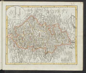
Karte vom Koenigreich Baiern in Kreise eingetheilt
Bavorsko (Německo) Klipstein, A. Walch, Johann bei Joh. Walch
Germaniae Avstriacae Tabula Generalis
1 : 2100000 Mollova mapová sbírka Weigel, Christoph Kauffer, Michael Weigel, Christoph I.
Maiestas Austriaca sive Circul. Archi Ducat.-Austriae :
1 : 1450000 Mollova mapová sbírka Seutter, Matthäus
Maiestas Austriaca sive Circ. Archi Ducat. Austriae
1 : 3400000 Mollova mapová sbírka Seutter, Matthäus Lotter, Tobias Conrad
Germania Austriaca complectens S. R. I. Circulum Austriacum ut et reliquas in Germania Augustissimae Domui Austr. devotas Terras Haereditarias
1 : 1440000 Mollova mapová sbírka Homann, Johann Baptist Homann, Johann Baptista

Leopoldi Magni filio Iosepho I. Avgvsto Romanorvm et Hvng. regi ad capessendum Rhenanae militiae imperium in castra proficiscenti hanc Germaniae Avstriacae generalem tabvlam
1 : 1430000 Evropa střední Homann, Johann Baptist Io. Bapt. Homann
Maiestas Austriaca sive circ. archiducat. Austriae
1 : 3400000 Evropa střední Seutter, Matthäus Lotter, Tobias Conrad Tobias Conrad Lotter
Germania Austriaca completens s. r. i. circulum Austriacum ut et reliquas in Germania augustissimae domui Austr. devotas terras haereditarias
1 : 710000 Evropa střední Homann, Johann Baptist J. B. Homann
Potentia Archiducum Austriae sive circuli Austriaci delineatio
1 : 1550000 Evropa střední Lotter, Tobias Conrad T. C. Lotter
Potentia archiducum Austriae sive circuli Austriaci delineatio, qua illius fines hodierni graphice et accurate exhibentur
1 : 1550000 Evropa střední Lotter, Tobias Conrad impensis Tob. Conradi Lotteri
Potentia archiducum Austriae sive circuli Austriaci delineatio
1 : 1550000 Evropa střední Lotter, Tobias Conrad studio et impensis Tob. Conradi Lotteri
Maiestas Austriaca sive circul. archiducat. Austriae cum ceteris augustissimae huic domui per Germaniam continuo ferme tractu devotis haereditariis terris ob oculos profit
1 : 1450000 Evropa střední Seutter, Matthäus Probst, Johann Michael Ioh. Mich. Probst
Maiestas Austriaca sive circul[us] archiducat[us] Austriae
1 : 1450000 Evropa střední Seutter, Matthäus per Matthaeum Seutterum
Maiestas Austriaca sive circul[us] archiducat[us] Austriae
1 : 1450000 Evropa střední Seutter, Matthäus per Matthaeum Seutterum
Nieuwe kaart van de Beyersche en Oostenryksche Kreits
1 : 2000000 Annotatie: Uit: Nieuwe Hand-Atlas. - Amsterdam : Tirion, 1744 Te Amsterdam : by Isaak Tirion
[Atlas zur Geschichte von Bayern] : VII. Das Königreich Bayern nach seinen gegenwärtigen Bestandtheilen mit allen Gebiets-Veränderungen von 1801 bis 1816
K. v. Spruner W. Hase sc. Weimar [Gotha : Perthes]
Süd-Westliches Deutschland und die Schweiz
Hand-Atlas über alle Theile der Erde und über das Weltgebäude Stieler, Adolf Justus Perthes
Sud-Westliches Deutschland Und Die Schweiz.
1 : 1850000 Vogel, C.
[Atlas zur Geschichte von Bayern] : IV. Die Herzogthümer Baiern, Franken, und ein Theil von Alemannien im XII & XIII Jahrhundert nach erblichen Grafschaften & Gebieten getheilt
K. v. Spruner [Gotha : Perthes]
CHARTE vom KÖNIGREICHE BAYERN
Bavorsko (Německo)
Charte vom Königreiche Bayern
Bavorsko (Německo)
Charte vom Königreiche Bayern
1 : 1040000 Bavorsko (Německo) Güssefeld, Franz L. Ehnlich, I. F. C. im Verlag des Geograph. Instituts
Süd-Westliches Deutschland und die Schweiz
Handatlas über alle Theile der Erde und über das Weltgebäude Stieler, Adolf Justus Perthes
Germany. Deutschland III.
1 : 1760000 Society for the Diffusion of Useful Knowledge (Great Britain)
Raetiae veteris exterae et hodiernae una cum regionibus ei guondam [i.e. quondam] adnumeratis & finitimarum regionum limitibus tabula generalis
1 : 1100000 1 Karte Matth. Hirtzg. ; Leo. Scherer [Joh. Rodolff Wolffen], [Zürich]