Maps of Štědrá

Prassles (Zbrasles) - c9190-1-003 - Kaiserpflichtexemplar der Landkarten des stabilen Katasters
1 : 2880
Prassles (Zbrasles) - c9190-1-002 - Kaiserpflichtexemplar der Landkarten des stabilen Katasters
1 : 2880
Prassles (Zbrasles) - c9190-1-001 - Kaiserpflichtexemplar der Landkarten des stabilen Katasters
1 : 2880
Porostní mapa polesí Luková
1 : 5760
Worka (Borek) - c0379-1-001 - Kaiserpflichtexemplar der Landkarten des stabilen Katasters
1 : 2880
Worka (Borek) - c0379-1-002 - Kaiserpflichtexemplar der Landkarten des stabilen Katasters
1 : 2880
Worka (Borek) - c0379-1-003 - Kaiserpflichtexemplar der Landkarten des stabilen Katasters
1 : 2880
Domaschin (Domarzin) - c1432-1-002 - Kaiserpflichtexemplar der Landkarten des stabilen Katasters
1 : 2880
Domaschin (Domarzin) - c1432-1-003 - Kaiserpflichtexemplar der Landkarten des stabilen Katasters
1 : 2880
Domaschin (Domarzin) - c1432-1-001 - Kaiserpflichtexemplar der Landkarten des stabilen Katasters
1 : 2880
Záměrná mapa lesního celku Vlkošov
1 : 5000
Schaub (Pssowo) - c6270-1-004 - Kaiserpflichtexemplar der Landkarten des stabilen Katasters
1 : 2880
Schaub (Pssowo) - c6270-1-002 - Kaiserpflichtexemplar der Landkarten des stabilen Katasters
1 : 2880
Schaub (Pssowo) - c6270-1-003 - Kaiserpflichtexemplar der Landkarten des stabilen Katasters
1 : 2880
Schaub (Pssowo) - c6270-1-001 - Kaiserpflichtexemplar der Landkarten des stabilen Katasters
1 : 2880
Schaub (Pssowo) - c6270-1-005 - Kaiserpflichtexemplar der Landkarten des stabilen Katasters
1 : 2880
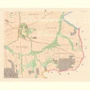
Stiedra (Sstědra) - c7761-1-003 - Kaiserpflichtexemplar der Landkarten des stabilen Katasters
1 : 2880
Stiedra (Sstědra) - c7761-1-002 - Kaiserpflichtexemplar der Landkarten des stabilen Katasters
1 : 2880
Stiedra (Sstědra) - c7761-1-001 - Kaiserpflichtexemplar der Landkarten des stabilen Katasters
1 : 2880
Luckowa (Lukowa) - c4314-1-001 - Kaiserpflichtexemplar der Landkarten des stabilen Katasters
1 : 2880
Luckowa (Lukowa) - c4314-1-002 - Kaiserpflichtexemplar der Landkarten des stabilen Katasters
1 : 2880
[Kartenblatt]
1 : 25000 Rabštejn nad Střelou (Manětín, Česko : oblast) Reichsamt für Landesaufnahme
III. vojenské mapování 3950/4
1 : 25000
Gradkartenblatt
1 : 25000 Žlutice-oblast (Česko) Brück, Josef
Přehledná mapa velkostatku Manětín podle stavu k roku 1905
1 : 37500
Teusinger Vikariat
Toužim-oblast (Česko)
Karlovy Vary
1 : 75000 Bochov (Česko : oblast) Vojenský zeměpisný ústav
Karlovy Vary
1 : 75000 Karlovy Vary-oblast (Česko) Vojenský zeměpisný ústav
III. vojenské mapování 3950
1 : 75000