Maps of Chabařovice

Wiklitz (Wiklice) - c8924-1-001 - Kaiserpflichtexemplar der Landkarten des stabilen Katasters
1 : 2880
Wiklitz (Wiklice) - c8924-1-002 - Kaiserpflichtexemplar der Landkarten des stabilen Katasters
1 : 2880
Wiklitz (Wiklice) - c8924-1-003 - Kaiserpflichtexemplar der Landkarten des stabilen Katasters
1 : 2880
Raudnig - c6562-1-002 - Kaiserpflichtexemplar der Landkarten des stabilen Katasters
1 : 2880
Raudnig - c6562-1-001 - Kaiserpflichtexemplar der Landkarten des stabilen Katasters
1 : 2880
Karbitz - c2464-1-001 - Kaiserpflichtexemplar der Landkarten des stabilen Katasters
1 : 2880
Karbitz - c2464-1-003 - Kaiserpflichtexemplar der Landkarten des stabilen Katasters
1 : 2880
Karbitz - c2464-1-004 - Kaiserpflichtexemplar der Landkarten des stabilen Katasters
1 : 2880
Karbitz - c2464-1-005 - Kaiserpflichtexemplar der Landkarten des stabilen Katasters
1 : 2880
Karbitz - c2464-1-002 - Kaiserpflichtexemplar der Landkarten des stabilen Katasters
1 : 2880
Plan der Gegend bey Linay in Böheim
1 : 32000 Hliňany (Řehlovice, Česko)
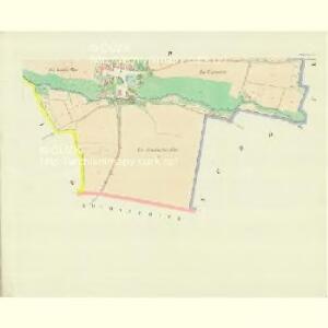
Schönfeld - c8099-1-001 - Kaiserpflichtexemplar der Landkarten des stabilen Katasters
1 : 2880
Schönfeld - c8099-1-002 - Kaiserpflichtexemplar der Landkarten des stabilen Katasters
1 : 2880
Schönfeld - c8099-1-003 - Kaiserpflichtexemplar der Landkarten des stabilen Katasters
1 : 2880
Karte des politischen Bezirkes Aussig

III. vojenské mapování 3752/1
1 : 25000

III. vojenské mapování 3752/1
1 : 25000
III. vojenské mapování 3752/1
1 : 25000
III. vojenské mapování 3752/1
1 : 25000
III. vojenské mapování 3752/1
1 : 25000
[Kartenblatt]
1 : 25000 Krupka (Česko : oblast) Reichsamt für Landesaufnahme
Nollendorf-Kulm 30. August 1813
1 : 300000 Nakléřov Napoleonische Kriege , Schlacht
Teplitz mit seinen Umgebungen
1 : 28800 Teplice-oblast (Česko) Stein, Carl
Die Schlacht bei Kulm am 29. u. 30. August 1813
Chlumec (Ústí nad Labem, Česko) Loquens, Jos. Bormann, E.
Pohlig's Karte von Teplitz und dessen Umgebung
Teplice-oblast (Česko) J.W. Pohlig
Schlacht bei Kulm am 29ten und 30ten August 1813
Vogel von Falckenstein, Eduard; Brose, Karl Heinrich; Prêtre, Jean Gabriel Pretre
Die Herschaft Toeplitz im Leutmeritzer Creisse des Königreichs Boehmen
1 : 80000 Mollova mapová sbírka Zürner, Adam Friedrich Schenk, Peter II
Uibersichtskarte der Aussig Teplitzer Eisenbahn und der in dieselbe einmündenden Zweigbahnen