Maps of Dubeč

Aurzinowes (Auřinowes) - c8196-1-001 - Kaiserpflichtexemplar der Landkarten des stabilen Katasters
1 : 2880
Aurzinowes (Auřinowes) - c8196-1-004 - Kaiserpflichtexemplar der Landkarten des stabilen Katasters
1 : 2880
Aurzinowes (Auřinowes) - c8196-1-005 - Kaiserpflichtexemplar der Landkarten des stabilen Katasters
1 : 2880
Aurzinowes (Auřinowes) - c8196-1-006 - Kaiserpflichtexemplar der Landkarten des stabilen Katasters
1 : 2880
Aurzinowes (Auřinowes) - c8196-1-003 - Kaiserpflichtexemplar der Landkarten des stabilen Katasters
1 : 2880
Aurzinowes (Auřinowes) - c8196-1-002 - Kaiserpflichtexemplar der Landkarten des stabilen Katasters
1 : 2880
Výškopisný plán hlavního města Prahy s okolím

Výškopisný plán hlavního města Prahy s okolím

Pitkowitz (Pitkowice) - c5792-1-002 - Kaiserpflichtexemplar der Landkarten des stabilen Katasters
1 : 2880
Pitkowitz (Pitkowice) - c5792-1-001 - Kaiserpflichtexemplar der Landkarten des stabilen Katasters
1 : 2880
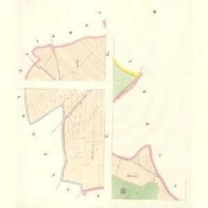
Dubecz - c1584-1-004 - Kaiserpflichtexemplar der Landkarten des stabilen Katasters
1 : 2880
Dubecz - c1584-1-003 - Kaiserpflichtexemplar der Landkarten des stabilen Katasters
1 : 2880
Dubecz - c1584-1-001 - Kaiserpflichtexemplar der Landkarten des stabilen Katasters
1 : 2880
Dubecz - c1584-1-005 - Kaiserpflichtexemplar der Landkarten des stabilen Katasters
1 : 2880
Dubecz - c1584-1-002 - Kaiserpflichtexemplar der Landkarten des stabilen Katasters
1 : 2880
Dubecz - c1584-1-006 - Kaiserpflichtexemplar der Landkarten des stabilen Katasters
1 : 2880
Kralowitz (Kralowice) - c3496-1-003 - Kaiserpflichtexemplar der Landkarten des stabilen Katasters
1 : 2880
Kralowitz (Kralowice) - c3496-1-002 - Kaiserpflichtexemplar der Landkarten des stabilen Katasters
1 : 2880
Kralowitz (Kralowice) - c3496-1-005 - Kaiserpflichtexemplar der Landkarten des stabilen Katasters
1 : 2880
Kralowitz (Kralowice) - c3496-1-004 - Kaiserpflichtexemplar der Landkarten des stabilen Katasters
1 : 2880
Kralowitz (Kralowice) - c3496-1-001 - Kaiserpflichtexemplar der Landkarten des stabilen Katasters
1 : 2880
Benitz (Benice) - c0120-1-002 - Kaiserpflichtexemplar der Landkarten des stabilen Katasters
1 : 2880
Benitz (Benice) - c0120-1-001 - Kaiserpflichtexemplar der Landkarten des stabilen Katasters
1 : 2880
Křeslitz - c3632-1-001 - Kaiserpflichtexemplar der Landkarten des stabilen Katasters
1 : 2880
Křeslitz - c3632-1-002 - Kaiserpflichtexemplar der Landkarten des stabilen Katasters
1 : 2880
Umgebung von Prag
Umgebung von Prag IV.

Karte des Řičaner Bezirkes im Prager Kreise
1 : 70000 Říčany-oblast (Praha-východ, Česko) Wagner, Jan Eduard Karl André
Karte des Řičaner Bezirkes im Prager Kreise
1 : 70000 Říčany-oblast (Praha-východ, Česko) Wagner, Jan Eduard Karl André