Maps of Korozluky

Sedlitz - c6779-1-002 - Kaiserpflichtexemplar der Landkarten des stabilen Katasters
1 : 2880
Sedlitz - c6779-1-001 - Kaiserpflichtexemplar der Landkarten des stabilen Katasters
1 : 2880
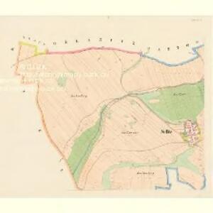
Kollosoruk - c3343-1-001 - Kaiserpflichtexemplar der Landkarten des stabilen Katasters
1 : 2880
Kollosoruk - c3343-1-003 - Kaiserpflichtexemplar der Landkarten des stabilen Katasters
1 : 2880
Kollosoruk - c3343-1-002 - Kaiserpflichtexemplar der Landkarten des stabilen Katasters
1 : 2880
Wtelna - c8916-1-002 - Kaiserpflichtexemplar der Landkarten des stabilen Katasters
1 : 2880
Wtelna - c8916-1-004 - Kaiserpflichtexemplar der Landkarten des stabilen Katasters
1 : 2880
Wtelna - c8916-1-001 - Kaiserpflichtexemplar der Landkarten des stabilen Katasters
1 : 2880
Wtelna - c8916-1-003 - Kaiserpflichtexemplar der Landkarten des stabilen Katasters
1 : 2880
Pattogrö - c5656-1-002 - Kaiserpflichtexemplar der Landkarten des stabilen Katasters
1 : 2880
Pattogrö - c5656-1-001 - Kaiserpflichtexemplar der Landkarten des stabilen Katasters
1 : 2880
Obernitz - c5357-1-001 - Kaiserpflichtexemplar der Landkarten des stabilen Katasters
1 : 2880
Obernitz - c5357-1-002 - Kaiserpflichtexemplar der Landkarten des stabilen Katasters
1 : 2880
Khan - c2473-1-002 - Kaiserpflichtexemplar der Landkarten des stabilen Katasters
1 : 2880
Khan - c2473-1-001 - Kaiserpflichtexemplar der Landkarten des stabilen Katasters
1 : 2880
III. vojenské mapování 3851/2
1 : 25000
[Kartenblatt]
1 : 25000 Bečov (Most, Česko) Reichsamt für Landesaufnahme
[Kartenblatt]
1 : 25000 Bečov (Most, Česko) Reichsamt für Landesaufnahme

Karte der Umgebungen von Brüx, Dux und Oberleutensdorf
1 : 25000 Duchcov-oblast (Česko) Schulz, Josef
Atlas d'industrie de la république tchécoslovaque
[České středohoří - západní část]
Most-oblast (Česko)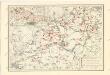
Československo v mapách

Karte der Bezirke Teplitz und Dux
1 : 75000 Duchcov-oblast (Česko) Stelzig, Heinrich Heinrich Stelzig
Karte des politischen Amtsbezirkes Teplitz
1 : 105000 Teplice-oblast (Česko) Fleischer, Albin
Geologische Uebersichtskarte von Teplitz, Bilin, Dux, Brüx un Umgegend
1 : 100000 Teplice-oblast (Česko) Marischler, Norbert Wolf, H. Adolf Becker
Politischer Bezirk Brüx

Most a okolí
1 : 75000 Most (Česko : oblast) Vojenský zeměpisný ústav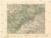
Teplice
1 : 75000 Teplice (Česko : oblast) Vojenský zeměpisný ústav