Maps of Kravaře

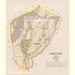
Morgendorf - c6431-1-001 - Kaiserpflichtexemplar der Landkarten des stabilen Katasters
1 : 2880
Johnsdorf - c2762-1-002 - Kaiserpflichtexemplar der Landkarten des stabilen Katasters
1 : 2880
Johnsdorf - c2762-1-001 - Kaiserpflichtexemplar der Landkarten des stabilen Katasters
1 : 2880
Graber - c3543-1-003 - Kaiserpflichtexemplar der Landkarten des stabilen Katasters
1 : 2880
Graber - c3543-1-004 - Kaiserpflichtexemplar der Landkarten des stabilen Katasters
1 : 2880
Graber - c3543-1-001 - Kaiserpflichtexemplar der Landkarten des stabilen Katasters
1 : 2880
Graber - c3543-1-005 - Kaiserpflichtexemplar der Landkarten des stabilen Katasters
1 : 2880
Graber - c3543-1-002 - Kaiserpflichtexemplar der Landkarten des stabilen Katasters
1 : 2880
Zössnitz - c6858-1-002 - Kaiserpflichtexemplar der Landkarten des stabilen Katasters
1 : 2880
Zössnitz - c6858-1-001 - Kaiserpflichtexemplar der Landkarten des stabilen Katasters
1 : 2880
Hermsdorf - c1833-1-002 - Kaiserpflichtexemplar der Landkarten des stabilen Katasters
1 : 2880
Hermsdorf - c1833-1-001 - Kaiserpflichtexemplar der Landkarten des stabilen Katasters
1 : 2880
Hermsdorf - c1833-1-003 - Kaiserpflichtexemplar der Landkarten des stabilen Katasters
1 : 2880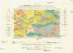
Geologická mapa okolí Kravař a Kozla na západ od České Lípy
1 : 25000 Kravaře (Česká Lípa, Česko) Hibsch, Josef Emanuel Purkyně, Cyrill Státní geologický ústav Československé republiky
III. vojenské mapování 3753/1
1 : 25000
[Kartenblatt]
1 : 25000 Žandov (Česká Lípa, Česko : oblast) Reichsamt für Landesaufnahme

Landkreis Böhm[isch] Leipa
1 : 75000 Protektorát Čechy a Morava Dienststelle für Raumordnung und Landesplanung beim Regierungspräsidenten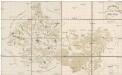
Special Karte des politischen Amtsbezirkes Böhm. Leipa
Česká Lípa-oblast (Česko) Jos. Hamann
Soubor přehledných map pro plánování a statistiku: 3753 – Česká Lípa

III. vojenské mapování 3753
1 : 75000
Česká Lípa
1 : 75000 Bělá pod Bezdězem (Česko : oblast) Vojenský zeměpisný ústav
Č. Lípa
1 : 75000 Čechy (Česko) Vojenský zeměpisný ústav
Podrobná mapa Království českého
1 : 100000 Dubá (Česko : oblast) Srp, Jan Jaroslav Bursík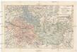
Karte der kais. kön. Bezirkshauptmannschaft Böhm. Leipa
1 : 180000 Česká Lípa-oblast (Česko) Schwarz, Hugo Joh. Künstner
Bhm. Leipa und Dauba
1 : 75000 Dubá (Česko : oblast) Hübner K. u. k. militär-geographisches Institut
Bhm. Leipa und Dauba
1 : 75000 Dubá (Česko : oblast) Hübner K. u. k. Militärgeographisches Institut
B[ö]hm[isch] Leipa und Dauba
1 : 75000 Dubá (Česko : oblast) K. u. k. Militärgeographisches Institut
Specialkarte der böhmisch-sächsischen Schweiz
1 : 75000 Saské Švýcarsko (Německo) Centraalusschuss des Gebirgsvereins für die böhmische Schweiz