Maps of Bělušice

Wodolitz - c5376-1-001 - Kaiserpflichtexemplar der Landkarten des stabilen Katasters
1 : 2880
Wodolitz - c5376-1-003 - Kaiserpflichtexemplar der Landkarten des stabilen Katasters
1 : 2880
Wodolitz - c5376-1-002 - Kaiserpflichtexemplar der Landkarten des stabilen Katasters
1 : 2880
Synutz - c6900-1-002 - Kaiserpflichtexemplar der Landkarten des stabilen Katasters
1 : 2880
Synutz - c6900-1-001 - Kaiserpflichtexemplar der Landkarten des stabilen Katasters
1 : 2880
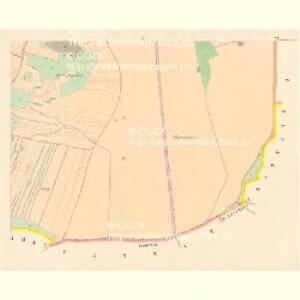
Bieloschitz (Bielossice) - c0202-1-002 - Kaiserpflichtexemplar der Landkarten des stabilen Katasters
1 : 2880
Bieloschitz (Bielossice) - c0202-1-001 - Kaiserpflichtexemplar der Landkarten des stabilen Katasters
1 : 2880
Bieloschitz (Bielossice) - c0202-1-003 - Kaiserpflichtexemplar der Landkarten des stabilen Katasters
1 : 2880
Kosel (Kozlý) - c3457-1-003 - Kaiserpflichtexemplar der Landkarten des stabilen Katasters
1 : 2880
Kosel (Kozlý) - c3457-1-001 - Kaiserpflichtexemplar der Landkarten des stabilen Katasters
1 : 2880
Kosel (Kozlý) - c3457-1-002 - Kaiserpflichtexemplar der Landkarten des stabilen Katasters
1 : 2880
Charwatz - c2475-1-002 - Kaiserpflichtexemplar der Landkarten des stabilen Katasters
1 : 2880
Charwatz - c2475-1-001 - Kaiserpflichtexemplar der Landkarten des stabilen Katasters
1 : 2880
Millay (Miley) - c4635-1-001 - Kaiserpflichtexemplar der Landkarten des stabilen Katasters
1 : 2880
Millay (Miley) - c4635-1-002 - Kaiserpflichtexemplar der Landkarten des stabilen Katasters
1 : 2880
III. vojenské mapování 3851/2
1 : 25000

[Kartenblatt]
1 : 25000 Bečov (Most, Česko) Reichsamt für Landesaufnahme
[Kartenblatt]
1 : 25000 Bečov (Most, Česko) Reichsamt für Landesaufnahme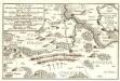
Lager der Kaÿserl. Königl. Ungarischen Armée beÿ Budin in Böhmen vor der Schlacht beÿ Lowositz Anno 1756
Mollova mapová sbírka Fridrich, Jacob Andreas Friedrich, Jacob Andreas
Přehledná mapa rozptýlených lesů mezi polnostmi lesního úřadu Domoušice 1
1 : 34560
Chomutov
1 : 75000 Chomutov-oblast (Česko) Vojenský zeměpisný ústav
Chomutov
1 : 75000 Chomutov (Česko : oblast) Vojenský zeměpisný ústav
Karte des politischen Amtsbezirkes Teplitz
1 : 105000 Teplice-oblast (Česko) Fleischer, Albin
Saaz und Komotau
1 : 75000 Chomutov (Česko : oblast) Fitz, J. K. u. k. militär-geographisches Institut
Saaz und Komotau
1 : 75000 Chomutov (Česko : oblast) Fitz, J. K. u. k. Militärgeographisches Institut
Saaz und Komotau
1 : 75000 Chomutov (Česko : oblast) K. u. k. Militärgeographisches Institut
Přehledná mapa panství a statků Jana Adolfa Schwarzenberga v severozápadních Čechách 1
1 : 50000
Most a okolí
1 : 75000 Most (Česko : oblast) Vojenský zeměpisný ústav