Maps of Dolní Hrachovice

Mostky - c4849-1-001 - Kaiserpflichtexemplar der Landkarten des stabilen Katasters
1 : 2880
Ober Hrachowitz - c2049-1-002 - Kaiserpflichtexemplar der Landkarten des stabilen Katasters
1 : 2880
Ober Hrachowitz - c2049-1-001 - Kaiserpflichtexemplar der Landkarten des stabilen Katasters
1 : 2880
Bendo Zahorzy - c0110-1-001 - Kaiserpflichtexemplar der Landkarten des stabilen Katasters
1 : 2880
Bendo Zahorzy - c0110-1-002 - Kaiserpflichtexemplar der Landkarten des stabilen Katasters
1 : 2880
Rodna - c6493-1-001 - Kaiserpflichtexemplar der Landkarten des stabilen Katasters
1 : 2880
Rodna - c6493-1-003 - Kaiserpflichtexemplar der Landkarten des stabilen Katasters
1 : 2880
Rodna - c6493-1-002 - Kaiserpflichtexemplar der Landkarten des stabilen Katasters
1 : 2880
Gradkartenblatt
1 : 25000 Tábor-oblast (Česko) Gravisi, Karl von
III. vojenské mapování 4253/2
1 : 25000
III. vojenské mapování 4253/2
1 : 25000


Podrobné mapy zemí Koruny české v měřítku 1:75.000 a mapy vzdáleností všech míst při silnici ležících
1 : 75000 Mladá Vožice (Česko : oblast) Bělohlav, Josef F. Topič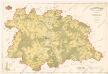
Polohopisná mapa silnic, cest a obecního majetku Táborského

Mapa okolí Tábora
1 : 76000 Tábor-oblast (Česko) Hemmr, Jan Václav Kraus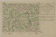
Mapy plánování ČSR

Tábor
1 : 75000 Tábor-oblast (Česko) Vojenský zeměpisný ústav
Tabor
1 : 75000 Bechyně (Česko : oblast) Deppisch K. u. k. militär-geographisches Institut
Tabor
1 : 75000 Bechyně (Česko : oblast) Deppisch K. u. k. Militärgeographisches Institut
Tabor
1 : 75000 Tábor (Česko : oblast) K. u. k. Militärgeographisches Institut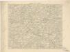
Podrobná místopisná mapa Království Českého

Podrobná mapa Království českého
1 : 100000 Humpolec (Pelhřimov, Česko : oblast) Srp, Jan Jaroslav Bursík
Podrobná místopisná mapa Království Českého

Politický okres Táborský
1 : 100000 Tábor-oblast (Česko) Srp, Jan Schwihlik, F. Jos. R. Vilímek
Selcan und Junc-Woschitz.
from Spezialkarte der osterreichisch-ungarischen Monarchie.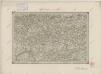
II. vojenské mapování 16
1 : 144000
Kamenitz a./d. Linde (Bohmen).
from Spezialkarte der osterreichisch-ungarischen Monarchie.
Tabor.
from Spezialkarte der osterreichisch-ungarischen Monarchie.


