Maps of Kosoř

Kossorz (Kosoř) - c3361-1-004 - Kaiserpflichtexemplar der Landkarten des stabilen Katasters
1 : 2880
Kossorz (Kosoř) - c3361-1-003 - Kaiserpflichtexemplar der Landkarten des stabilen Katasters
1 : 2880
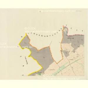
Kossorz (Kosoř) - c3361-1-001 - Kaiserpflichtexemplar der Landkarten des stabilen Katasters
1 : 2880
Kossorz (Kosoř) - c3361-1-002 - Kaiserpflichtexemplar der Landkarten des stabilen Katasters
1 : 2880
Hinter Kopanina (Zadnj Kopanina) - c9026-1-001 - Kaiserpflichtexemplar der Landkarten des stabilen Katasters
1 : 2880
Hinter Kopanina (Zadnj Kopanina) - c9026-1-002 - Kaiserpflichtexemplar der Landkarten des stabilen Katasters
1 : 2880
Hinter Kopanina (Zadnj Kopanina) - c9026-1-003 - Kaiserpflichtexemplar der Landkarten des stabilen Katasters
1 : 2880
[Solopisk und Umgebung]
1 : 9000 Radotín (Praha, Česko) Barrande, Joachim
Okolí zbraslavské
Zbraslav (Praha, Česko)
Radotin - c6394-1-003 - Kaiserpflichtexemplar der Landkarten des stabilen Katasters
1 : 2880
Radotin - c6394-1-005 - Kaiserpflichtexemplar der Landkarten des stabilen Katasters
1 : 2880
Radotin - c6394-1-001 - Kaiserpflichtexemplar der Landkarten des stabilen Katasters
1 : 2880
Radotin - c6394-1-004 - Kaiserpflichtexemplar der Landkarten des stabilen Katasters
1 : 2880
Radotin - c6394-1-002 - Kaiserpflichtexemplar der Landkarten des stabilen Katasters
1 : 2880
Trzebotau (Trzebotow) - c8048-1-002 - Kaiserpflichtexemplar der Landkarten des stabilen Katasters
1 : 2880
Trzebotau (Trzebotow) - c8048-1-003 - Kaiserpflichtexemplar der Landkarten des stabilen Katasters
1 : 2880
Trzebotau (Trzebotow) - c8048-1-001 - Kaiserpflichtexemplar der Landkarten des stabilen Katasters
1 : 2880
Trzebotau (Trzebotow) - c8048-1-004 - Kaiserpflichtexemplar der Landkarten des stabilen Katasters
1 : 2880
Wořech - c5516-1-001 - Kaiserpflichtexemplar der Landkarten des stabilen Katasters
1 : 2880
Wořech - c5516-1-003 - Kaiserpflichtexemplar der Landkarten des stabilen Katasters
1 : 2880
Wořech - c5516-1-002 - Kaiserpflichtexemplar der Landkarten des stabilen Katasters
1 : 2880
Ober-Czernoschitz (Horno-Czernossic) - c2028-1-002 - Kaiserpflichtexemplar der Landkarten des stabilen Katasters
1 : 2880
Ober-Czernoschitz (Horno-Czernossic) - c2028-1-003 - Kaiserpflichtexemplar der Landkarten des stabilen Katasters
1 : 2880
Ober-Czernoschitz (Horno-Czernossic) - c2028-1-001 - Kaiserpflichtexemplar der Landkarten des stabilen Katasters
1 : 2880
Lochkow - c4201-1-002 - Kaiserpflichtexemplar der Landkarten des stabilen Katasters
1 : 2880
Lochkow - c4201-1-001 - Kaiserpflichtexemplar der Landkarten des stabilen Katasters
1 : 2880
Unter-Czernoschitz - c1268-1-002 - Kaiserpflichtexemplar der Landkarten des stabilen Katasters
1 : 2880
Unter-Czernoschitz - c1268-1-001 - Kaiserpflichtexemplar der Landkarten des stabilen Katasters
1 : 2880
Výškopisný plán hlavního města Prahy s okolím