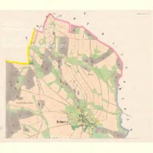
Maps of Chotovice

Kottowitz - c2605-1-001 - Kaiserpflichtexemplar der Landkarten des stabilen Katasters
1 : 2880
Kottowitz - c2605-1-002 - Kaiserpflichtexemplar der Landkarten des stabilen Katasters
1 : 2880
Hayda - c5306-2-001 - Kaiserpflichtexemplar der Landkarten des stabilen Katasters
1 : 2880
Hayda - c5306-2-002 - Kaiserpflichtexemplar der Landkarten des stabilen Katasters
1 : 2880
Projectirtes Laager zwischen dem Böhmisch: Berg, und Schwoiken: Gebürg in den Irgend von Langenau, Kottowitz, Buhl und Kambt
Chotovice (Česká Lípa, Česko)
Langenau (Skalicze) - c6911-1-002 - Kaiserpflichtexemplar der Landkarten des stabilen Katasters
1 : 2880
Langenau (Skalicze) - c6911-1-006 - Kaiserpflichtexemplar der Landkarten des stabilen Katasters
1 : 2880
Langenau (Skalicze) - c6911-1-005 - Kaiserpflichtexemplar der Landkarten des stabilen Katasters
1 : 2880
Langenau (Skalicze) - c6911-1-003 - Kaiserpflichtexemplar der Landkarten des stabilen Katasters
1 : 2880
Langenau (Skalicze) - c6911-1-004 - Kaiserpflichtexemplar der Landkarten des stabilen Katasters
1 : 2880
Langenau (Skalicze) - c6911-1-007 - Kaiserpflichtexemplar der Landkarten des stabilen Katasters
1 : 2880
Langenau (Skalicze) - c6911-1-001 - Kaiserpflichtexemplar der Landkarten des stabilen Katasters
1 : 2880
Pihlerbaustellen (Pihlerbaustelln) - c5764-1-001 - Kaiserpflichtexemplar der Landkarten des stabilen Katasters
1 : 2880
Pihlerbaustellen (Pihlerbaustelln) - c5764-1-003 - Kaiserpflichtexemplar der Landkarten des stabilen Katasters
1 : 2880
Pihlerbaustellen (Pihlerbaustelln) - c5764-1-002 - Kaiserpflichtexemplar der Landkarten des stabilen Katasters
1 : 2880
Bürgstein - c7046-1-002 - Kaiserpflichtexemplar der Landkarten des stabilen Katasters
1 : 2880
Bürgstein - c7046-1-005 - Kaiserpflichtexemplar der Landkarten des stabilen Katasters
1 : 2880
Bürgstein - c7046-1-004 - Kaiserpflichtexemplar der Landkarten des stabilen Katasters
1 : 2880
Bürgstein - c7046-1-001 - Kaiserpflichtexemplar der Landkarten des stabilen Katasters
1 : 2880
Bürgstein - c7046-1-003 - Kaiserpflichtexemplar der Landkarten des stabilen Katasters
1 : 2880

Landkreis Böhm[isch] Leipa
1 : 75000 Protektorát Čechy a Morava Dienststelle für Raumordnung und Landesplanung beim Regierungspräsidenten
Special Karte des politischen Amtsbezirkes Böhm. Leipa
Česká Lípa-oblast (Česko) Jos. Hamann
Karte des Bezirkes Tetschen
Děčín-oblast (Česko) F. Sandtner
Podrobná mapa Království českého
1 : 100000 Dubá (Česko : oblast) Srp, Jan Jaroslav Bursík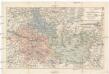
Karte der kais. kön. Bezirkshauptmannschaft Böhm. Leipa
1 : 180000 Česká Lípa-oblast (Česko) Schwarz, Hugo Joh. Künstner
Bhm. Leipa und Dauba
1 : 75000 Dubá (Česko : oblast) Hübner K. u. k. militär-geographisches Institut
Bhm. Leipa und Dauba
1 : 75000 Dubá (Česko : oblast) Hübner K. u. k. Militärgeographisches Institut
B[ö]hm[isch] Leipa und Dauba
1 : 75000 Dubá (Česko : oblast) K. u. k. Militärgeographisches Institut