Maps of Slavošov

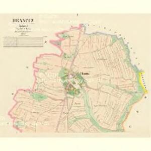
Hranitz - c2333-1-001 - Kaiserpflichtexemplar der Landkarten des stabilen Katasters
1 : 2880
Hranitz - c2333-1-002 - Kaiserpflichtexemplar der Landkarten des stabilen Katasters
1 : 2880
Hodkow - c1927-1-006 - Kaiserpflichtexemplar der Landkarten des stabilen Katasters
1 : 2880
Hodkow - c1927-1-001 - Kaiserpflichtexemplar der Landkarten des stabilen Katasters
1 : 2880
Hodkow - c1927-1-005 - Kaiserpflichtexemplar der Landkarten des stabilen Katasters
1 : 2880
Hodkow - c1927-1-002 - Kaiserpflichtexemplar der Landkarten des stabilen Katasters
1 : 2880
Hodkow - c1927-1-003 - Kaiserpflichtexemplar der Landkarten des stabilen Katasters
1 : 2880
Hodkow - c1927-1-004 - Kaiserpflichtexemplar der Landkarten des stabilen Katasters
1 : 2880
Wostrow - c5557-1-003 - Kaiserpflichtexemplar der Landkarten des stabilen Katasters
1 : 2880
Wostrow - c5557-1-002 - Kaiserpflichtexemplar der Landkarten des stabilen Katasters
1 : 2880
Wostrow - c5557-1-001 - Kaiserpflichtexemplar der Landkarten des stabilen Katasters
1 : 2880
Slawoschow - c7032-1-001 - Kaiserpflichtexemplar der Landkarten des stabilen Katasters
1 : 2880
Slawoschow - c7032-1-003 - Kaiserpflichtexemplar der Landkarten des stabilen Katasters
1 : 2880
Slawoschow - c7032-1-002 - Kaiserpflichtexemplar der Landkarten des stabilen Katasters
1 : 2880
Gradkartenblatt
1 : 25000 Čechy (Česko) Czechák, Carl
III. vojenské mapování 4054/4
1 : 25000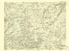
III. vojenské mapování 4054/4
1 : 25000

Podrobné mapy zemí Koruny české v měřítku 1:75.000 a mapa vzdáleností všech míst při silnici ležících - Ledeč - Světlá - Habry. Průvodce statisticko-historický po všech místech na těchto mapách uvedených a rejstřík věcný názvů hor, potoků, řek, rybníků atd. Sešit 23. List 83,
1 : 75000
Podrobné mapy zemí Koruny české v měřítku 1:75.000 a mapy vzdáleností všech míst při silnici ležících
1 : 75000 Habry (Česko) Bělohlav, Josef F. Topič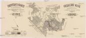
Übersichts-Karte der geleimten Bestände und des aufgeforsteten Nonnengebietes im Reviere Vickovic
1 : 20000 Víckovice (Třebětín, Česko) Němeček, Ad.
Kutná Hora
1 : 75000 Kutná Hora (Česko : oblast) Vojenský zeměpisný ústav
Kuttenberg und Kohljanowitz
1 : 75000 Kutná Hora (Česko : oblast) Kotrtsch K. u. k. militär-geographisches Institut
Kuttenberg und Kohljanowitz
1 : 75000 Kutná Hora (Česko : oblast) Kotrtsch K. u. k. Militärgeographisches Institut
Kuttenberg und Kohljanowitz
1 : 75000 Kutná Hora (Česko : oblast) K. u. k. Militärgeographisches Institut
Mapy plánování ČSR

III. vojenské mapování 4054
1 : 75000
Karte des Gemeindegrenzen

Podrobná mapa Království českého
1 : 100000 Ledeč nad Sázavou (Česko : oblast) Srp, Jan Jaroslav Bursík