Maps of Hrádek nad Nisou

Grottau - c2300-1-004 - Kaiserpflichtexemplar der Landkarten des stabilen Katasters
1 : 2880
Grottau - c2300-1-002 - Kaiserpflichtexemplar der Landkarten des stabilen Katasters
1 : 2880
Grottau - c2300-1-005 - Kaiserpflichtexemplar der Landkarten des stabilen Katasters
1 : 2880
Grottau - c2300-1-003 - Kaiserpflichtexemplar der Landkarten des stabilen Katasters
1 : 2880
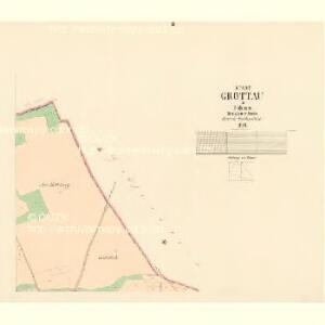
Grottau - c2300-1-001 - Kaiserpflichtexemplar der Landkarten des stabilen Katasters
1 : 2880
Görsdorf - c4242-3-001 - Kaiserpflichtexemplar der Landkarten des stabilen Katasters
1 : 2880
Görsdorf - c4242-3-002 - Kaiserpflichtexemplar der Landkarten des stabilen Katasters
1 : 2880
Görsdorf - c4242-3-003 - Kaiserpflichtexemplar der Landkarten des stabilen Katasters
1 : 2880
Grafenstein - c1713-1-002 - Kaiserpflichtexemplar der Landkarten des stabilen Katasters
1 : 2880
Grafenstein - c1713-1-001 - Kaiserpflichtexemplar der Landkarten des stabilen Katasters
1 : 2880
Grafenstein - c1713-1-003 - Kaiserpflichtexemplar der Landkarten des stabilen Katasters
1 : 2880
Grafenstein - c1713-1-004 - Kaiserpflichtexemplar der Landkarten des stabilen Katasters
1 : 2880
Grafenstein - c1713-1-005 - Kaiserpflichtexemplar der Landkarten des stabilen Katasters
1 : 2880
Döhnis - c1443-1-001 - Kaiserpflichtexemplar der Landkarten des stabilen Katasters
1 : 2880
Döhnis - c1443-1-002 - Kaiserpflichtexemplar der Landkarten des stabilen Katasters
1 : 2880
Döhnis - c1443-1-003 - Kaiserpflichtexemplar der Landkarten des stabilen Katasters
1 : 2880
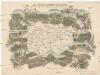
Das böhmisch-sächsische Grenzgebirge
Lužická Nisa-oblast lith. Kunstanstalt von Ed. Strache
Karte der Löbau-Zittauer Eisenbahn
1 : 57000 Lith. v. F.A. Renner
Reichenberg u. Friedland
1 : 75000 Frýdlant (Česko : oblast) Reichenauer K. u. k. Militärgeographisches Institut
Reichenberg u. Friedland
1 : 75000 Frýdlant (Česko : oblast) Reichenauer K. u. k. Militärgeographisches Institut
Reichenberg u[nd] Friedland
1 : 75000 Frýdlant (Česko : oblast) K. u. k. Militärgeographisches Institut
Liberec a okolí
1 : 75000 Liberec (Česko : oblast) Vojenský zeměpisný ústav
Vilímkovy místopisné mapy zemí Koruny české
1 : 100000 Frýdlant (Česko : oblast) Srp, Jan Jos. R. Vilímek
Karte des Bezirkes Reichenberg

Podrobná mapa Království českého
1 : 100000 Frýdlant (Česko : oblast) Srp, Jan Jos. R. Vilímek
Karte der Bezirkshauptmannschaften Reichenberg und Gablonz
1 : 100000 Jablonec nad Nisou-oblast (Česko) Erben, Josef Karl Janský
Section Zittau

Karte des Bezirkes Deutsch-Gabel
1 : 75000 Jablonné v Podještědí-oblast (Česko) Stelzig, Heinrich Freier Lehrervereinim Schulbezirke Deutsch-Gabel