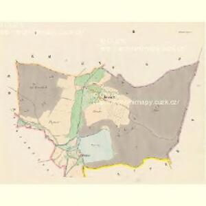
Maps of Stříbrná Skalice

Hradetz (Hradec) - c2287-1-001 - Kaiserpflichtexemplar der Landkarten des stabilen Katasters
1 : 2880
Hradetz (Hradec) - c2287-1-002 - Kaiserpflichtexemplar der Landkarten des stabilen Katasters
1 : 2880
Rev. Woplan
1 : 2200
Skallitz (Skalice) - c7466-1-003 - Kaiserpflichtexemplar der Landkarten des stabilen Katasters
1 : 2880
Skallitz (Skalice) - c7466-1-006 - Kaiserpflichtexemplar der Landkarten des stabilen Katasters
1 : 2880
Skallitz (Skalice) - c7466-1-002 - Kaiserpflichtexemplar der Landkarten des stabilen Katasters
1 : 2880
Skallitz (Skalice) - c7466-1-005 - Kaiserpflichtexemplar der Landkarten des stabilen Katasters
1 : 2880
Skallitz (Skalice) - c7466-1-001 - Kaiserpflichtexemplar der Landkarten des stabilen Katasters
1 : 2880
Skallitz (Skalice) - c7466-1-004 - Kaiserpflichtexemplar der Landkarten des stabilen Katasters
1 : 2880
Skallitz (Skalice) - c7466-1-007 - Kaiserpflichtexemplar der Landkarten des stabilen Katasters
1 : 2880
Woplan - c5493-1-001 - Kaiserpflichtexemplar der Landkarten des stabilen Katasters
1 : 2880
Woplan - c5493-1-002 - Kaiserpflichtexemplar der Landkarten des stabilen Katasters
1 : 2880
Woplan - c5493-1-003 - Kaiserpflichtexemplar der Landkarten des stabilen Katasters
1 : 2880
Kirchen-Strzimelitz(Kostelny Střimelice) - c3385-1-002 - Kaiserpflichtexemplar der Landkarten des stabilen Katasters
1 : 2880
Kirchen-Strzimelitz(Kostelny Střimelice) - c3385-1-001 - Kaiserpflichtexemplar der Landkarten des stabilen Katasters
1 : 2880
Kirchen-Strzimelitz(Kostelny Střimelice) - c3385-1-003 - Kaiserpflichtexemplar der Landkarten des stabilen Katasters
1 : 2880
Mapa politického a školního okresu Českobrodského
III. vojenské mapování 4054/1
1 : 25000
Karte des Schwarzkosteletzer Bezirkes im Prager Kreise
1 : 72000 Kostelec nad Černými lesy-oblast (Česko) Wagner, Jan Eduard Karl André
Mapa okresu Černokosteleckého v Pražském kraji
Kostelec nad Černými lesy (Česko) Kavka, J.
Podrobné mapy zemí Koruny české v měřítku 1:75.000 a mapa vzdáleností všech míst při silnici ležících - Kostelec n/Černými Lesy - Český Šternberk. Průvodce statisticko-historický po všech místech na těchto mapách uvedených a rejstřík věcný názvů hor, potoků, řek, rybníků atd. Sešit 16. List 69,
1 : 75000
Podrobné mapy zemí Koruny české v měřítku 1:75.000 a mapa vzdáleností všech míst při silnici ležících
1 : 75000 Kostelec nad Černými lesy (Česko : oblast) Bělohlav, Josef F. Topič
Mnichowitzer Vicariat
Mnichovice (Benešov, Česko)
Podrobná mapa Království českého
1 : 100000 Ledeč nad Sázavou (Česko : oblast) Srp, Jan Jaroslav Bursík
[Vilímkovy místopisné mapy zemí Koruny české]
1 : 100000 Ledeč nad Sázavou (Česko : oblast) Srp, Jan Jos. R. Vilímek
Politický okres Benešov
1 : 100000 Benešov-oblast (Česko) Kratochvíl, M. Josef Richard Vilímek
Okresní hejtmanství Žižkovské
1 : 100000 Žižkov (Praha, Česko) Srp, Jan Jos. R. Vilímek
[Beneschau und Umgebung]
1 : 144000 Benešov-oblast (Česko) Kořistka, Karel František Edvard