Maps of Dubá

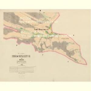
Hirschmantel - c1837-1-001 - Kaiserpflichtexemplar der Landkarten des stabilen Katasters
1 : 2880
Hirschmantel - c1837-1-002 - Kaiserpflichtexemplar der Landkarten des stabilen Katasters
1 : 2880
Sebitsch - c1563-1-002 - Kaiserpflichtexemplar der Landkarten des stabilen Katasters
1 : 2880
Sebitsch - c1563-1-005 - Kaiserpflichtexemplar der Landkarten des stabilen Katasters
1 : 2880
Sebitsch - c1563-1-001 - Kaiserpflichtexemplar der Landkarten des stabilen Katasters
1 : 2880
Sebitsch - c1563-1-004 - Kaiserpflichtexemplar der Landkarten des stabilen Katasters
1 : 2880
Sebitsch - c1563-1-006 - Kaiserpflichtexemplar der Landkarten des stabilen Katasters
1 : 2880
Sebitsch - c1563-1-003 - Kaiserpflichtexemplar der Landkarten des stabilen Katasters
1 : 2880
Lauben - c4233-1-002 - Kaiserpflichtexemplar der Landkarten des stabilen Katasters
1 : 2880
Lauben - c4233-1-001 - Kaiserpflichtexemplar der Landkarten des stabilen Katasters
1 : 2880
III. vojenské mapování 3753/3
1 : 25000
Kays. kön. Cameral ... geometrischer Grund der Dörfen Wocken und Nutznitz
Nučnice (Křešice, Litoměřice, Česko) Aichlburg, Johann von

Straßen-Karte des auton. Bezirkes Dauba
1 : 50000 Dubá (Česko : oblast)
Soubor přehledných map pro plánování a statistiku: 3753 – Česká Lípa

III. vojenské mapování 3753
1 : 75000
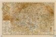
Wandkarte des politischen Bezirkes Dauba

Česká Lípa
1 : 75000 Bělá pod Bezdězem (Česko : oblast) Vojenský zeměpisný ústav
Verbindungs-Dreiecke der Grundlinie zwischen dem Lorenz- und Georgenberge mit der trigonometrischen Vermessung der Gegend um Neuschloss
Petřín (Praha, Česko)
Č. Lípa
1 : 75000 Čechy (Česko) Vojenský zeměpisný ústav
General-Karte der Fideikommiss Herrschaften Münchengraetz, Weiswasser Hirschberg u. Neuperstein
1 : 71200 Bělá pod Bezdězem-oblast (Česko) Placht, W.
Podrobná mapa Království českého
1 : 100000 Dubá (Česko : oblast) Srp, Jan Jaroslav Bursík
Karte der kais. kön. Bezirkshauptmannschaft Böhm. Leipa
1 : 180000 Česká Lípa-oblast (Česko) Schwarz, Hugo Joh. Künstner
Bhm. Leipa und Dauba
1 : 75000 Dubá (Česko : oblast) Hübner K. u. k. militär-geographisches Institut
Bhm. Leipa und Dauba
1 : 75000 Dubá (Česko : oblast) Hübner K. u. k. Militärgeographisches Institut
B[ö]hm[isch] Leipa und Dauba
1 : 75000 Dubá (Česko : oblast) K. u. k. Militärgeographisches Institut
Verbindungs-Dreiecke der Grundlinie zwischen dem Lorenz- und Georgeberge mit der trigonometrischen Vermessung der Gegend um Neuschloss
1 : 230000 Středočeský kraj (Česko : 2000-)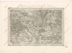
Special - Karte des Koenigreiches Boehmen
Karte der politischen Bezirksverwaltung Böhm. Leipa