Maps of Obrnice

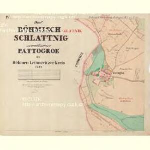
Böhm: Schlattnig - c0978-1-003 - Kaiserpflichtexemplar der Landkarten des stabilen Katasters
1 : 2880
Böhm: Schlattnig - c0978-1-004 - Kaiserpflichtexemplar der Landkarten des stabilen Katasters
1 : 2880
Böhm: Schlattnig - c0978-1-001 - Kaiserpflichtexemplar der Landkarten des stabilen Katasters
1 : 2880
Böhm: Schlattnig - c0978-1-008 - Kaiserpflichtexemplar der Landkarten des stabilen Katasters
1 : 2880
Böhm: Schlattnig - c0978-1-002 - Kaiserpflichtexemplar der Landkarten des stabilen Katasters
1 : 2880
Böhm: Schlattnig - c0978-1-007 - Kaiserpflichtexemplar der Landkarten des stabilen Katasters
1 : 2880
Böhm: Schlattnig - c0978-1-006 - Kaiserpflichtexemplar der Landkarten des stabilen Katasters
1 : 2880
Böhm: Schlattnig - c0978-1-005 - Kaiserpflichtexemplar der Landkarten des stabilen Katasters
1 : 2880
Obernitz - c5357-1-001 - Kaiserpflichtexemplar der Landkarten des stabilen Katasters
1 : 2880
Obernitz - c5357-1-002 - Kaiserpflichtexemplar der Landkarten des stabilen Katasters
1 : 2880
Geologische und Gruben-Revier-Karte des Kohlenbeckens von Teplitz-Dux-Brüx
1 : 10000 Blatt 12 Wolf, Heinrich Lithografie u. Schnell-Pressen-Druck des k.k. Militär-geografischen Institutes
Selnitz - c9389-1-005 - Kaiserpflichtexemplar der Landkarten des stabilen Katasters
1 : 2880
Selnitz - c9389-1-002 - Kaiserpflichtexemplar der Landkarten des stabilen Katasters
1 : 2880
Selnitz - c9389-1-003 - Kaiserpflichtexemplar der Landkarten des stabilen Katasters
1 : 2880
Selnitz - c9389-1-001 - Kaiserpflichtexemplar der Landkarten des stabilen Katasters
1 : 2880
Selnitz - c9389-1-004 - Kaiserpflichtexemplar der Landkarten des stabilen Katasters
1 : 2880
Schwindschitz - c7634-1-002 - Kaiserpflichtexemplar der Landkarten des stabilen Katasters
1 : 2880
Schwindschitz - c7634-1-001 - Kaiserpflichtexemplar der Landkarten des stabilen Katasters
1 : 2880
Pattogrö - c5656-1-002 - Kaiserpflichtexemplar der Landkarten des stabilen Katasters
1 : 2880
Pattogrö - c5656-1-001 - Kaiserpflichtexemplar der Landkarten des stabilen Katasters
1 : 2880
Geologická mapa okolí Bíliny
1 : 25000 Bořeň (České středohoří, Česko : hora) Hibsch, Josef Emanuel Státní geologický ústav Československé republiky
III. vojenské mapování 3751/4
1 : 25000

[Kartenblatt]
1 : 25000 Bílina (Česko : oblast) Reichsamt für Landesaufnahme
[Kartenblatt]
1 : 25000 Bílina (Česko : oblast) Reichsamt für Landesaufnahme
Karte der Umgebungen von Brüx, Dux und Oberleutensdorf
1 : 25000 Duchcov-oblast (Česko) Schulz, Josef
Atlas d'industrie de la république tchécoslovaque
[České středohoří - západní část]
Most-oblast (Česko)
Československo v mapách