Maps of Křivoklát

Czastonitz - c0803-1-001 - Kaiserpflichtexemplar der Landkarten des stabilen Katasters
1 : 2880
Czastonitz - c0803-1-002 - Kaiserpflichtexemplar der Landkarten des stabilen Katasters
1 : 2880
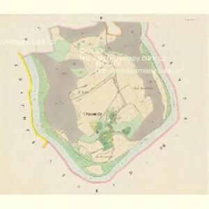
Budda - c3659-1-001 - Kaiserpflichtexemplar der Landkarten des stabilen Katasters
1 : 2880
Augezd-ob-Zbetschno (Augezd n.Zbecznem) - c8230-1-001 - Kaiserpflichtexemplar der Landkarten des stabilen Katasters
1 : 2880
Augezd-ob-Zbetschno (Augezd n.Zbecznem) - c8230-1-003 - Kaiserpflichtexemplar der Landkarten des stabilen Katasters
1 : 2880
Augezd-ob-Zbetschno (Augezd n.Zbecznem) - c8230-1-005 - Kaiserpflichtexemplar der Landkarten des stabilen Katasters
1 : 2880
Augezd-ob-Zbetschno (Augezd n.Zbecznem) - c8230-1-004 - Kaiserpflichtexemplar der Landkarten des stabilen Katasters
1 : 2880
Augezd-ob-Zbetschno (Augezd n.Zbecznem) - c8230-1-002 - Kaiserpflichtexemplar der Landkarten des stabilen Katasters
1 : 2880
Plan des Thiergartner Reviers
1 : 10200 Křivoklát (Česko)
Amalienberg (Amalnj Hora) - c3658-1-001 - Kaiserpflichtexemplar der Landkarten des stabilen Katasters
1 : 2880
Amalienberg (Amalnj Hora) - c3658-1-002 - Kaiserpflichtexemplar der Landkarten des stabilen Katasters
1 : 2880
Amalienberg (Amalnj Hora) - c3658-1-003 - Kaiserpflichtexemplar der Landkarten des stabilen Katasters
1 : 2880
Mapa porostů revírů Nových Mlýnů a Markyty
1 : 14400 Müller, B.
III. vojenské mapování 3952/3
1 : 25000
III. vojenské mapování 3952/3
1 : 25000
Gradkartenblatt
1 : 25000 Křivoklát-oblast (Česko) Albrecht, Julius
Karte des Pürglitzer Bezirkes im Prager Kreise
1 : 72000 Křivoklát-oblast (Česko) Wagner, Jan Eduard in Commission bei Karl André
Karte des Pürglitzer Bezirkes im Prager Kreise
1 : 72000 Křivoklát-oblast (Česko) Wagner, Jan Eduard in Commission bei Karl André
Karte des Pürglitzer Bezirkes im Prager Kreise
1 : 72000 Křivoklát-oblast (Česko) Wagner, Jan Eduard in Commission bei Karl André
Karte des Pürglitzer Bezirkes im Prager Kreise
1 : 72000 Křivoklát-oblast (Česko) Wagner, Jan Eduard in Commission bei Karl André

Situations Plan der Herrschaft Pürglitz und Kruschowitz dann des Gutes Nischburg und Wschetat
Křivoklát-oblast (Česko)
Situations-Plan der Fürst zu Fürstenberg'schen Herrschaft Pürglitz, Kruschowitz, dann des Gutes Nischburg, Wschetatt und Wolleschna etc
1 : 84000 Křivoklát-oblast (Česko) Bohutinský, Friedrich Fürstenberg, Karl Egon
Uibersichts- und Bestandes-Karte des am rechten Ufer des Mies-Flusses gelegenen und zur Domaine Pürglitz gehörigen Waldcomplexes
1 : 70000 Křivoklát-oblast (Česko) Verlag des böhm. Forst-Vereines
Kladno
1 : 75000 Kladno-oblast (Česko) Vojenský zeměpisný ústav
Soubor přehledných map pro plánování a statistiku: 3952 – Kladno

Soubor přehledných map pro plánování a statistiku: 3952 – Kladno

Slanský vikariát
Slaný-oblast (Česko)
III. vojenské mapování 3952
1 : 75000