Maps of Svojkov

Bokven - c0662-1-002 - Kaiserpflichtexemplar der Landkarten des stabilen Katasters
1 : 2880
Bokven - c0662-1-001 - Kaiserpflichtexemplar der Landkarten des stabilen Katasters
1 : 2880
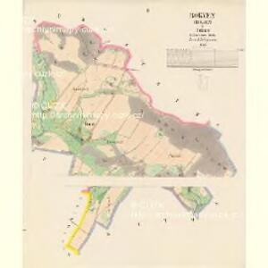
Schwoyka - c7659-1-002 - Kaiserpflichtexemplar der Landkarten des stabilen Katasters
1 : 2880
Schwoyka - c7659-1-001 - Kaiserpflichtexemplar der Landkarten des stabilen Katasters
1 : 2880
Schwoyka - c7659-1-003 - Kaiserpflichtexemplar der Landkarten des stabilen Katasters
1 : 2880
Projectirtes Laager zwischen dem Böhmisch: Berg, und Schwoiken: Gebürg in den Irgend von Langenau, Kottowitz, Buhl und Kambt
Chotovice (Česká Lípa, Česko)
Pihlerbaustellen (Pihlerbaustelln) - c5764-1-001 - Kaiserpflichtexemplar der Landkarten des stabilen Katasters
1 : 2880
Pihlerbaustellen (Pihlerbaustelln) - c5764-1-003 - Kaiserpflichtexemplar der Landkarten des stabilen Katasters
1 : 2880
Pihlerbaustellen (Pihlerbaustelln) - c5764-1-002 - Kaiserpflichtexemplar der Landkarten des stabilen Katasters
1 : 2880
Bürgstein - c7046-1-002 - Kaiserpflichtexemplar der Landkarten des stabilen Katasters
1 : 2880
Bürgstein - c7046-1-005 - Kaiserpflichtexemplar der Landkarten des stabilen Katasters
1 : 2880
Bürgstein - c7046-1-004 - Kaiserpflichtexemplar der Landkarten des stabilen Katasters
1 : 2880
Bürgstein - c7046-1-001 - Kaiserpflichtexemplar der Landkarten des stabilen Katasters
1 : 2880
Bürgstein - c7046-1-003 - Kaiserpflichtexemplar der Landkarten des stabilen Katasters
1 : 2880
Piessnig - c5778-1-002 - Kaiserpflichtexemplar der Landkarten des stabilen Katasters
1 : 2880
Piessnig - c5778-1-001 - Kaiserpflichtexemplar der Landkarten des stabilen Katasters
1 : 2880
Piessnig - c5778-1-003 - Kaiserpflichtexemplar der Landkarten des stabilen Katasters
1 : 2880

[Kartenblatt]
1 : 25000 Žandov (Česká Lípa, Česko : oblast) Reichsamt für Landesaufnahme
Landkreis Böhm[isch] Leipa
1 : 75000 Protektorát Čechy a Morava Dienststelle für Raumordnung und Landesplanung beim Regierungspräsidenten
Special Karte des politischen Amtsbezirkes Böhm. Leipa
Česká Lípa-oblast (Česko) Jos. Hamann
Soubor přehledných map pro plánování a statistiku: 3753 – Česká Lípa

III. vojenské mapování 3753
1 : 75000
Česká Lípa
1 : 75000 Bělá pod Bezdězem (Česko : oblast) Vojenský zeměpisný ústav
Karte des Bezirkes Tetschen
Děčín-oblast (Česko) F. Sandtner
Č. Lípa
1 : 75000 Čechy (Česko) Vojenský zeměpisný ústav
Podrobná mapa Království českého
1 : 100000 Dubá (Česko : oblast) Srp, Jan Jaroslav Bursík
Bhm. Leipa und Dauba
1 : 75000 Dubá (Česko : oblast) Hübner K. u. k. militär-geographisches Institut
Bhm. Leipa und Dauba
1 : 75000 Dubá (Česko : oblast) Hübner K. u. k. Militärgeographisches Institut