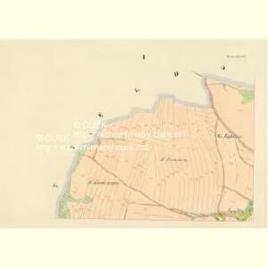
Maps of Bohdaneč

Bohdanetsch (Bohdanec) - c0304-1-003 - Kaiserpflichtexemplar der Landkarten des stabilen Katasters
1 : 2880
Bohdanetsch (Bohdanec) - c0304-1-002 - Kaiserpflichtexemplar der Landkarten des stabilen Katasters
1 : 2880
Bohdanetsch (Bohdanec) - c0304-1-004 - Kaiserpflichtexemplar der Landkarten des stabilen Katasters
1 : 2880
Bohdanetsch (Bohdanec) - c0304-1-001 - Kaiserpflichtexemplar der Landkarten des stabilen Katasters
1 : 2880
Mitteldorf (Prostředniwes) - c6138-1-002 - Kaiserpflichtexemplar der Landkarten des stabilen Katasters
1 : 2880
Mitteldorf (Prostředniwes) - c6138-1-001 - Kaiserpflichtexemplar der Landkarten des stabilen Katasters
1 : 2880
Mitteldorf (Prostředniwes) - c6138-1-003 - Kaiserpflichtexemplar der Landkarten des stabilen Katasters
1 : 2880
Kotautschow (Kotauczow) - c3417-1-003 - Kaiserpflichtexemplar der Landkarten des stabilen Katasters
1 : 2880
Kotautschow (Kotauczow) - c3417-1-001 - Kaiserpflichtexemplar der Landkarten des stabilen Katasters
1 : 2880
Kotautschow (Kotauczow) - c3417-1-002 - Kaiserpflichtexemplar der Landkarten des stabilen Katasters
1 : 2880
Wostrow - c5557-1-003 - Kaiserpflichtexemplar der Landkarten des stabilen Katasters
1 : 2880
Wostrow - c5557-1-002 - Kaiserpflichtexemplar der Landkarten des stabilen Katasters
1 : 2880
Wostrow - c5557-1-001 - Kaiserpflichtexemplar der Landkarten des stabilen Katasters
1 : 2880
Witzkowitz (Wickowic) - c8560-1-003 - Kaiserpflichtexemplar der Landkarten des stabilen Katasters
1 : 2880
Witzkowitz (Wickowic) - c8560-1-004 - Kaiserpflichtexemplar der Landkarten des stabilen Katasters
1 : 2880
Witzkowitz (Wickowic) - c8560-1-002 - Kaiserpflichtexemplar der Landkarten des stabilen Katasters
1 : 2880
Witzkowitz (Wickowic) - c8560-1-001 - Kaiserpflichtexemplar der Landkarten des stabilen Katasters
1 : 2880
Replitz (Řeplic) - c6696-1-002 - Kaiserpflichtexemplar der Landkarten des stabilen Katasters
1 : 2880
Replitz (Řeplic) - c6696-1-003 - Kaiserpflichtexemplar der Landkarten des stabilen Katasters
1 : 2880
Replitz (Řeplic) - c6696-1-001 - Kaiserpflichtexemplar der Landkarten des stabilen Katasters
1 : 2880
Třebetin - c8025-1-001 - Kaiserpflichtexemplar der Landkarten des stabilen Katasters
1 : 2880
Třebetin - c8025-1-002 - Kaiserpflichtexemplar der Landkarten des stabilen Katasters
1 : 2880
Třebetin - c8025-1-003 - Kaiserpflichtexemplar der Landkarten des stabilen Katasters
1 : 2880
Dworetzko - c1625-1-001 - Kaiserpflichtexemplar der Landkarten des stabilen Katasters
1 : 2880
Chlistowitz - c2495-1-001 - Kaiserpflichtexemplar der Landkarten des stabilen Katasters
1 : 2880
Gradkartenblatt
1 : 25000 Čechy (Česko) Czechák, Carl
III. vojenské mapování 4054/4
1 : 25000
III. vojenské mapování 4054/4
1 : 25000