Maps of Kouřim

Regni Bohemiae circulus Kaurzimensis
1 : 205000 Kouřim-oblast (Česko) Müller, Johann Christoph ab Homannianis Heredibus
Regni Bohemiae circulus Kaurzimensis
1 : 205000 Kouřim-oblast (Česko) Müller, Johann Christoph ab Homannianis Heredibus
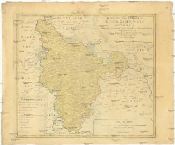
Regni Bohemiae Circulus Kaurzimensis
1 : 180000 Kouřim-oblast (Česko) Müller, Johann Christoph ab Homannianis Heredibus
Kaurzim (Kauřim) - c3428-1-008 - Kaiserpflichtexemplar der Landkarten des stabilen Katasters
1 : 2880
Kaurzim (Kauřim) - c3428-1-001 - Kaiserpflichtexemplar der Landkarten des stabilen Katasters
1 : 2880
Kaurzim (Kauřim) - c3428-1-002 - Kaiserpflichtexemplar der Landkarten des stabilen Katasters
1 : 2880
Kaurzim (Kauřim) - c3428-1-004 - Kaiserpflichtexemplar der Landkarten des stabilen Katasters
1 : 2880
Kaurzim (Kauřim) - c3428-1-007 - Kaiserpflichtexemplar der Landkarten des stabilen Katasters
1 : 2880
Kaurzim (Kauřim) - c3428-1-003 - Kaiserpflichtexemplar der Landkarten des stabilen Katasters
1 : 2880
Kaurzim (Kauřim) - c3428-1-006 - Kaiserpflichtexemplar der Landkarten des stabilen Katasters
1 : 2880
Kaurzim (Kauřim) - c3428-1-005 - Kaiserpflichtexemplar der Landkarten des stabilen Katasters
1 : 2880
Klosterskalitz (Klassternj-Skalice) - c3133-1-001 - Kaiserpflichtexemplar der Landkarten des stabilen Katasters
1 : 2880
Klosterskalitz (Klassternj-Skalice) - c3133-1-002 - Kaiserpflichtexemplar der Landkarten des stabilen Katasters
1 : 2880
Klosterskalitz (Klassternj-Skalice) - c3133-1-003 - Kaiserpflichtexemplar der Landkarten des stabilen Katasters
1 : 2880
Umgebung v. Kauržim
Kouřim-oblast (Česko) Biller, Bernhardt Marco Berra
Lhotta (Lhota) - c1856-1-002 - Kaiserpflichtexemplar der Landkarten des stabilen Katasters
1 : 2880
Lhotta (Lhota) - c1856-1-001 - Kaiserpflichtexemplar der Landkarten des stabilen Katasters
1 : 2880
Boschitz (Bossiče) - c0423-1-003 - Kaiserpflichtexemplar der Landkarten des stabilen Katasters
1 : 2880
Boschitz (Bossiče) - c0423-1-002 - Kaiserpflichtexemplar der Landkarten des stabilen Katasters
1 : 2880
Boschitz (Bossiče) - c0423-1-001 - Kaiserpflichtexemplar der Landkarten des stabilen Katasters
1 : 2880
Tauschitz (Taussice) - c7949-1-003 - Kaiserpflichtexemplar der Landkarten des stabilen Katasters
1 : 2880
Tauschitz (Taussice) - c7949-1-001 - Kaiserpflichtexemplar der Landkarten des stabilen Katasters
1 : 2880
Tauschitz (Taussice) - c7949-1-002 - Kaiserpflichtexemplar der Landkarten des stabilen Katasters
1 : 2880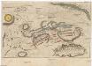
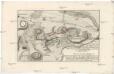
Plan der Bataille ohnweit Planian und Kaurzim bey Chotzemitz welche den 18. Juny 1757 zwischen denen kayserl. königl. hung. böhmisch. und königlich preusischen Arméen vorgefallen, allwo nach 7. mahligem Angriff, die Preusische sich retiriret, und die k. k. das Feld beh[au]ptet
Kolín-oblast (Česko)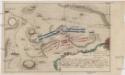
Accurater Plan der Bataille ohnweit Planian und Kaurzim bey dem Dorff Chotzemitz
Kolín-oblast (Česko)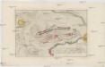
Accurater Plan der Bataille ohnweit Planian und Kaurzim bey dem Dorffe Chotzemitz
Kolín-oblast (Česko)
Plan der Bataille welche den 18. Junii 1757 von der kayserlich königlich-ungarischen und königlich preussischen Armée in Böhmen ohnweit Planian und Collin bey Chotzemitz geliefert worden.
Kolín-oblast (Česko) Čermak, Jan Grale, Conrad
Okres kouřímský [sic]
1 : 37000 Kouřim-oblast (Česko)
Politický okres Kolín
1 : 100000 Kolín (Česko) Josef Richard Vilímek