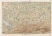
Maps of Regierungsbezirk Tübingen

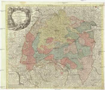
Circulus Suevicus in quo ducatus Wirtenbergensis cum reliquis statibus et provinciis curate designatus propomtur
1 : 640000 Württembersko (Německo) Lotter, Tobias Conrad studio et caelo Tobiae Conradi Lotter
Sect. 26: Augsburg, uit: Geologische Karte des Deutschen Reichs in 27 Blaettern / [von] Richard Lepsius ; Red. von C. Vogel
1 : 500000 Annotatie: Blad 18 ontbreekt; Een aantal bladen op linnen; Een aantal bladen gereviseerd 1913-1914; Annotatie geografische gegevens: Met schaalstokken o.a. in kilometers; Legenda Carl Vogel 1828-1897 Gotha : Justus Perthes
Neue Schweizerkarte von 1847
1 : 300000 1 Karte auf 4 Bl. als Wand- und Reliefkarte topisch und politisch dargestellt von Eduard Winckelmann Tobias Dannheimer, Kempten
Nova Alemanniæ sive Sveviæ svperioris tabvla
1 Karte : Kupferdruck ; 36 x 47 cm Valck; Schenk apud G. Valk et P. Schenk
Constanz - Lindau
1 : 200000 1 Karte entworfen und bearbeitet von Woerl ; in Stein gestochen unter seiner Leitung 1834 ; Lithographie von B. Herder Herder, Freiburg im Breisgau
Alemannia Sive Suevia Superior [Karte], in: Le théâtre du monde, ou, Nouvel atlas contenant les chartes et descriptions de tous les païs de la terre, Bd. 1, S. 266.
1 Karte aus Atlas Blaeu, Willem Janszoon und Blaeu, Joan Blaeu, Willem Janszoon
Nova Alemanniae Sive Sueviae Superioris Tabula. [Karte], in: Gerardi Mercatoris et I. Hondii Newer Atlas, oder, Grosses Weltbuch, Bd. 1, S. 241.
1 Karte aus Atlas Mercator, Gerhard und Hondius, Jodocus Jansson, Jan
ALEMANNIA | SIVE | SVEVIA SVPERIOR
A. Christophoro Hurtero. [Amsterdam : Joan Blaeu]
Alemannia Sive Suevia Superior [Karte], in: Novus Atlas, das ist, Weltbeschreibung, Bd. 1, S. 237.
1 Karte aus Atlas Blaeu, Joan Blaeu, Willem Janszoon
Alemannia sive Svevia svperior / a Christophoro Hurtero
1 : 500000 Annotatie: Origineel is Blad 120 in atlas factice; Annotatie geografische gegevens: Schaalstokken op kaart: Milliaria Alemanica quorum 12 um gradui respondent, en: Milliaria Germanica communia; West boven; Legenda linksonder: Expositio notarum Johann Christoph Hurter; Willem Jansz Blaeu 1571-1638 [Amsterdami] : [apud Guiljelmum Blaeu]
Alemannia Sive Suevia Superior [Karte], in: Theatrum orbis terrarum, sive, Atlas novus, Bd. 1, S. 280.
1 Karte aus Atlas Blaeu, Joan Blaeu, Willem Janszoon
Nova Alemanniae Sive Sueviae Superioris Tabula. [Karte], in: Novus atlas absolutissimus, Bd. 2, S. 217.
1 Karte aus Atlas Janssonius Offizin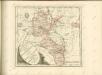

Nova Rhaetiae atque totius Helvetiae descriptio
1 : 350000 1 Karte auf 10 Bl. per Aegidium Tschudum Glaronensem Hofer & Burger, Zürich
[Übersichtskarte von Engadiner Alpen]
1 : 575000 Engadin (Švýcarsko)
Per Inclyti Circuli Suevici Supremorum Ordinum :
1 : 160000 Mollova mapová sbírka Pfeffel, Johann Andreas Homann, Johann Baptista - dědici
Per Inclyti Circuli Suevici Supremorum Ordinum :
1 : 160000 Mollova mapová sbírka Pfeffel, Johann Andreas Pfeffel, Johann Andreas I.
Alemannia sive Suevia Superior
Hurter, Christoph
Nova Alemanniae sive Sveviae Svperioris Tabvla
Hondius, Henricus
[Exactissima Helvetiae, Rhaetiae, Valesiae ... tabula]
1 : 850000 9 Karten [Kopie von Adrian Braakman] [chez Pierre Schenk et Adrian Braakman], [Amsterdam]
Eigentliche Verzeichnuss der Staetten, Grafschaften und Herschaften welche in der Statt Zuerich Gebiet und Landschaft gehoerig sind, 1
2 Blätter : 46 x 71 cm Conrad Orell und Comp.
[Reisekarte der Schweiz]
1 : 500000 1 Karte auf 6 Bl. gezeichnet v. H. Keller ; gest. v. J.J. Scheurmann [Füssli & Comp.], [Zürich]
Geographica provinciarum Sueviae descriptio, 6
6 Blätter : Johann Georg Bodenehr
Landtaflen
1 Atlas [von Johannes Stumpf] Christoffel Froschower, Zürych
Totius s.r.i. circuli Suevici tabula chorographica, 4
1 Blatt : R. et J. Ottens
Alemannia sive Svevia Svperior
1 : 480000 Mollova mapová sbírka Hurter, Johann Christoph Blaeu, Joan I.
Nova Alemanniae sive Svevia Svperioris Tabvla
1 : 490000 Mollova mapová sbírka Hurter, Johann Christoph Janssonius, Johannes I
Schulwandkarte zur Geschichte der Schweiz
1 : 180000 1 Karte auf 6 Bl. bearbeitet v. W. Oechsli u. A. Baldamus ; gezeichnet von Ed. Gaebler Kartograph. Verlagsanstalt von Georg Lang, Leipzig
Alemaniae sive Sveviae Svperioris Chorographia nova
1 : 310000 Mollova mapová sbírka Hurter, Johann Christoph Custos, Raphael