Maps of Rethel

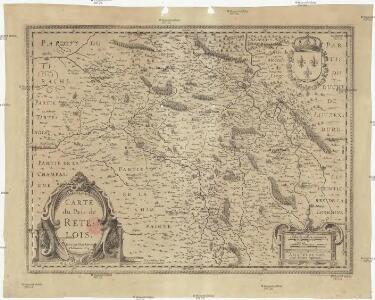
Carte du pais de Retelois
1 : 279000 Jubrien, Jean Janssonius, Johannes apud Ioannem Ianßonium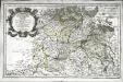
Rhemi
1 Karte : Kupferdruck ; 34 x 54 cm Sanson; Robert de Vaugondy; Perelle chés le Sr. Robert g. du roi quai de l horloge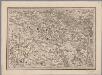
[24], uit: Hydro-Oro und Chorographische General Karte des Koenigreichs der Niederlande und der angrenzenden Länder bis Paris : mit der Angabe der Kunst und Heer-Strassen und der Entfernung der Poststationen / ... zusammengetragen und reducirt von ... Wilhelm Müller
1 : 400000 titelvariant: Generalkarte des Koenigreichs Hannover; Annotatie: 1e supplement bij: Generalkarte des Koenigreichs Hannover (1818) Müller, Wilhelm (fl. 1818) [Hannover : Wilhelm Müller]
Carte du pais de Retelois
1 Karte : Kupferdruck ; 35 x 47 cm Jubrien; Schenk; Valck apud G. Valk et P. Schenk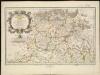
Rhemi : partie septentrle du Dioecse et Archevesché de Rheims en Champagne ...
1 : 211000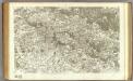
78 Mezieres.
1 : 86400 Cassini family; Cassini, Cesar-Francois, 1714-1784
[Mézières - Sedan]
1 Blatt : 59 x 91 cm Chalmandrier; Le Roy s.n.
La Souveraineté de Sedan et de Raucourt, et la Prevosté de Doncheri. [Karte], in: Gerardi Mercatoris et I. Hondii Newer Atlas, oder, Grosses Weltbuch, Bd. 2, S. 38.
1 Karte aus Atlas Mercator, Gerhard und Hondius, Jodocus Jansson, Jan
Les Souverainetez De Sedan Et de Raucourt, Et La Prevosté De Doncheri. [Karte], in: Theatrum orbis terrarum, sive, Atlas novus, Bd. 2, S. 44.
1 Karte aus Atlas Blaeu, Joan Blaeu, Willem Janszoon
Les Souverainetez De Sedan Et De Raucourt Et La Prevosté De Doncheri. [Karte], in: Le théâtre du monde, ou, Nouvel atlas contenant les chartes et descriptions de tous les païs de la terre, Bd. 2, S. 63.
1 Karte aus Atlas Blaeu, Willem Janszoon und Blaeu, Joan Blaeu, Willem Janszoon

Les Souverainetez de Sedan et Raucourt et la Prevosté de Doncheri
1 : 25344
La Souveraineté de Sedan et de Raucourt et la Prevosté de Doncheri. [Karte], in: Novus atlas absolutissimus, Bd. 4, S. 74.
1 Karte aus Atlas Janssonius Offizin
LES SOVVERAINETEZ DE | SEDAN ET DE RAVCOVRT | ET LA PREVOSTÉ DE | DONCHERI
AMSTERDAMI | Apud Guiljelmum Blaeuw
Les Souverainetez De Sedan Et De Raucourt Et La Prevosté De Doncheri. [Karte], in: Novus Atlas, das ist, Weltbeschreibung, Bd. 2, S. 63.
1 Karte aus Atlas Blaeu, Joan Blaeu, Willem Janszoon
Les sovverainetez de Sedan et de Ravcovrt et la prevosté de Doncheri
1 Karte : Kupferdruck ; 36 x 48 cm Blaeu apud Guiljelmum Blaeuw
La sovveraineté de Sedan et de Ravcovrt, et la prevosté de Doncheri
1 Karte : Kupferdruck ; 36 x 49 cm Tavernier; Hondius excusum apud Henricum Hondium habitantem supra damum sub insigno Atlantis, chez Melchior Tauernier demeurant sur l'isle du Palais
Gruppe Sissonne
1 : 25000 Pikardie (Francie) Vermessungs-Abteilung 14
Skizze zum Gefechte bei Voncq am Abend des 29.8.70
1 : 80000
Brimont S. O.

Zusammendruck Berrieux
1 : 10000 Pikardie (Francie) Vermessungs-Abteilung 14
Stenay
Mollova mapová sbírka Merian, Matthaeus Merian, Matthäus - dědici
Stenay
Mollova mapová sbírka Merian, Matthaeus Merian, Matthäus - dědici
Winterberg
1 : 1500 Pikardie (Francie) Vermessungs-Abteilung 14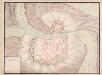
A colored plan of Charleville
A colored manuscript plan of Charleville in Ardennes, France; drawn about 1700, on a scale of [60 toises] to an inch.
Carte du Pais de Retelois. [Karte], in: Gerardi Mercatoris et I. Hondii Newer Atlas, oder, Grosses Weltbuch, Bd. 2, S. 35.
1 Karte aus Atlas Mercator, Gerhard und Hondius, Jodocus Jansson, Jan
Carte du Pais de Retelois. [Karte], in: Novus atlas absolutissimus, Bd. 4, S. 71.
1 Karte aus Atlas Janssonius Offizin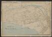
Dioecese De Rheims, et le Païs de Rethel. [Karte], in: Gerardi Mercatoris et I. Hondii Newer Atlas, oder, Grosses Weltbuch, Bd. 2, S. 53.
1 Karte aus Atlas Mercator, Gerhard und Hondius, Jodocus Jansson, Jan
Dioecese de Rheims, et le païs de Rethel
1 : 95040