Maps of Plateau Of Tibet

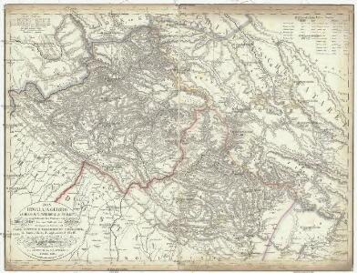
Das Himálaja Gebirg in Bissahir, Gherwal & Kemaun, von Südrande des Plateaus von Mittel-Tibet bis zum Tieflande von Hindostan
1 : 900000 Himálaj Grimm, J. L. Etzel, Franz August von C. Ritter und F.A. O'etzel
Das Himalaja Gebirg in Bissahir, Gherwal & Kemaun, von Südrande des Plateaus von Mittel-Tibet bis zum Tieflande von Hindostan
1 : 900000 Himálaj Grimm, J. L. Etzel, Franz August von C. Ritter und F.A. O'etzel
Map of High Asia

[Indien & Inner-Asien, Nördliches Blatt]
Handatlas über alle Theile der Erde und über das Weltgebäude Stieler, Adolf Justus Perthes
Inner-Asien & Indien, Nördliches Blatt
Adolf Stieler's Handatlas über alle Theile der Erde und über das Weltgebäude Stieler, Adolf Justus Perthes
India North.
1 : 5448960 Stanford, Edward
Indien & Inner-Asien, Nordliches Blatt.
1 : 7500000 Petermann, A.
India (northern sheet).
1 : 4457000 Johnston, Alexander Keith
India (northern sheet).
1 : 4457000 Johnston, Alexander Keith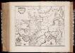
Magni Mogolis imperivm
1 : 6900000 Annotatie: Met opdracht door Joh. en Corn. Blaeu aan Johannes Huydekoper; Origineel is Blad 187 in atlas factice; Annotatie geografische gegevens: Met schaalstok: 45 Milliaria Germanica communia (=5 cm) Joan Blaeu 1597/98-1673; Cornelis Blaeu ca. 1610-1645 [Amsterdam : J. en C. Blaeu]
Magni Mogolis Imperium [Karte], in: Novus Atlas, das ist, Weltbeschreibung, Bd. 2, S. 266.
1 Karte aus Atlas Blaeu, Joan Blaeu, Willem Janszoon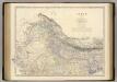
India N.
1 : 4457000 Johnston, Alexander Keith, 1804-1871
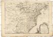
Charte von den Vereinigten Staaten von Nord-America mit Luisiana.
Spojené státy americké-oblast východní Martius, C. von Löwenberg, J.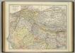
India (northern sheet).
1 : 4457000 Johnston, W. & A.K.
120-121. China, West. The World Atlas.
1 : 5000000 USSR (Union of Soviet Socialist Republics).
Carte des Etats-Unis d'Amérique, et du cours du Mississippi
Spojené státy americké-oblast východní Brion de La Tour, Louis Homann, Johann Baptist Esnauts et Rapilly
MAGNI | MOGOLIS | IMPERIVM.
[Amsterdam : Joan Blaeu]
Imperii magni Mogolis sive Indici Padschach, juxta recentißimas navigationes accurata delineatio geographica
Indie Seutter, Matthäus Seutter, Albrecht Carl sumtibus Matth. Seutteri
Nord-Indien
1 : 4000000 Indie severní War Office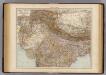
India North.
1 : 6000000 Andree, Richard; Times (London, England)
Inde N.-E. et Tibet.
1 : 5000000 Vivien St Martin, L.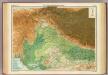
India - north-western section.
1 : 4000000 John Bartholomew & Co.
137-138. North India, Nepal, East Pakistan. The World Atlas.
1 : 5000000 USSR (Union of Soviet Socialist Republics).
N. Hindostan.
1 : 4400000 Thomson, John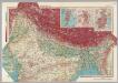
India - North. Pergamon World Atlas.
1 : 5000000 Polish Army Topography Service
Northern India Including The Presidency of Calcutta.
1 : 9000000 Tallis, J. & F.
Sindetic Hindoostan or the countries occupied by the Sinde or Indus and its branches
1 : 7000000 Cary, John, ca. 1754-1835 J. Cary
Induslander.
1 : 4000000 Kiepert, Heinrich, 1818-1899