Maps of Baden-Württemberg
Totius fluminis Rheni novissima descriptio
Rýn, řeka-oblast Wit, Frederick de Frederick de Witt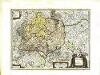
Sveviæ nova tabvla
1 Karte : Kupferdruck ; 35 x 47 cm Blaeu apud Guiljelmum Blaeuw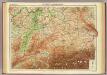
Germany - southern section.
1 : 1000000 John Bartholomew and Son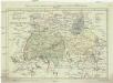
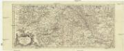
Postkarte von dem Bayrischen und Schwaebischen Kreise
Bavorsko (Německo) Müller, Franz Deilly'schen Lankarten und Kunstwerke Verschleiss Komtoir
Postkarte von dem Bayrischen und Schwaebischen Kreise
Bavorsko (Německo) Müller, Franz im von Reilly'schen Landkarten und Kunstwerke Verschleiss Komptoir
Suevia Et Bavaria XI. Nova Tabula. [Karte], in: Geographia universalis vetus et nova complectens Claudii Ptolemaei Alexandrini enarrationis libros VIII, S. 329.
1 Karte aus Atlas Münster, Sebastian [und Ptolemaeus, Claudius]
Suevia Et Bavaria XI. Nova Tabula. [Karte], in: Claud. Ptolemaeus. Geographia lat. cum mappis [...], S. 380.
1 Karte aus Atlas Münster, Sebastian [und Ptolemaeus, Claudius]
Suevia Et Bavaria XII. Nova Tabula. [Karte], in: Claud. Ptolemaeus. Geographia lat. cum mappis [...], S. 383.
1 Karte aus Atlas Münster, Sebastian [und Ptolemaeus, Claudius]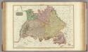
Germany south of the Mayn.
1 : 885000 Pinkerton, John, 1758-1826
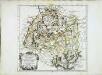
Circulus Suevicus
1 Karte : Kupferdruck ; 48 x 56 cm Lotter Tobias Konrad Lotter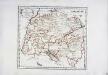
Der schwæbische Kreis
1 Karte : Kupferdruck ; 26 x 29 cm Reilly F. J. J. von Reilly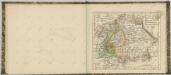

Haupt-Dreiecknetz für das Königreich Bayern
1 : 1000000 Stiglmayer Contur Obernetter Schrift [gravirt] [S.l.] : [s.n.]
Karte von Frankreich in XVI Blättern, No. 4 und [No. 8]
2 Blätter : 53 x 34 cm Königl. Preuss. Academischen Kunst und Buchhandlung
Südwestliches Deutschland
Neuer Handatlas über alle Theile der Erde Kiepert, Heinrich Verlag von Dietrich Reimer
Baden, Würtemberg, Baiern
Schul-Atlas in 36 Karten Völter, Daniel Verlag der J.M. Dannheimer'schen Buchhandlung
Totivs Sveviæ novissima tabvla
1 Karte : Kupferdruck ; 37 x 47 cm Janssonius ex officina Ioannis Ianssonii
Svevia
1 Karte : Kupferdruck ; 26 x 34 cm Merian Merian
Circulus sive Liga Sueviae Vulgo Schwabische Kraiß. [Karte], in: Theatrum orbis terrarum, S. 179.
1 Karte aus Atlas Ortelius, Abraham
Circulus sive Liga Sueviae Vulgo Schwabische Kraiß. [Karte], in: Theatrum orbis terrarum, S. 274.
1 Karte aus Atlas Ortelius, Abraham Vrients, Jan Baptista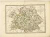

Bayern, Wurtemberg, Baden, Hohenzollern.
1 : 1500000 Meyer, Joseph, 1796-1856
Süddeutschland
Volksschul-Atlas über alle Teile der Erde Lange, Henry Druck und Verlag von Georg Westermann
SW pt. of Germany.
1 : 2300000 Bowen, Emanuel
Geognostische Karte von Württemberg, Baden und Hohenzollern
1 : 700000 Bach, Carl Philipp Heinrich Verlag der G. Ebner'schen Kunsthandlung
Bayern, Wurtemberg, Baden, Hohenzollern.
1 : 1800000 Reichard, C. G.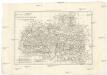
Les cercles de Souabe et de Baviere
1 : 1740000 Bavorsko (Německo) Bonne, Rigobert André
[Koenigreich Baiern, Würtemberg u. Baden]
Neuester Schul-Atlas Walch, Johann im Verlag bei Joh. Walch