Maps of Swabia

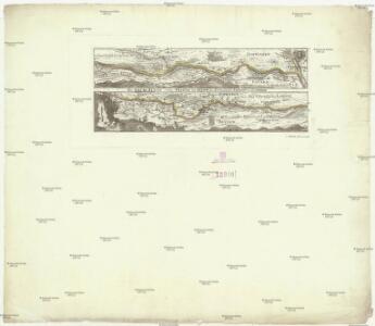
Der Lech-Fluss von Füessen im Algöw an, bis zu seinen Auslauff in die Donaw
Německo Bodenehr, Gabriel G. Bodenehr

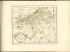
Alemannia sive Suevia Superior
Hurter, Christoph
Nova Alemanniae sive Sveviae Svperioris Tabvla
Hondius, Henricus
Nova Alemanniae Sive Sueviae Superioris Tabula. [Karte], in: Novus atlas absolutissimus, Bd. 2, S. 217.
1 Karte aus Atlas Janssonius Offizin
ALEMANNIA | SIVE | SVEVIA SVPERIOR
A. Christophoro Hurtero. [Amsterdam : Joan Blaeu]
Episcopatus Avgvstanvs compendio
1 : 630000 Mollova mapová sbírka Glasser, Johann Friedrich Mayr, Johann L. Glasser, Johann Friedrich
Bayern III.
1 : 650000 Radefeld, Carl Christian Franz, 1788-1874
Das Bisthum Augsburg mit der freyen Reichsstadt Augsburg
1 Karte : Kupferdruck ; 31 x 18 cm Reilly F. J. J. von Reilly
Totius s.r.i. circuli Suevici tabula chorographica, 4
1 Blatt : R. et J. Ottens
Alemannia sive Svevia Svperior
1 : 480000 Mollova mapová sbírka Hurter, Johann Christoph Blaeu, Joan I.
Nova Alemanniae sive Svevia Svperioris Tabvla
1 : 490000 Mollova mapová sbírka Hurter, Johann Christoph Janssonius, Johannes I
Alemaniae sive Sveviae Svperioris Chorographia nova
1 : 310000 Mollova mapová sbírka Hurter, Johann Christoph Custos, Raphael
Partie meridionale de la Souabe
1 Karte : Kupferdruck ; 46 x 65 cm L'Isle; Ottens; Ottens chez R. et I. Ottens geogr
Geographica provinciarum Sueviae descriptio, 6
6 Blätter : Johann Georg Bodenehr
Pars Sueviæ australior
1 Karte : Kupferdruck ; 46 x 61 cm L'Isle; Lotter apud Tobiam Conradum Lotter calcogr
Partie septentrionale de la Souabe
1 : 280000 par Guillaume De L'Isle A Amsterdam : chez J. Covens et C. Mortier
Partie meridionale de la Souabe
1 Karte : Kupferdruck ; 46 x 62 cm L'Isle; Renard chez l'auteur sur le quai de l'Horloge, chez L. Renard libraire prez de la bourse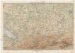
Karte der Bayrischen und Algäuer Alpen
1 : 250000 Allgäuské Alpy (Německo a Rakousko) Ravenstein, Ludwig L. Ravenstein
Totius S. R. I. Circuli Suevici Tabula Chorographica
1 : 310000 Mollova mapová sbírka Lamsvelt, Jan Ottens, Josua
Pars Sueviae Australior
1 : 250000 Mollova mapová sbírka Delisle, Guillaume Wolff, Jeremias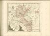

Pars Sueviae australior
1 : 310000 Württembersko (Německo) Delisle, Guillaume Lotter, Tobias Conrad T. C. Lotter
Füssen
1 : 200000 1 Karte entworfen und bearbeitet von Woerl ; in Stein gestochen unter seiner Leitung 1835 Herder, Freiburg im Breisgau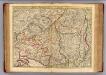
Souabe Meridionale
1 : 240000 L'Isle, Guillaume de, 1675-1726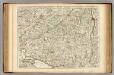
Souabe Meridionale.
1 : 240000 L'Isle, Guillaume de, 1675-1726
Suevia universa IX. tabulis delineata, 6
1 Blatt : s.n.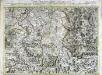
Carte topographique d'Allemagne contenant une partie de Baviére de Suabe du comté de Tirol et de l'eveché d'Augspourg
1 Karte : Kupferdruck ; 45 x 64 cm Jaeger; Facius se vend chez l'auteur