Maps of Poland

Karte der sämtlichen Preussischen Staaten
1 : 2500000 Prusko Mollo, Tranquillo bey T. Mollo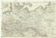
Charte vom Preussischen Staate oder Gebirgs- und Fluss- Charte des nördlichen Teutschlands
1 : 1700000 Neuchâtel (Švýcarsko) Streit, Friedrich Wilhelm Leutemann, H. J. C. Hinrichssche Buchhandlung
Prussia.
1 : 3300000 Tanner, Henry S.
Prussia.
1 : 3300000 Tanner, Henry S.
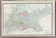
General-Karte von dem Preussischen Staate
1 : 1850000 Neuchâtel-oblast (Švýcarsko) Weiland, Karl Ferdinand im Verlage des geograph. Instituts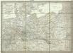
General-Karte von dem Preussischen Staate
1 : 1850000 Neuchâtel (Švýcarsko) Weiland, Karl Ferdinand im Verlage des geograph. Instituts
Prussia.
1 : 2400000 Hall, S. (Sidney)
Prussian States.
1 : 5200000 Arrowsmith, Aaron; Lewis, Samuel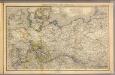
Nord- u. Mittel-Deutschland, nebst Daenemark.
1 : 1900000 Stein, Christ. Gottfr. Dan.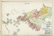
VII. 1786 - 1806
Preußen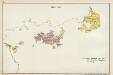
III. 1608 - 1619
Brandenburg Expansion
Kurstaat Brandenburg
Brandenburg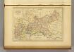
Prusse.
1 : 4100000 Malte-Brun, Conrad, 1775-1826
Prussian Dominions.
1 : 8500000 Fenner, Rest.
Germany Northern Portion.
1 : 2500000 Rand McNally and Company
Preussen, Neuchatel, Valengin.
1 : 3200000 Radefeld, Carl Christian Franz, 1788-1874
VIII. 1807 - 1815. Preußen nach dem Frieden von Tilsit
Preußen Tilsit / Friede
Carte Generale du Royaume de Prusse.
1 : 3000000 Vivien de St Martin, L.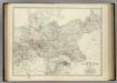
Empire of Germany (northern portion).
1 : 2032000 Johnston, Alexander Keith
[Historisch-geographischer Atlas zu den allgemeinen Geschichtswerken von C. v. Rotteck, Pölitz u. Becker] : Preussen unter der Regierung Friedrich's des Grossen
von Julius Loewenberg Lithographie von B. Herder in Freiburg im Breisgau [Freiburg im Breisgau] : [Herder]
Prussia.
1 : 4118400 Tallis, J. & F.
Prussia.
1 : 3200000 Mitchell, Samuel Augustus
Nord-Deutschland
Geographischer Atlas über alle Theile der Erde Ziegler, Jakob Melchior Verlag von Joh. Wurster um Comp.
Monarchie Prussienne.
1 : 2400000 Brue, Adrien Hubert, 1786-1832
Prussian States.
1 : 3900000 Greenleaf, Jeremiah
Prussian States.
1 : 3900000 Greenleaf, Jeremiah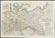
[Neuer Atlas der ganzen Erde nach den neuesten Bestimmungen ... : XVI.] Charte von Preussischen Staate, Gebirgs- und Fluss-Charte des nördlichen Teutschlands
Neu entworfen und gezeichnet von F.W. Streit gest. v. H. Leutemann Leipzig : J.C. Hinrichssche Buchhandlung


