Maps of Potsdam-Mittelmark

Richtiger geograph. Entwurff des zu dem Saechs. Chur. Creisse gehörigen Ammtes Beltzig
1 : 125000 Braniborsko (Německo) Schenk, Pieter bey Petrus Schenk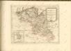

89. Potsdam, uit: Topographische Uebersichtskarte des Deutschen Reiches / herausgegeben v. d. Kartogr. Abt. d. Königl. Preuß. Landesaufnahme
1 : 200000 titelvariant: Topogr. Übersichtskarte des Deutschen Reiches; Annotatie: Titel boven bladen ook: Topogr. Übersichtskarte des Deutschen Reiches; Annotatie geografische gegevens: Op elk blad twee maatstokken: 10 Kilometer = 5,5 cm; 1 geogr. Meile = 3,6 cm; Legenda onder op elk blad Königlich Preußische Landesaufnahme. Kartographische Abtheilung [S.l : Königlich Preußische Landesaufnahme, Kartographische Abtheilung]
Mappa Geographica exhibens Dvcatvm Saxoniae Specialiter Sumtum, et qui Praerogativa Electorali gaudet :
1 : 110000 Mollova mapová sbírka Homann, Johann Baptist Homann, Johann Baptista - dědici
316. Belzig.
1 : 100000 Reichsamt fur Landesaufnahme
Composite: 316. Belzig.
1 : 100000 Reichsamt fur Landesaufnahme
Composite: 292. Brandenburg a. d. Havel
1 : 100000 Reichsamt fur Landesaufnahme
292. Brandenburg a. d. Havel
1 : 100000 Reichsamt fur Landesaufnahme
Blatt IX Werder, uit: Karte von Berlin und Umgebung in 12 Blättern
1 : 50000 Annotatie: Toelichtingen opgeborgen bij kaart; Annotatie geografische gegevens: Met schaalstokken: Meter, Schritt, geographische Meile Paul Schneider Berlin : Reichsamt für Landesaufnahme
Treffen bei Hagelsberg den 27ten August 1813
1 : 25000 Braniborsko (Německo) Brose, Heinrich
Meßtischblatt 4043 : Blönsdorf, 1939
1 : 250000 Blönsdorf. - Hrsg. 1904, bericht. 1927/28, einz. Nachtr. 1939. - 1:25000. - [Berlin]: Reichsamt für Landesaufnahme, 1939. - 1 Kt.
Meßtischblatt 2245 : Blönsdorf, 1933
1 : 250000 Blönsdorf. - Hrsg. 1904, bericht. 1927/28, einz. Nachtr. 1933. - 1:25000. - [Berlin]: Reichsamt für Landesaufnahme, 1933. - 1 Kt.
Meßtischblatt 2245 : Blönsdorf, 1925
1 : 250000 Blönsdorf. - Aufn. 1902, bericht. 1925. - 1:25000. - [Berlin]: Reichsamt für Landesaufnahme, 1925. - 1 Kt.
Meßtischblatt 200 : Wölmsdorf, 1874
1 : 250000 Wölmsdorf. - Aufn. 1851. - 1:25000. - [Berlin]: Reichsamt für Landesaufnahme, 1874. - 1 Kt.
Meßtischblatt 4042 : Zahna, 1937
1 : 250000 Zahna. - Hrsg. 1904, einz. Nachtr. 1931. - 1:25000. - [Berlin]: Reichsamt für Landesaufnahme, 1937. - 1 Kt.
Meßtischblatt 22444 : Zahna, 1921
1 : 250000 Zahna. - Aufn. 1902, kleine Nachtr. 1921. - 1:25000. - [Berlin]: Reichsamt für Landesaufnahme, 1921. - 1 Kt.
Meßtischblatt 2244 : Zahna, 1904
1 : 250000 Zahna. - Aufn. 1902. - 1:25000. - [Berlin]: Reichsamt für Landesaufnahme, 1904. - 1 Kt.
Meßtischblatt 199 : Zahna, 1874
1 : 250000 Zahna. - Aufn. 1851. - 1:25000. - [Berlin]: Reichsamt für Landesaufnahme, 1874. - 1 Kt.
Meßtischblatt 4041 : Straach, 1938
1 : 250000 Straach. - Hrsg. 1904, einz. Nachtr. 1938. - 1:25000. - [Berlin]: Reichsamt für Landesaufnahme, 1938. - 1 Kt.
Meßtischblatt 2243 : Straach, 1925
1 : 250000 Straach. - Aufn. 1902, Nachtr. 1925. - 1:25000. - [Berlin]: Reichsamt für Landesaufnahme, 1925. - 1 Kt.
Meßtischblatt 2243 : Straach, 1904
1 : 250000 Straach. - Aufn. 1902. - 1:25000. - [Berlin]: Reichsamt für Landesaufnahme, 1904. - 1 Kt.
Meßtischblatt 2243 : Straach, 1874
1 : 250000 Straach. - Aufn. 1851. - 1:25000. - [Berlin]: Reichsamt für Landesaufnahme, 1874. - 1 Kt.
Meßtischblatt 2242, neue Nr. 4040 : Hundeluft, 1938
1 : 250000 Hundeluft. - Hrsg. 1904, bericht. 1927, einz. Nachtr. 1938. - 1:25000. - [Berlin]: Reichsamt für Landesaufnahme, 1938. - 1 Kt.
Meßtischblatt 2242 : Zieko, 1874
1 : 250000 Zieko. - Aufn. 1852. - 1:25000. - [Berlin]: Reichsamt für Landesaufnahme, 1874. - 1 Kt.
Meßtischblatt 4039 : Mühlstedt, 1936
1 : 250000 Mühlstedt. - Hrsg. 1904, bericht. 1927. - 1:25000. - [Berlin]: Reichsamt für Landesaufnahme, 1936. - 1 Kt.
Meßtischblatt 2241 : Mühlstedt, 1872
1 : 250000 Mühlstedt. - Aufn. 1852. - 1:25000. - [Berlin]: Reichsamt für Landesaufnahme, 1872. - 1 Kt.
Meßtischblatt 2175 : Treuenbrietzen, 1925
1 : 250000 Treuenbrietzen. - Aufn. 1900, bericht. 1925. - 1:25000. - [Berlin]: Reichsamt für Landesaufnahme, 1925. - 1 Kt.
Meßtischblatt 2175 : Treuenbrietzen, 1902
1 : 250000 Treuenbrietzen. - Aufn. 1900. - 1:25000. - [Berlin]: Reichsamt für Landesaufnahme, 1902. - 1 Kt.
Meßtischblatt 3942 : Niemegk, 1942
1 : 250000 Niemegk. - Aufn. 1900, hrsg. 1902, letzte Nachtr. 1941. - 1:25000. - [Berlin]: Reichsamt für Landesaufnahme, 1942. - 1 Kt.


