Maps of Czech Republic

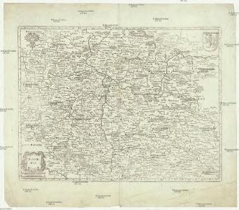
Bohemia
1 : 1200000 Čechy (Česko) Merian, Matthaeus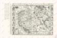
Bez titulu: Soubor reprintů starých map

Historická mapa Čech

Le Royaume de Boheme :
1 : 715000 Mollova mapová sbírka Nolin, Jean-Baptiste Nolin, Jean Baptiste II.
Regni Bohemiae Tabula.
1 : 1150000 Mollova mapová sbírka Pfeffel, Johann Andreas Brugge, Johannes van der
Das Königreich Böhmen mit seinen abgetheilten Creissen
1 : 1900000 Mollova mapová sbírka Weigel, Christoph Weigel, Christoph I.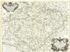
Il Regno di Bohemia descritto sù l'Esemplare delle Carte Migliori
1 : 715000 Mollova mapová sbírka Cantelli, Giacomo De Rossi, Giovanni Giacomo
Historická mapa Čech

Králowstwí České
1 : 400000 Česko Loth, Johann Marco Berra
Topographisch-statistische Post und Strassenkarte des Königreiches Boehmen
1 : 370000 Česko Loth, Johann Anděl, Bedřich Johann Loth
Topographisch-statistische Post und Strassenkarte des Königreiches Boehmen
1 : 370000 Česko Loth, Johann Johann Loth
Topographisch-statistische Post und Strassenkarte des Königreiches Boehmen
1 : 370000 Praha (Česko) Loth, Johann Johann Loth
Bez titulu: Statistické mapky Čech

Bohemiae Regnum
1 : 1600000 Mollova mapová sbírka Seutter, Matthäus Lotter, Tobias Conrad Seutter, Matthäus
Nova Totius Regni Bohemiae Tabula
1 : 405000 Mollova mapová sbírka Vogt, Mauritius Blanck, Johann Leonhard Zieger, Johann
Regni Bohemiae Tabula
1 : 1150000 Mollova mapová sbírka Reiffenstuell, Ignatius Schlegel, Johann Georg
Karten zur Statistik des Königreiches Böhmen...

Haec tabvla Regni Boemiae
1 : 512000 Česko Vusín, Kašpar Zachariáš Casparus Wussin
Übersichtskarte der Kohlenformationen und Eisenbahnen in Böhmen
Duchcov-oblast (Česko)
Karte der Volks-Schul-Bezirke, der Mittelschulen, Lehrer-Bildungsanstalten und gewerblichen Fachschulen des Königreiches Böhmen
1 : 600000 Česko Hickmann, Anton L. A.L. Hickmann
Karte der Bezirks-Hauptmannschaften (politischen Bezirke) und der Eisenbahn-Linien im Königreiche Böhmen
1 : 600000 Česko Hickmann, Anton L. A.L. Hickmann
Karte der Volks-Schul-Bezirke, der Mittelschulen, Lehrer-Bildungsanstalten und gewerblichen Fachschulen des Königreiches Böhmen
1 : 600000 Česko Hickmann, Anton L. Steyrer, Fr. C. A.L. Hickmann
Sprachen-Karte des Königreiches Böhmen nebst Angabe des Landtags-Wahlbezirke
1 : 600000 Česko Hickmann, Anton L. A.L. Hickmann
Geologisch-Montanistische Karte des Königreiches Böhmen
1 : 600000 Česko Hickmann, Anton L. A.L. Hickmann
Karte der Bewölkerungsdichte (relative Bevölkerung) des Königreiches Böhmen
1 : 600000 Česko Hickmann, Anton L. A.L. Hickmann
Forst-Karte des Königreiches Böhmen nebst Angabe der Zuckerfabriken, Bierbrauereien und Mahlmühlen
1 : 600000 Česko Hickmann, Anton L. A.L. Hickmann
Regni Bohemiae tabula
Česko Pfeffel, Johann Andreas Engelbrecht, Christian Pfeffel et Engelbrecht
Mappa Geographica Totius Regni Bohemiae in XII. Provincias divisae adjunctis Comitatu Glacensi Regione Egrana et Limitibus finitimarum Provinciarum
1 : 650000 Mollova mapová sbírka Gütl, Philipp
Mappa Geographica Totius Regni Bohemiae in XII. Provincias divisae adjunctis Comitatu Glacensi Regione Egrana et Limitibus finitimarum Provinciarum.
1 : 650000 Mollova mapová sbírka Gütl, Philipp Gütl, Philipp
Mappa Geographica Totius Regni Bohemiae in XII. Circulos divisae
1 : 685000 Mollova mapová sbírka Lotter, Tobias Conrad Lotter, Tobias Conrad