Maps of Spain

SPANIEN und PORTUGAL 1847
1 : 4440000 Madrid (Španělsko) Bornmüller, H. Bibliographisches Institut
Carte des routes de postes et itinéraires d'Espagne et de Portugal
1 : 2440000 Portugalsko Lapie, Pierre Picquet, Ch. Artaria
Carte des routes de postes et itinéraires d'Espagne et de Portugal
1 : 2440000 Portugalsko Picquet, Ch. Lapie, Pierre Artaria
Mapa de Espana
1 : 2000000 Kanárské ostrovy Instituto geográfico
Espagne et Portugal
1 Karte : Kupferdruck ; 31 x 42 cm Mentelle; Tardieu Mentelle
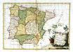
Spanien und Portugal
1 : 2350000 Cádiz (Španělsko) Weiland, Karl Ferdinand im Verlage des Geographischen Instituts
Spanien und Portugal
1 : 2350000 Cádiz (Španělsko) Weiland, Karl Ferdinand im Verlage des Geographischen Instituts
Spanien und Portugal
1 : 2280000 Portugalsko Weiland, Karl Ferdinand im Verlage des Geograph. Instituts
La Spagna e Portogallo
Portugalsko Zatta, Antonio A. Zatta
Espagne
1 Karte : Kupferdruck ; 31 x 41 cm Mentelle; Tardieu Mentelle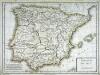
Hispanie Betique et Lusitanie
1 Karte : Kupferdruck ; 31 x 41 cm Mentelle; Tardieu Mentelle
Spain & Portugal.
1 : 4300000 Finley, Anthony
Spain and Portugal.
1 : 3000000 Tanner, Henry S.
Karte von dem Iberischen Halb-Insellande, oder den Königreichen Spanien und Portugal
1 : 1500000 entworfen und in den Jahren 1826-1829 bearb. von Heinrich Berghaus gestochen von Heinrich Brose ; Schrift von Wilhelm Brose München : Cotta
L'Espagne subdivisée en tous ses royau.mes, princip.tés, seign.ries, & exactem. reveüe, corigée, et augmentée dessus ce qui en a esté veu jusques a present
1 : 2780000 Španělsko Sanson, Nicolas Cordier, Louis Pierre Mariette
Espagne et Portugal.
Andriveau-Goujon, J.
Spanien und Portugal
Portugalsko
Spanien und Portugal
Volksschul-Atlas über alle Teile der Erde Lange, Henry Druck und Verlag von Georg Westermann
Composite: Spanien, Portugal.
1 : 1800000 Theinert, A.
Soubor němých map pro gymnasia a odborné školy
Li regni di Spagna e Portogallo
1 Karte : Kupferdruck ; 28 x 40 cm Zatta presso Antonio Zatta
Typvs Hispaniæ
1 Karte : Kupferdruck ; 35 x 48 cm Janssonius; Gerritsz ex officina ære et sumptibus Ioannis Ianssonii
Regnorvm Hispaniæ nova descriptio
1 Karte : Kupferdruck ; 36 x 48 cm Blaeu apud Guiljelmum Blaeuw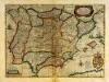
Typvs Hispaniæ
1 Karte : Kupferdruck ; 35 x 48 cm Mercator; Hondius; Gerritsz ex officina ære et sumptibus Henrici Hondij F
Carte routière des royaumes d'Espagne et de Portugal : réduite d'après la Carte itinéraire publiée par le Dépôt de la Guerre
1 : 1850000 par L. H. Berthe A Paris : Berthe
A new map of Spain and Portugal : exhibiting the chains of mountains with their passes, the principal & cross roads, with other details requisite for the intelligence of military operations / comp. by Jasper Nantiat
1 : 850000 Annotatie: Met afstandentabel Nantiat, Jasper London : W. Faden
Spain & Portugal.
1 : 1900800 Stanford, Edward
Karte von Spanien
1 : 2000000 nach der neuen Karte von Lopez in 4 Blat, und seinen ältern Zeichnungen der einzelnen Provinzen, an der Südküste nach Toffino, und mit einiger Beyhülfe von Mentelle's Karten entworfen 1798 von Conrad Mannert Nürnberg : Schneider u. Weigels
Regnorum Hispaniae et Portvgalliae tabula generalis ad statum hodiernum in suas provincias divisa
1 : 2370000 Portugalsko López, Tomás Güssefeld, Franz L. edentibus Hommanianis Haeredibus
Regnorum Hispaniae et Portvgalliae tabula generalis ad statum hodiernum in suas provincias divisa
1 : 2370000 Portugalsko López, Tomás Güssefeld, Franz L. edentibus Hommanianis Haeredibus


