Maps of Alföld

Magyarország népességénék müveltségi foka 1890
1 : 5000000 Maďarsko Homolka, Josef Posner Károly Lajos és fia
Magyarország közigazgatási törvénykezési és közlekedési térképe
1 : 3450000 Maďarsko Homolka, Josef Posner Károly Lajos és fia
Magyarország földtani térképe
1 : 3450000 Maďarsko Homolka, Josef Posner Károly Lajos és fia
Magyarország hömérsékleti és esözési térképei
Maďarsko Homolka, Josef Posner Károly Lajos és fia
Magyarország megyei térképe
1 : 5430000 Evropa jižní Homolka, Josef M. Kir. Államnyomdából
Magyarország a török hódoltság idejében
1 : 4350000 Maďarsko Homolka, Josef Ferencz, Salomon Eggenberger féle könyvkeresk. (Hofmann és Molnár)
Magyarország megyei beosztása 1848
1 : 4000000 Maďarsko Homolka, Josef Elek, Fényes Eggenberger féle könyvkeresk. (Hofmann és Molnár)
Magyarország egyházi beosztása 1891
1 : 4450000 Maďarsko Homolka, Josef Eggenberger féle könyvkeresk. (Hofmann és Molnár)
Magyarország hadügyi beosztása 1891
1 : 4450000 Maďarsko Homolka, Josef Eggenberger féle könyvkeresk. (Hofmann és Molnár)
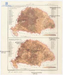
Magyarország néprajzi térképe
1 : 4450000 Maďarsko Homolka, Josef Eggenberger féle könyvkeresk. (Hofmann és Molnár)
Magyarország hegyei és vizei
1 : 5320000 Budapešť (Maďarsko : oblast) Homolka, Josef M. Kir. Államnyomdából
Hungaria Regnum

Hungaria in Partes II et Comitatus LII divisa
1 : 4300000 Mollova mapová sbírka Tomka Szászky, János
Neüwe und gründtliche beschreibunge des ganczen Künigreichs Unngern mit den an[...]
Maďarsko
[80][80] Regnum Hungaria ..., uit: Atlas sive Descriptio terrarum orbis
Annotatie: Gedigitaliseerde versie. Amsterdam. Heiloo : Picturae (vervaardiger), 2015. tiff-bestand. Gedigitaliseerd: 07-01-2015; Origineel: Universiteitsbibliotheek Vrije Universiteit (XL.05127.-) ; Netherlands; Titelpagina ontbreekt Wit, Frederik de Amsterdam : Frederick de Wit
Magyar-ország
1 : 1400000 Chorvatsko Fried, Franz List, Joseph bei Artaria &. Comp.
Magyarország és a' Hozzá kapcsolt tartományok Földabrosza
1 : 970000 Chorvatsko Raffelsperger, Franz Raffelsperger F.
Hungariae Descriptio [Karte], in: Theatrum orbis terrarum, S. 99.
1 Karte aus Atlas Ortelius, Abraham
Royaume de Hongrie et pays adjacents
1 : 3420000 Maďarsko Bonne, Rigobert André
Hungaria Regnum. [Karte], in: Gerardi Mercatoris et I. Hondii Newer Atlas, oder, Grosses Weltbuch, Bd. 1, S. 346.
1 Karte aus Atlas Mercator, Gerhard und Hondius, Jodocus Jansson, Jan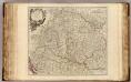
Hongrie, Transilvanie, Sclavonie, Croatie, Valaquie, Bosnie, Bulgarie.
1 : 1450000 Robert de Vaugondy, Gilles, 1688-1766
Regnum Hungaria in Omnes suos Comitatus

Carte particuliere de la Hongrie de la Transilvanie de la Croatie et de la Sclavonie
1 : 1400000 Chorvatsko Delisle, Guillaume J. Covens et C. Mortier
Die kaiserlich oesterreichischen ungarischen Erbstaaten
1 : 1522000 Dalmácie (Chorvatsko) Weiland, Karl Ferdinand im Verlage des Geographischen Instituts
Die kaiserlich oesterreichischen ungarischen Erbstaaten
1 : 1522000 Dalmácie (Chorvatsko) Weiland, Karl Ferdinand im Verlage des Geographischen Instituts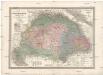
Die kaiserlich oesterreichischen ungarischen Erbstaaten
1 : 1522000 Dalmácie (Chorvatsko) Weiland, Karl Ferdinand im Verlage des Geographischen Instituts
Hungariae Regnum. [Karte], in: Novus atlas absolutissimus, Bd. 2, S. 285.
1 Karte aus Atlas Janssonius Offizin
Hungariae Descriptio [Karte], in: Theatrum orbis terrarum, S. 265.
1 Karte aus Atlas Ortelius, Abraham
Mappa novissima regnorum Hungariae, Croatiae, Sclavoniae, nec non magni principatus Transylvaniae
1 : 707000 Chorvatsko Lipský, Ján Artaria