Maps of Karlovy Vary
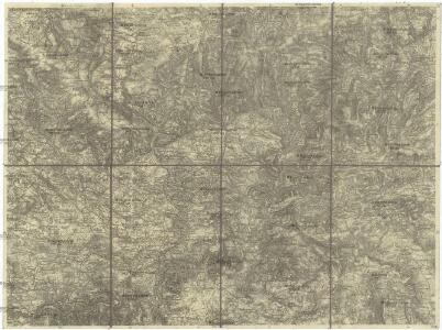
Ostrov u Karlových Varů a okolí
1 : 75000 Karlovy Vary (Česko : oblast) Vojenský zeměpisný ústav
[Vilímkovy místopisné mapy zemí Koruny české]
1 : 100000 Jáchymov (Karlovy Vary, Česko : oblast) Srp, Jan Jos. R. Vilímek
Podrobná mapa Království českého
1 : 100000 Jáchymov (Karlovy Vary, Česko : oblast) Srp, Jan Jos. R. Vilímek
Lichtenstädter Vikariat
Hroznětín (Karlovy Vary, Česko)
Karlsbad
1 : 220000 Karlovy Vary-oblast (Česko) Streit, Friedrich Wilhelm Müller, Leopold
Karlsbader Bezirkskarte
1 : 75000 Karlovy Vary-oblast (Česko) Kutschera, G. G. Kutschera
[Kartenblatt]
1 : 25000 Jáchymov (Karlovy Vary, Česko : oblast) Reichsamt für Landesaufnahme
III. vojenské mapování 3850/3
1 : 25000
Gradkartenblatt
1 : 25000 Ostrov-oblast (Karlovy Vary, Česko) Bellschan, Anton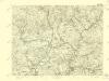
III. vojenské mapování 3850/3
1 : 25000

III. vojenské mapování 3849/4
1 : 25000
[Kartenblatt]
1 : 25000 Abertamy (Česko) Reichsamt für Landesaufnahme
III. vojenské mapování 3849/4
1 : 25000
Karte von Karlsbad und Umgebung
1 : 25000 Karlovy Vary-oblast (Česko) Freytag, Gustav G. Freytag & Berndt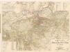
Karlsbader Promenaden-Plan mit Umgebung
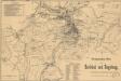
Promenaden-Plan von Karlsbad und Umgebung
[Kutná Hora a okolí]
Kutná Hora-oblast (Česko) Platzer, Thaddaeus Schäfler, J.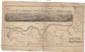
Promenaden-Plan von Carlsbad zur König Otto's Quelle
Karlovy Vary (Česko) Schäfler, J. Gebr. Franieck
Geologisch-Bergmännische Detail-Karte von Joachimsthal und Umgebung
1 : 25000 Jáchymov-oblast (Karlovy Vary, Česko) Babánek, František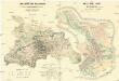
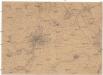
Umgebung von Karlsbad
1 : 18000 Karlovy Vary (Česko) Souvent, Alois Rauh, Johann
Karlsbader Promenaden-Plan mit Umgebung
Karlovy Vary (Česko) Kudrnka, Josef Hennig, C. Hermann Jakob
Joachimsthal - c2735-1-018 - Kaiserpflichtexemplar der Landkarten des stabilen Katasters
1 : 2880
Joachimsthal - c2735-1-020 - Kaiserpflichtexemplar der Landkarten des stabilen Katasters
1 : 2880
Joachimsthal - c2735-1-013 - Kaiserpflichtexemplar der Landkarten des stabilen Katasters
1 : 2880
Joachimsthal - c2735-1-001 - Kaiserpflichtexemplar der Landkarten des stabilen Katasters
1 : 2880
Joachimsthal - c2735-1-017 - Kaiserpflichtexemplar der Landkarten des stabilen Katasters
1 : 2880
Joachimsthal - c2735-1-010 - Kaiserpflichtexemplar der Landkarten des stabilen Katasters
1 : 2880
Joachimsthal - c2735-1-016 - Kaiserpflichtexemplar der Landkarten des stabilen Katasters
1 : 2880
Joachimsthal - c2735-1-006 - Kaiserpflichtexemplar der Landkarten des stabilen Katasters
1 : 2880
Joachimsthal - c2735-1-002 - Kaiserpflichtexemplar der Landkarten des stabilen Katasters
1 : 2880
Joachimsthal - c2735-1-012 - Kaiserpflichtexemplar der Landkarten des stabilen Katasters
1 : 2880
Joachimsthal - c2735-1-011 - Kaiserpflichtexemplar der Landkarten des stabilen Katasters
1 : 2880
Joachimsthal - c2735-1-009 - Kaiserpflichtexemplar der Landkarten des stabilen Katasters
1 : 2880
Joachimsthal - c2735-1-005 - Kaiserpflichtexemplar der Landkarten des stabilen Katasters
1 : 2880
Joachimsthal - c2735-1-014 - Kaiserpflichtexemplar der Landkarten des stabilen Katasters
1 : 2880
Joachimsthal - c2735-1-015 - Kaiserpflichtexemplar der Landkarten des stabilen Katasters
1 : 2880
Joachimsthal - c2735-1-003 - Kaiserpflichtexemplar der Landkarten des stabilen Katasters
1 : 2880
Joachimsthal - c2735-1-007 - Kaiserpflichtexemplar der Landkarten des stabilen Katasters
1 : 2880
Joachimsthal - c2735-1-004 - Kaiserpflichtexemplar der Landkarten des stabilen Katasters
1 : 2880
Joachimsthal - c2735-1-019 - Kaiserpflichtexemplar der Landkarten des stabilen Katasters
1 : 2880