Maps of Lampung
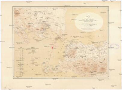
Kaart van Het Gedeelte Java en Sumatra
1 : 500000 Jáva (Indonésie) Eckstein, G. A. Gebroeders Van Cleef
To Captain Krusenstern, of the Imperial Russian Navy, as a tribute for his laudable exertions to benefit navigation and maritime science
1 : 443750 this chart of the Strait of Sunda is inscribed by [...] James Horsburgh [London] : by James Horsburgh, hydrographer to the Hon.ble East India Co.
Kaart van Straat Soenda : overgenomen van de Zeekaart van 1870 / get[ekend door] J.G. de Groot
Bruxelles : Institut National de Géographie
Overzichtskaart van de Residentie Lampoengsche Districten / Topografische Dienst
Topografische Dienst Weltevreden Weltevreden (Batavia) : Reproductiebedrijf Topografische Dienst
Marga-indeeling Residentie Lampongsche Districten
[S.l. : s.n.]
Afstandswijzerkaart van de Lampongsche Districten : vastgesteld bij artikel 1 van het besluit van den Gouverneur-Generaal van Nederlandsch-Indie van 6 januari 1915 (Staatsblad no.11)
[S.l. : s.n.]
Residentie Lampongse Districten / bewerkt door het Encyclopaedisch Bureau
Encyclopaedisch Bureau Batavia Welt[evreden] (Batavia) : Top[ografische] Inr[ichting]
[Teloekbetoeng]
Topografische Dienst Batavia Batavia : Reproductiebedrijf Topografische Dienst
Teloekbetoeng / Survey of India
Survey of India [S.l.] : Survey of India
Kaart van de Residentie Bantam : op de schaal van 1:20.000 (gedeeltelijk ook op schaal van 1:40.000) opgenomen ingevolge Gouvernements Besluit d.d. 6 juli 1866, No. 8, in de jaren 1878 t/m 1885 / Topographisch Bureau van de Generale Staf, Batavia
Topographisch Bureau van de Generale Staf Batavia [Batavia : Topographisch Bureau van de Generale Staf]
Overzichtskaart van de residentie Bantam / Topogr[afische] Inrichting
Topografische Inrichting Batavia Batavia : Topogr[afische] Inrichting
Overzichtskaart van den ontworpen spoorweg van Batavia naar Anjer : met zijtakken van Doerie naar Tangerang en van Tanahabang naar Weltevreden
Bataviaasch Nieuwsblad Batavia ; Weltevreden : G. Kolff & Co.
Menggala / published by War Office = uitgegeven door War Office ; revised and photolithographed by War Office
War Office Washington D.C. [Washington D.C.] : War Office
Teloekbetoeng / published by War Office = uitgegeven door War Office ; revised and photolithographed by War Office
War Office Washington D.C. [Washington D.C.] : War Office
Kota-Agoeng / published by War Office = uitgegeven door War Office ; revised and photolithographed by War Office
War Office Washington D.C. [Washington D.C.] : War Office
Batavia / prepared under the direction of the Chief of Engineers U.S. Army by the Army Map Service
Army Map Service Washington D.C. Washington D.C. : Army Map Service
Batoeradja / published by War Office = uitgegeven door War Office ; revised and photolithographed by War Office
War Office Washington D.C. [Washington D.C.] : War Office
Laboehan / prepared under the direction of the Chief of Engineers U.S. Army by the Army Map Service
Army Map Service Washington D.C. Washington D.C. : Army Map Service
Kaart van de afdeeling Boemi Agoeng (Lampongsche Districten) / [overgenomen van een algemeene kaart der Lampongs van] B. Vitzthum von Eckstaedt del. ; J. Postma lith
Aardrijkskundig Genootschap Amsterdam Amsterdam : C.F. Stemler
[Sundastrasse]
1 : 200000 Joh. C. Stemler Cz.
[Jakarta]
1 : 200000 Joh. C. Stemler Cz.
Atlas behoorende bij het eindverslag over het Geologisch-Mijnbouwkundig Onderzoek in de Residentie Benkoelen
[S.l. : s.n.]
[Ranau-Meer]
Topografische Dienst Batavia Batavia : Reproductiebedrijf Topografische Dienst
Overzichtskaart van de residentie Batavia / [door het] Topographisch Bureau
Topographisch Bureau Batavia Batavia : Topographisch Bureau
Batavia

Kaart van de Residentie Batavia

Menggala / [bew. door J. van Tuijn]
Dienst van den Mijnbouw in Nederlandsch-Indië Batavia [Batavia] : Dienst van den Mijnbouw in Nederlandsch-Indië
Kota·agoeng / [bew. door J. Zwierzycki]
Dienst van den Mijnbouw in Nederlandsch-Indië Batavia [Batavia] : Dienst van den Mijnbouw in Nederlandsch-Indië
Bengkoenat / [bew. door J. Westerveld]
Dienst van den Mijnbouw in Nederlandsch-Indië Batavia [Batavia] : Dienst van den Mijnbouw in Nederlandsch-Indië