Maps of Czech Republic

Železniční mapa Království českého
České království
Mapa poněmčování zemí koruny České

Poutní místa
Česko
Übersichtskarte des Protektorats Böhmen und Mähren

Übersichtskarte des Protektorats Böhmen und Mähren

Vilímkovy místopisné mapy zemí Koruny České

Čechy, Morava a Slezsko
Česko Wagner, Jan Eduard sklad Jaroslava Pospíšila
Čechy - Morava Příruční a cestovní mapa

Železniční mapa Čech, Moravy a Slezska
Česko tiskem a nákladem Karla Bellmanna
Železniční a národopisná mapa Zemí koruny České a Rakouska-Uherska s vyznačením hranic diecésáních [sic] a obvodů obchodních komor
Česko Schnizer, E. von Jungmann, Carl F.B. Batovec
Mapa činnosti Ústřední matice škol v Praze v letech 1880-1930
1 : 770000 Praha (Česko : oblast) Hocke, Jan V. Neubert a synové
Spätlatènezeit
Böhmen, Mähren, Archäologie
Karte vom Königreiche Boehmen der Markgrafschaft Maehren und des Herzogthumes Schlesien
1 : 991000 Česko Fried, Franz Artaria und Compag.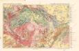
Přehledná geologická mapa zemí sudetských

Protektorat Böhmen-Mähren
1 : 500000 Praha (Česko) Edvard Fastr
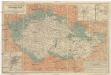
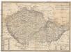
Mapa zemí koruny České

Äneolithikum
Böhmen, Mähren, Archäologie
Bohmen, Mahren.
1 : 1500000 Andree, Richard
Carte économique de la Boheme et de la Moravie
Morava (Česko) V. Neubert & Sons Press
Isotermy v zemi České a Moravskoslezské
Železniční a národopisná mapka Zemí koruny české 1899
Brno-oblast (Česko) F.B. Batovec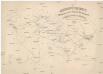
Übersichtskarte der evangelischen Kirche Augsb. und Helv. Confession
1 : 864000 Morava (Česko) Strehl, Anton k. k. evangel. Oberkirchenrathe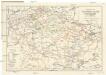
Železniční síť Čech, Moravy, Slezska a zemí sousedních
1 : 1000000 Česko Matějček, Josef Jos. Matějček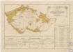
Přehled sokolských jednot česko-moravských počátkem července 1869
Karte vom Königreich Boehmen der Markgraschaft Maehren und des Herzogthumes Schlesien
1 : 980000 Česko Fried, Franz Artaria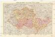
Protektorat Böhmen und Mähren
1 : 750000 Protektorát Čechy a Morava Edvard Fastr
Protektorat Böhmen und Mähren
1 : 750000 Protektorát Čechy a Morava Edvard Fastr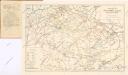
Železniční síť Čech, Moravy, Slezska a zemí sousedních

Übersichtskarte der Werwaltungsbezirke im Protektorat Böhmen und Mähren


