Maps of Kotor

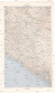
Dubrovnik - Kotor
1 : 200000 Dubrovník (Chorvatsko : oblast) Kartografska radionica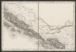
[Umgebung von Dubrovnik]
Kroatien Dalmatien Ragusa (Dalmatien) Umland
Skize jenes Theiles des Kreises Cattaro in welchem die nördliche Gränze zu ersehen ist, wie sie gegenwärtig besteht, - und wie sie diplomatisch in der Richtung der Nr.24_33_34_35 und 36 bestehen sollte
1 : 84222 Boka Kotorska, Kotor (Region), Grenze Jabornigg von Altenfels, Rudolf
Bileca.
from Spezialkarte der osterreichisch-ungarischen Monarchie.
Ragusa.
from Spezialkarte der osterreichisch-ungarischen Monarchie.
Gacko und Orahovica.
from Spezialkarte der osterreichisch-ungarischen Monarchie.
Trebinje und Risano.
from Spezialkarte der osterreichisch-ungarischen Monarchie.
Übersichtsblatt zum Kriegsspielplan der Umgebung von Cattaro
1 : 12500 Kotor (Černá Hora) K. u. k. militär-geographisches Institut
Ljubinje und Slano.; Spezialkarte der osterreichisch-ungarischen Monarchie.
from Spezialkarte der osterreichisch-ungarischen Monarchie. Austro-Hungarian Monarchy. Militärgeographisches Institut.,
Zalom und Stolac.; Spezialkarte der osterreichisch-ungarischen Monarchie.
from Spezialkarte der osterreichisch-ungarischen Monarchie. Austro-Hungarian Monarchy. Militärgeographisches Institut.,
Buchta Boko-di-Kataro
Montenegro Kotor Seeschlacht
Ulog und Nevesinje.; Spezialkarte der osterreichisch-ungarischen Monarchie.
from Spezialkarte der osterreichisch-ungarischen Monarchie. Austro-Hungarian Monarchy. Militärgeographisches Institut.,
Busen von Cattaro
1 : 500000 Boka Kotorska
Umgebung von Cattaro

Umgebung von Cattaro

Jelec und Tjentista.
from Spezialkarte der osterreichisch-ungarischen Monarchie.
Cattaro.
from Spezialkarte der osterreichisch-ungarischen Monarchie.
Carte des BOUCHES de CATTARO et du MONTENEGRO
1 : 49000 boka Kotorská (Černá Hora) Traux, Maximilian de Stein, Carl Artaria et Comp.
Carte du théâtre de l'insurrection des Bouches de Cattaro
1 : 143400 boka Kotorská (Černá Hora)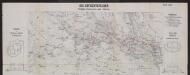
Die Gefechtsfelder Trebinje, Grančarevo und Klobuk
Bosnien-Herzegowina Gefechtsfeld
[Eisenbahnnetz Ragusa-Trebinje]
Kroatien Dalmatien
[Umgebung von Molunat ; Politische Einteilung]
Kroatien Dalmatien Dalmatien Umland
Bocche di Cattaro
1 : 150000 Montenegro Boka Kotorska
Plan goroda i zaliva Raguza
Kroatien Dubrovnik Seeschlacht
Carte, plan et vue des bouches de Cataro et de la forteresse de Castel-Novo, occupés par le Russes en 1806.
Kotor (Černá Hora) Köb, Kajetano Luther, Th.
Pianura dei Canali nel Circolo di Ragusa
Dubrovnik, Umland, Kanal
Umgebung von Ragusa
1 : 75000 Kroatien Dubrovnik
Skizze von Stolac
1 : 25000 Bosnien-Herzegowina Stolac Skizze
Trebinje
1 : 2500 Bosnien-Herzegowina Trebinje Gefechtsfeld