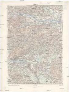
Maps of Varaždin County

Zagreb
1 : 200000 Záhřeb (Chorvatsko : oblast) Kartografska radionica
Jonction de la Drave a la Save
1 : 245000 Chorvatsko
Routen von und nach dem Badeorte Töplitz
Varaždinske Toplice (Chorvatsko) C. Albrecht
Agram.
from Spezialkarte der osterreichisch-ungarischen Monarchie.
Krapina und Zlatar.
from Spezialkarte der osterreichisch-ungarischen Monarchie.
Dubrava und Gradec.
from Spezialkarte der osterreichisch-ungarischen Monarchie.
Yugoslavia 1:100,000, Ptuj
Yugoslavia 1:100,000 , Series GSGS 4396. Great Britain. War Office. [London] : War Office
Stÿriae Ducatus Fertilisimi Nova Geographica Descriptio
1 : 200000 Mollova mapová sbírka Vischer, Georg Matthaeus Trost, Andreas
Koprivnica
1 : 75000 Koprivnica
Zagreb
1 : 75000 Zagreb
Krapina
1 : 75000 Krapina
Dubrava
1 : 75000 Zagreb
Kopreinitz und Kreuz.; Spezialkarte der osterreichisch-ungarischen Monarchie.
from Spezialkarte der osterreichisch-ungarischen Monarchie. Austro-Hungarian Monarchy. Militärgeographisches Institut.,
Pettau und Vinica.
from Spezialkarte der osterreichisch-ungarischen Monarchie.
Zone 20, Col. XIV, Pettau und Vinica, uit: Geologische Karte der im Reichsrathe vertretenen Königreiche und Länder der Österreich-Ungarischen Monarchie : auf Grundlage der Specialkarte i.M. 1:75.000 des k.u.k. Militär-geographischen Institutes / neu bearb. und als Kartenwerk von 341 Blattnummern in zwanglosen Lfg. hrsg. durch die k.k. Geologische Reichsanstalt in Wien
1 : 75000 titelvariant: Geologische Spezialkarte der im Reichsrate vertretenen Königreiche und Länder der Österreichisch-Ungarischen Monarchie; Geologische Specialkarte der im Reichsrathe vertretenen Königreiche und Länder der Österreichisch-Ungarischen Monarchie; Annotatie: Titel bovenaan kaartblad: Geologische Spezialkarte der im Reichsrate vertretenen Königreiche und Länder der Österreichisch-Ungarischen Monarchie en Geologische Specialkarte der im Reichsrathe vertretenen Königreiche und Länder der Österreichisch-Ungarischen Monarchie; Annotatie geografische gegevens: Coördinaten gebaseerd op nulmeridiaan van Ferro (Hierro) Kaiserlich-Königliche Geologische Reichsanstalt, Wenen Wien : K.K. Geologische Reichsanstalt
Warasdin
1 : 75000 Varaždin, Varaždin (Region)
Pettau
1 : 75000 Ptuj, Ptuj (Region)
Warasdin und Kotor.; Spezialkarte der osterreichisch-ungarischen Monarchie.
from Spezialkarte der osterreichisch-ungarischen Monarchie. Austro-Hungarian Monarchy. Militärgeographisches Institut.,
Velika Corica
1 : 75000 Velika Gorica
Grad Zagreb i nacrt novo pripojenog teritorija
Záhřeb (Chorvatsko) Lav. Hartman
Tlovid Topličke okolice
1 : 13000 Varaždinske Toplice (Chorvatsko) Drag. Albrecht
Stÿriae Ducatus Fertilisimi Nova Geographica Descriptio
1 : 200000 Mollova mapová sbírka Vischer, Georg Matthaeus Trost, Andreas
Velika Corica und Lekenik.
from Spezialkarte der osterreichisch-ungarischen Monarchie.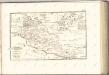

Ivanic Klostar und Moslavina.
from Spezialkarte der osterreichisch-ungarischen Monarchie.
Ivanić Kloštar
1 : 75000 Kloštar Ivanić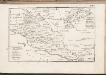
C. Szaladiensis. Tab. I
Ungarn Komitat Zala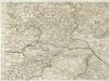
Augustissimo Romanor. Imperatori Iosepho I. Hungaria Regi Invictissimo Mappam Hanc Regni Hungariae
1 : 540000 Mollova mapová sbírka Müller, Johann Christoph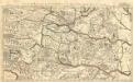
Partie du Royaume de Hongrie
1 : 680000 Mollova mapová sbírka Coronelli, Vincenzo Maria Nolin, Jean-Baptiste I.