Maps of Caucasus Mountains

Geographisch historische Karte des Kriegsschauplatzes in Asien in den Jahren 1828 u. 1829
Asie Ehrenkreutz, Br. von Biergans, R. von C. V. Sommerlatt
Kaukasien
1 : 2600000 Kavkaz (pohoří : oblast) Bibliographisches Institut
Feuille 34 (F V), uit: Carte géologique internationale de l'Europe : la carte, votée au congrès géologique international de Bologne en 1881, est exécutée conformément aux décisions d'une commission internationale, avec le concours des gouvernements, sous le dir. de M.M. Beyrich et Hauchecorne
Annotatie: Blad 48 gamme des couleurs; blad 49: bladwijzer en titelblad Heinrich Ernst Beyrich 1815-1896; Wi. Hauchecorne Berlin : Reimer / (Berlin: Institut lithographique)
Charta tēs Hellados en hē periechontai hai nēsoi autēs [kai] meros tōn eis tēn Eurōpēn [kai] Mikran Asian polyarithmōn apoikiōn autēs
1 : 600000 R?gas, Velestinl?s, 1757?-1798 Franz Müller
Die Völker des Kaukasus u.s.w. / gezeichnet u. gestochen in der geogr. Kunstschule zu Potsdam
1 : 2900000 1 Karte : Kupferdruck ; 31 x 39 cm Berghaus, Heinrich Karl Wilhelm J. Perthes
Caucasus.
1 : 3500000 Andree, Richard; Times (London, England)
The Caucasus
1 : 3500000 Andree, Richard
Karta Kavkazskago kraja
1 : 1080000 Baku (Ázerbájdžán) izdanie Kartografičeskago zavedenija A. Il'jina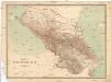
Karta Kavkazskago kraja
1 : 1080000 Kavkaz (pohoří : oblast) Kartografičeskago zavedenija A. Il'jina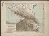
Karte für die Niederschlagsverhältnisse und die Verbreitung der wichtigsten Holzgewächse in den Kaukasusländern
1 : 4500000 Radde, Gustav Engelmann
Die Völker des Kaukasus, Grusien's und des Armenischen Hochlandes
Zweiter Band, enthaltend in vier Abtheilungen die Vertheilung der Organismen: 5. Pflanzen-Geographie, 6. Thier-Geographie, 7. Anthropographie, 8. Ethnographie Humboldt, Alexander von Verlag von Justus Perthes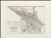
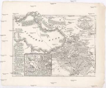
Kriegsschauplatz im Kaukasus
1 : 2600000 nach den besten Materialien bearb. und hrsg. von Albrecht Platt Magdeburg : Fr. Kaegelmann
Höhenschichtenkarte der Kaukasusländer mit Reiserouten Dr. G. Raddes
1 : 4500000 Radde, Gustav Engelmann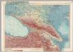
U.S.S.R. - Caucasia. Pergamon World Atlas.
1 : 2500000 Polish Army Topography Service
Karte des Kaukasischen Isthmus
Grosser Hand-Atlas über alle Theile der Erde in 170 Karten Meyer, J. Verlag des Bibliographischen Instituts
Kaukasus.
1 : 2600000 Grassl, J. (Joseph)
Die Volker des Kaukasus U.S.W.
1 : 3000000 Berghaus, Heinrich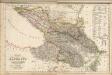
Composite: Kaukasus.
1 : 2050000 Handtke, Friedrich H.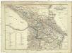
Karta Rossijskich vladěnij za Kavkazom
1 : 1680000 Kavkaz-oblast Kolokolov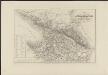
Carte des possessions russes au-delà du Caucase indiquant les frontières actuelles de la Russie, de la Turquie et de la Perse, dressée sur des documents officiels
1 : 750000 gravé sur pierre [par Alex. Zakrzewski] Imp. Lith. de Thierry Paris : A. Leneveu
Sbornyje list 5-ti verstnoj karty Kavkaza
1 : 1778000 Kavkaz (pohoří : oblast)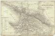
Carte des possessions russes au-dela du Caucase et des provinces turques limitrophes
1 : 1700000 Kavkaz-oblast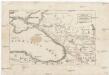
Uebersichts-Karte des russisch-türkischen Kriegsschauplatzes
Kavkaz-oblast Ludwig, J. von J. Ludwig und A. Zang
Charte der Laender am Caucasus
1 : 2200000 Kavkaz-oblast Reinecke, Johann Christoph Matthias
Charte der Laender am Caucasus
1 : 2200000 Kavkaz-oblast Reinecke, Johann Christoph Matthias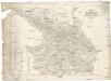
Karte des Kaukasus
Kavkaz-oblast Mahlmann, H. bei F.H. Morin
Karta Kavkaza dlja pojasnenija vojennych dějstvij ot načala 1838go goda po konec 1842 goda
Kavkaz-oblast
Charte der Laender am Caucasus
1 : 2100000 Kavkaz (pohoří : oblast) Reinecke, Johann Christoph Matthias
CHARTE der LAENDER AM CAUCASUS
1 : 2100000 Kavkaz-oblast Reinecke, Johann Christoph Matthias